
|  | 
| |||
 |
Grand Canyon National Park | 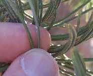
| |||

|  
|
Introduction and Explanation of Plant Trail Guides
Introduction
Highlights of This Trail
Fieldwork Dates and Summary of List Changes With Time
The Plant Guide
Key to Plant Guide Information
Introduction To The Linked Species Pages
Introduction
The guide has been updated from the fieldwork on 4/25/09 and 4/26/09, but the rest of this page hasn't been updated.
This is a preliminary plant trail guide to the South Kaibab Trail to mile 2.7, resulting from just two days of field work on 23-24 August 2008. It is therefore undoubtedly incomplete, especially for annuals and perennials, missing a number of such species that are seen only in wetter years or earlier in the year. However, it should be fairly complete for the larger shrubs and trees on the trail.
A plant trail guide gives the location of the first occurrence of every taxon (species and subspecies) found on the trail, as well as an estimate of the abundance of each taxon. It enables a botanist to know exactly where to find a given species, and gives the identification for species seen as one hikes along a trail. It is much more useful in the field than a traditional plant list by family, since the plants are seen in the trail in the order of the plant trail guide, and one doesn't have to figure out the determination from a large plant list by family.
In this plant trail guide, the common name of many species is linked to a separate webpage that shows photographs taken on 23-24 August 2008. For most taxa, these photographs serve as vouchers for my determinations, allowing botanists to confirm or question my determinations. ☺
The photographs also enable armchair botanists to take a virtual tour through all the species seen those days on the trail.
Since most species were not in bloom then, the photographs in general don't look anything like the pretty pictures of flowers shown in most field guides. However, this more nearly reflects what the plants look like most of the year, and hence may actually be more beneficial for most botanists trying to identify the species on the trail.
Since I am a botanist, the photographs were taken with identification of the species in mind. Almost every species has at least one picture with an object in it that can be used as a scale to make good measurements of the lengths of the parts needed for identification. Objects used for scale are: my fingers (widths ~ 18 mm = 0.7 inches) or my thumb (width ~23 mm = 0.9 inches; thumbnail width ~16 mm = 0.6 inches); my GPS receiver (11.0 cm long x 5.2 cm wide = 4.3 x 2.0 inches); or my backpack (15 inches tall x 16.5 inches wide x ~10 inches deep = 38 x 42 x 25 cm).
As far as possible, I used my knowledge of what characteristics are usually used to distinguish each species, and targeted those with my photographs. The discriminating characteristics vary tremendously between genera and families, and can range from the branching habit at the base of the plant, the characteristics of the underneath or shape or hairs of the leaf, to properties of the twigs. Sometimes, botanists even use the characteristics of the flowers, even though it often doesn't seem like it when photographers send pictures to botanists to be identified! ☺
Of course, some species do not have their identifying characteristics on display in September, so not all species will have those characteristics photographed.
Important Caveats:
- I make no guarantees at all that all the determinations (=identifications) here are correct. Although the vast majority of the determinations are probably correct, I would be surprised if there are not at least one or two misdeterminations here. It takes a number of days of fieldwork spread throughout the year, and review of the determinations by an expert, to catch some errors.
- You must pay attention to the id? column in the guide below. That column tells you how confident I am in each determination. If I indicate that a given determination has 95% confidence, as many as 5% of those determinations could be wrong.
- I am not an expert in the plants of Arizona. My expertise is in the plants of southern California; over half of the species here are not found in southern California.
Many of the determinations were based on a reasonable guess as to the correct species, or by my keying of the plants among species unfamiliar to me, or by my assuming that, if the Grand Canyon flora only lists one possible determination, then that determination is the correct one. I note that the latter approach would have resulted in an erroneous determination for Polygonum arenastrum if I had not been able to explicitly key out that species, and interested in doing so.
A key is a horrible way to identify species outside the hands of someone very familiar with a given flora. For example, only through the use of a key could an elephant be keyed as a "mouse", since keys often depend on subtle features in order to reliably discriminate species. But a key is the best means we have for discriminating species, and they work well if one is familiar with most of the species in the key. An expert in the plants of Arizona would be far less likely to make a bonehead mistake in keying out plants than an Arizona novice like me.
The reader may be amused to know that most botanists do not identify plants in the field when they are working on the flora of an area except possibly for the most common or unique species. Instead, they collect specimens, which are then pressed and dried. The specimens are then taken to a herbarium that has similar samples of all the possible identifications that have been determined by experts in those taxa. The specimens are directly compared, with the aid of a key and a microscope, to the labeled herbarium specimens to get the determination. (By the way, botanical keys are almost always made from, and for, pressed and dried specimens, which is definitely a problem at times in keying live plants.)
I collected no specimens; all my determinations have been made from my photographs and field observations. (Note that taking anything from Grand Canyon National Park is prohibited unless you have a permit to do so in your possession.) Hence the likelihood of a misdetermination is much higher than determinations made from specimens.
I would greatly appreciate it if anyone who spots a mistake, or even questions a determination, would contact me so mistakes can be corrected. Additions to the guide are welcome as well, especially if documented by photographs and good locations.
My determinations would not have been possible without the excellent resources available that I consulted. Many people have worked on the Grand Canyon Flora, collecting specimens, curating the specimens in herbaria, reviewing the determinations of those specimens, making the information from specimens available online, taking photographs and identifying the plants in those photographs, writing books, and synthesizing the available information in keys and floras. I am deeply grateful to all those people. I especially thank Lori Makarick, who provided the latest Grand Canyon Park Plant Checklist. That list was helpful in quickly getting the proper determination for several species.
A reference page gives the taxa found on this trail in traditional family order. For each taxon, that page links to online references and gives detailed references to printed reference material.
A list of just the species with species pages is given here: Bright Angel Trail and South Kaibab Trail: Checklist of Species With Pictures.
Highlights of This Trail
Fieldwork Dates and Summary of List Changes With Time
The following table gives the dates the trail was walked and taxa recorded. After each visit, the table gives the total number of taxa on the list and the breakdown of the taxa without positive identification. See Explanation of Plant Trail Guides to understand the symbols below.
| Visit Date | Visit # | # taxa | # "?" | # "sp" | # "~" | # "ssp" |
|---|
The Plant Guide
Key to Plant Guide Information
Mile: It is like a car odometer. Mile 0.00 includes all mileages from 0.000 to 0.009; 0.01 includes all mileages from 0.010 to 0.019, etc. 0.01 mile is 18 yards = 53 feet, about 18-20 normal-size paces.
Note that species separated by a difference of 0.01 mile in the guide could actually be fairly close together, with the odometer "rolling over" between them. Example: one species is at 1.599 miles, reported as 1.59 miles in the guide, and the next species is at 1.601 miles, reported as 1.60 miles in the guide. The species are actually just 0.002 miles = 10 feet apart. They could also be almost 0.02 miles apart. Example: one species is at 1.601 miles and the next is at 1.619 miles.
The mileage for this guide is nowhere near as accurate as the mileage for the Bright Angel Trail. I primarily relied on GPS points recorded in the field for every location, and for the elevations. Note that GPS readings often have considerable error in canyons, due to poor satellite visibility and errors due to satellite signals taking multiple paths to the receiver due to reflections from the many exposed rock faces here.
In fact, GPS receivers are almost useless in some parts of the trail due to these problems. Be very wary about believing the trip mileage given by a GPS receiver.
Since most people walk without a pedometer or a GPS to give them their rough mileage, enough landmarks are included in the guide that it is not necessary to pay much attention to the mileage. It is mainly useful in telling the reader when there are long intervals without new species, or when new species come fast and furious.
S: Side of trail on which the first occurrence is found: left, right, both, or center
#: On-trail species are numbered in order of first occurrence on trail (easily touchable from the trail). Off-trail species are in parentheses.
id?: Species without an entry in this column are quite confidently identified. "?" means I am just guessing the identification; "sp" means the genera is probably known, but the species name is uncertain even when a potential species name is given in the guide; "~" means I have roughly 95% confidence that this is the determination, but have not yet positively identified it; "ssp" means the subspecies or variety needs to be determined.
FAM: The family for each taxon is given as the first three letters of the full scientific family name, with all letters capitalized. See the key to the three letter abbreviations.
(*)Common Name: An asterisk before the common name indicates a species that is non-native to the Grand Canyon, and hence should not be here. The Common Name is linked to a separate page for each species giving photographs and further information about some species. The Common Name in many cases has been taken from my southern California database for expediency. If you know of a better common name used at the Grand Canyon, please let me know.
Note that common names are not standardized, and more than one taxa can have the same common name.
Scientific Name: This is the name used to uniquely identify a species by botanists, which enables one to confidently look up more information about each species. All names are as given in the latest Grand Canyon flora online. Synonyms (older, newer, or alternate Scientific Names) are given in the page linked to the common name, usually via the USDA Plants link.
#Plants: This gives the minimum number of on-trail plants of this species on this trail, with the number of locations on this trail following the /, using maximum values of 99/9. A value of 1/1 means I only found a single plant in a single location in the entire trail; 10/9 means 10 plants occurring in at least 9 locations, etc. Very common taxa are generally given as 50/9 or 99/9, with the 99/9 species being significantly more abundant than the 50/9 species.
Introduction To The Linked Species Pages
Many species in the plant trail guide have additional information given on a separate page that is linked from the Common Name field below. The additional information includes:
Characteristics: This section begins with Identification status, which gives a discussion of how confident I am in the determination. The identification and other characteristics of each species are discussed. The explicit keying is given in some cases.
Some species have additional discussion about the species in the Grand Canyon and/or elsewhere.
Voucher information is given, including the number of vouchers in the entire Grand Canyon and the closest voucher to the Bright Angel Trail. Voucher information was obtained from the Southwest Biodiversity Consortium (formerly SEINet).
The information given in the guide below about the location and number of plants is repeated on each species page.
Unfortunately, due to the amount of time it took me to make a full species page, some species have just the pictures and reference information on the species pages, without the additional information mentioned above.
Pictures: Pictures of each species taken on the Bright Angel Trail are presented, often with the identification characteristics explicitly pointed out.
References: References are given to 13 sources, including links to online references and page numbers for printed references.
Version for printing, without lines and other text on this page: html (6 pages) or pdf Clickbook booklet (2 double-sided pages). (See printing instructions for an explanation of these options)
| Mile | S | # | id? | FAM | (*)Common Name | Scientific Name | #Plants |
|---|---|---|---|---|---|---|---|
| Mile | side | # | id? | landmarkFAM | Nativitylink to pixCommon Name | Scientific Name# plants on trail# locations | |
| 0.00 | South Kaibab Trailhead; elevation 7200 feet (2195 m). Begin guide at display boards: left: "A Hike to Cedar Ridge"; right: "South Kaibab Trail". VIS, juniper mistletoe, Phoradendron juniperinum, just before trailhead; look for it on trail. In 2012, the beginning of the trail has been changed, so the first species are probably no longer present at their first location. | ||||||
| 0.00 | b | 1 | PIN | two-needle pinyon pine | Pinus edulis | 50 / 9 | |
| 0.00 | b | 2 | VIS | pinyon pine dwarf-mistletoe | Arceuthobium divaricatum | 25 / 9 | |
| 0.00 | b | 3 | ROS | Utah service-berry | Amelanchier utahensis | 50 / 9 | |
| 0.00 | l | 4 | CHE | Fremont's goosefoot | Chenopodium fremontii | 50 / 9 | |
| 0.00 | r | 5 | CHE | *Russian thistle | Salsola tragus | 5 / 2 | |
| 0.00 | r | (BRA Wright's thelypody, Thelypodium wrightii) | |||||
| 0.00 | b | 6 | AST | silver wormwood | Artemisia ludoviciana | 99 / 9 | |
| 0.00 | r | 7 | POA | *downy brome | Bromus tectorum | 99 / 9 | |
| 0.00 | r | 8 | BRA | *crossflower | Chorispora tenella | 99 / 9 | |
| 0.00 | r | 9 | AST | hoary-aster | Dieteria canescens | 50 / 9 | |
| 0.00 | r | 10 | POA | *foxtail barley | Hordeum murinum | 99 / 9 | |
| 0.00 | r | 11 | BRA | *herb sophia | Descurainia sophia | 99 / 9 | |
| 0.00 | r | 12 | POA | Indian ricegrass | Achnatherum hymenoides | 40 / 9 | |
| 0.00 | l | 13 | BRA | perennial rock-cress | Boechera perennans | 50 / 9 | |
| 0.00 | l | 14 | POA | mutton grass | Poa fendleriana | 99 / 9 | |
| 0.00 | l | (HYD Utah fendlerbush, Fendlerella utahensis) | |||||
| 0.00 | l | (CUP, Utah juniper, Juniperus osteosperma; VIS, juniper mistletoe, Phoradendron juniperinum; AST, Basin butterweed, Packera multilobata; CAP, snowberry, Symphoricarpos oreophilus; AST Rock Goldenrod, Petradoria pumila; fern bush, Chamaebatiaria millefolium) | |||||
| 0.00 | l | 15 | RAN | *curveseed butterwort | Ceratocephala testiculata | 99 / 9 | |
| 0.00 | l | 16 | AST | big sagebrush | Artemisia tridentata | 99 / 9 | |
| 0.00 | l | 17 | SCR | toadflax penstemon | Penstemon linarioides | 20 / 9 | |
| 0.00 | l | (whisky currant, Ribes cereum var. cereum) | |||||
| 0.00 | Switchback right | ||||||
| 0.01 | l | 18 | CHE | *tumbling oracle | Atriplex rosea | 2 / 2 | |
| 0.01 | r | 19 | GRO | whisky currant | Ribes cereum var. cereum | 20 / 7 | |
| 0.01 | r | 20 | POA | squirreltail | Elymus elymoides | 20 / 9 | |
| 0.02 | b | 21 | AST | Grand Canyon Goldenweed | Ericameria arizonica | 30 / 7 | |
| 0.02 | r | 22 | CAP | snowberry | Symphoricarpos oreophilus | 30 / 9 | |
| 0.02 | r | 23 | EPH | green ephedra | Ephedra viridis | 50 / 9 | |
| 0.02 | r | 24 | AST | Grand Canyon rock-daisy | Perityle congesta | 50 / 9 | |
| 0.02 | l | 25 | ~ | CAC | Mojave prickly-pear (not seen in 2009) | Opuntia polyacantha var. erinacea | 3 / 3 |
| 0.02 | l | 26 | AST | Basin butterweed | Packera multilobata | 20 / 9 | |
| 0.02 | l | (beardtongue, Penstemon barbatus) | |||||
| 0.02 | l | 27 | CUP | Utah juniper | Juniperus osteosperma | 20 / 9 | |
| 0.03 | r | 28 | RUB | Wright's bedstraw | Galium wrightii | 40 / 9 | |
| 0.03 | r | 29 | ROS | cliffrose | Purshia stansburyana | 40 / 9 | |
| 0.03 | l | 30 | SCR | beardtongue | Penstemon barbatus | 10 / 4 | |
| 0.03 | l | 31 | BRA | Wright's thelypody | Thelypodium wrightii | 30 / 9 | |
| 0.03 | r | 32 | POL | southern mountain phlox | Phlox austromontana | 30 / 9 | |
| 0.04 | r | 33 | AST | Cooper�s rubberweed | Hymenoxys cooperi | 10 / 9 | |
| 0.04 | l | 34 | AST | California brickellbush | Brickellia californica | 30 / 7 | |
| 0.04 | l | 35 | SCR | Palmer's penstemon | Penstemon palmeri | 30 / 9 | |
| 0.04 | l | 36 | LAM | *horehound | Marrubium vulgare | 3 / 3 | |
| 0.04 | l | 37 | ~ | AST | sticky snakeweed | Gutierrezia microcephala | 99 / 9 |
| 0.04 | Switchback left and curve right at sign "When mules pass" | ||||||
| 0.04 | l | 38 | POA | *smooth brome | Bromus inermis | 99 / 9 | |
| 0.04 | l | 39 | POL | Simpson's buckwheat | Eriogonum microtheca var. simpsonii | 50 / 9 | |
| 0.04 | r | (PIN, Rocky Mountain Douglas-fir, Pseudotsuga menziesii var. glauca) | |||||
| 0.05 | l | 40 | SCR | beaked penstemon | Penstemon rostriflorus | 10 / 7 | |
| 0.05 | l | 41 | CAR | Eastwood's sandwort | Arenaria eastwoodiae | 5 / 2 | |
| 0.06 | r | 42 | ROS | fern bush | Chamaebatiaria millefolium | 1 / 1 | |
| 0.06 | Switchback left at ridge | ||||||
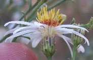
| 0.06 | l | 43 | AST | beautiful aster | Eurybia glauca var. pulchra | 40 / 9 | |
| 0.06 | l | 44 | FAB | freckled milk-vetch | Astragalus lentiginosus | 50 / 9 | |
| 0.06 | r | (Gambel oak, Quercus gambelii) | |||||
| 0.06 | l | 45 | POL | scarlet gilia | Ipomopsis aggregata ssp. formosissima | / | |
| 0.06 | l | (Fendler's meadow-rue, Thalictrum fendleri) | |||||
| 0.07 | l | 46 | POA | slender wheatgrass | Elymus trachycaulus | 20 / 3 | |
| 0.07 | l | 47 | PIN | Rocky Mountain Douglas-fir | Pseudotsuga menziesii var. glauca | 5 / 5 | |
| 0.07 | b | 48 | BRA | mountain pepper-grass | Lepidium montanum | 30 / 7 | |
| 0.09 | Switchback right at sign "No dogs" | ||||||
| 0.11 | Switchback left | ||||||
| 0.12 | r | In distance, leaning block of Coconino Sandstone | |||||
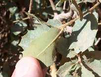
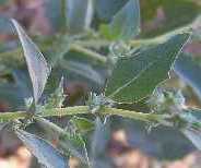
| 0.12 | r | 49 | FAG | Gambel oak | Quercus gambelii | 5 / 2 | |
| 0.13 | Switchback right at sign "No shortcutting or rolling rocks; hikers below" | ||||||
| 0.15 | Switchback left | ||||||
| 0.15 | Switchback right and curve left | ||||||
| 0.16 | r | 50 | GRO | trumpet gooseberry | Ribes leptanthum | 2 / 2 | |
| 0.16 | Switchback left | ||||||
| 0.16 | r | First live Basin butterweed, Packera multilobata, in 2009. | |||||
| 0.16 | r | (baby pallid hoptree, Ptelea trifoliata) | |||||
| 0.17 | l | (Arizona thistle, Cirsium arizonicum) | |||||
| 0.17 | r | 51 | HYD | little-leaf mock orange | Philadelphus microphyllus | 1 / 1 | |
| 0.17 | Switchback right | ||||||
| 0.20 | r | 52 | RAN | Fendler's meadow-rue | Thalictrum fendleri | 1 / 1 | |
| 0.20 | r | 53 | ~ | SCR | thickleaf beardtongue | Penstemon pachyphyllus var. congestus | 10 / 9 |
| 0.20 | r | 54 | sp | NYC | smooth spreading four o'clock or trailing four-o'clock | Mirabilis oxybaphoides or Mirabilis pumila | 1 / 1 |
| 0.20 | r | (dentnut cryptantha, Cryptantha abata) | |||||
| 0.20 | r | 55 | AST | Arizona thistle | Cirsium arizonicum | 70 / 5 | |
| 0.20 | r | 56 | HYD | Fendler bush | Fendlera rupicola | 10 / 5 | |
| 0.22 | r | 57 | AST | Arizona hymenoxys | Tetraneuris acaulis var. arizonica | / | |
| 0.23 | l | Sign: "Warning!"; elevation ~7000 feet (2130 m) | |||||
| 0.23 | l | 58 | AST | matchweed | Gutierrezia sarothrae | 5 / 3 | |
| 0.26 | r | (banana yucca, Yucca baccata) | |||||
| 0.26 | l | (Kaibab century plant, Agave utahensis var. kaibabensis) | |||||
| 0.26 | l | 59 | ? | POA | one-sided grass | 1 / 1 | |
| 0.26 | r | (Torrey's milkvetch, Astragalus calycosus) | |||||
| 0.26 | b | 60 | BOR | dentnut cryptantha | Cryptantha abata | 15 / 4 | |
| 0.26 | l | 61 | AGA | banana yucca | Yucca baccata | 2 / 2 | |
| 0.26 | l | 62 | sp | AST | leafy aster | Erigeron sp. | 5 / 2 |
| 0.27 | l | 63 | FAB | Torrey's milkvetch | Astragalus calycosus | 50 / 9 | |
| 0.27 | b | (Field of AST, Rock Goldenrod, Petradoria pumila) | |||||
| 0.28 | r | (hairy goldenaster, Heterotheca villosa) | |||||
| 0.37 | r | 64 | AST | hairy goldenaster | Heterotheca villosa | 40 / 9 | |
| 0.38 | l | 65 | AGA | Kaibab century plant | Agave utahensis var. kaibabensis | 10 / 9 | |
| (first off-trail CAC, Mojave prickly-pear, Opuntia polyacantha var. erinacea, in 2009) | |||||||
| 0.39 | r | 66 | ~ | BOR | slender cryptantha | Cryptantha gracilis | 40 / 5 |
| 0.39 | l | (greenstem paperflower, Psilostrophe sparsiflora) | |||||
| 0.40 | r | tidy fleabane | Erigeron concinnus | 7 / 3 | |||
| 0.40 | r | 67 | AST | Rock Goldenrod | Petradoria pumila | 20 / 9 | |
| 0.40 | l | 68 | AST | threadleaf common rabbitbrush | Ericameria nauseosa var. oreophila | 50 / 9 | |
| Need to get mileages for the following, and place the trail curves right correctly: | |||||||
| r | (LIN, Lewis' flax, Linum lewisii) | ||||||
| b | 69 | POA | *red brome | Bromus rubens | / | ||
| r | (Parish needlegrass, Achnatherum parishii) | ||||||
| r | (spiny greasebush, Glossopetalon spinescens var. aridum) | ||||||
| 0.45 | Trail curves right at small ridge; elevation ~6800 feet (2070 m) | ||||||
| r | (prickly pear with fat pads, Opuntia sp.) | ||||||
| b | 70 | SCR | purple bird's-beak | Cordylanthus parviflorus | 20 / 5 | ||
| l | 71 | sp | CAC | prickly pear with narrow pads | Opuntia sp. | 1 / 1 | |
| 0.50 | r | 72 | AST | greenstem paperflower | Psilostrophe sparsiflora | 50 / 9 | |
| 0.56 | (SCR, desert paintbrush, Castilleja chromosa) | ||||||
| 0.56 | r | 73 | LIN | Lewis' flax | Linum lewisii var. lewisii | / | |
| 0.57 | l | 74 | ROS | Apache plume | Fallugia paradoxa | 10 / 3 | |
| 0.58 | r | 75 | GER | *redstem filaree | Erodium cicutarium | 99 / 9 | |
| 0.65 | l | 76 | AST | black sagebrush | Artemisia nova | / | |
| 0.65 | l | 77 | CAC | prickly pear with big pads | Opuntia sp. | 7 / 2 | |
| Check order of species from mile 0.68 to mile 0.81 | |||||||
| 0.68 | r | 78 | AST | longleaf brickellbush | Brickellia longifolia | 40 / 9 | |
| 0.68 | r | 79 | AST | fragrant snakeroot | Ageratina herbacea | 5 / 1 | |
| 0.70 | r | 80 | RHA | birchleaf buckthorn | Frangula betulifolia ssp. obovata | 1 / 1 | |
| 81 | claret cup | Echinocereus triglochidiatus var. mojavensis | / | ||||
| 0.73 | r | 82 | CRO | spiny greasebush | Glossopetalon spinescens var. aridum | 50 / 9 | |
| 0.73 | r | 83 | BRA | *shepherd's purse | Capsella bursa-pastoris | / | |
| 0.73 | l | (ROS, true mountain-mahogany, Cercocarpus montanus) | |||||
| 0.75 | r | Sign: Ooh-Aah Point | |||||
| 0.75 | Switchback left at Ooh-Aah Point | ||||||
| 0.78 | b | 84 | sp | CAC | prickly pear with fat pads | Opuntia sp. | 2 / 1 |
| 0.81 | Switchback right; elevation ~6600 feet (2010 m) | ||||||
| 0.81 | l | (AST, Missouri goldenrod, Solidago missouriensis) | |||||
| 0.83 | l | (GAR, ashy silk tassel, Garrya flavescens) | |||||
| 0.85 | r | 85 | LAM | Drummond's false pennyroyal | Hedeoma drummondii | 1 / 1 | |
| 0.87 | r | 86 | MAL | *common mallow | Malva neglecta | 1 / 1 | |
| 0.90 | l | (CAC Engelmann's hedgehog cactus, Echinocereus engelmannii ssp. engelmannii) | |||||
| 0.91 | Trail turns right 90° | ||||||
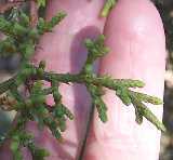
| 0.91 | r | 87 | SEL | spike-moss | Selaginella mutica | 10 / 1 | |
| 0.91 | r | 88 | ROS | true mountain-mahogany | Cercocarpus montanus | 50 / 9 | |
| 0.93 | Switchback left | ||||||
| 0.96 | Switchback left | ||||||
| 0.97 | Switchback right; elevation ~6400 feet (1950 m) | ||||||
| 1.02 | Switchback right | ||||||
| 1.06 | l | 89 | RUT | pallid hoptree | Ptelea trifoliata ssp. pallida var. pallida | 5 / 5 | |
| 1.07 | Switchback left; lowest Grand Canyon Goldenweed, Ericameria arizonica | ||||||
| 1.10 | l | 90 | RUB | Munz's bedstraw | Galium munzii ssp. ambivalens | 30 / 9 | |
| 1.14 | b | 91 | API | rockloving wavewing | Pteryxia petraea | 5 / 1 | |
| 1.14 | r | sp | (a different Arabis like A. pulchra?) | ||||
| 1.16 | Long switchback left | ||||||
| 1.19 | Switchback right; elevation ~6200 feet (1890 m) | ||||||
| 92 | HYD | Utah fendlerbush | Fendlerella utahensis | 30 / 5 | |||
| 1.24 | r | 93 | ~ | EUP | small-seeded spurge | Chamaesyce polycarpa | 10 / 2 |
| 1.25 | r | sp | (unk grass similar to Bouteloua) | ||||
| 1.28 | r | 94 | POA | Parish needlegrass | Achnatherum parishii | 40 / 9 | |
| 1.28 | l | 95 | LAM | blue sage | Salvia dorrii | 10 / 5 | |
| 1.28 | Sign: "Cedar Ridge"; elevation 6067 feet (1849 m) | ||||||
| 1.30 | Trail turns right 90° off ridge | ||||||
| 1.31 | Switchback left | ||||||
| 1.34 | r | 96 | BET | Knowlton hop hornbeam | Ostrya knowltonii | 1 / 1 | |
| 1.36 | l | 97 | BRA | heartleaf jewelflower | Streptanthus cordatus | 30 / 9 | |
| 1.36 | b | 98 | BRA | prince's plume | Stanleya pinnata | 40 / 9 | |
| 1.36 | b | Check for different Artemisia like tridentata | |||||
| 1.37 | l | (BER Fremont barberry, Mahonia fremontii) | |||||
| 1.41 | l | 99 | ? | AST | ? | unk Asteraceae shrub like Brickellia | / |
| 1.42 | Switchback right | ||||||
| 1.43 | Switchback left; elevation ~5900 feet (1800 m) | ||||||
| 1.45 | l | 100 | OLE | single-leaf ash | Fraxinus anomala | 3 / 3 | |
| 1.49 | l | 101 | NYC | giant four o'clock | Mirabilis multiflora | 20 / 7 | |
| 1.50 | l | 102 | ~ | POL | eyed gilia | Gilia ophthalmoides | 5 / 1 |
| 1.5 | l | 103 | CHE | fourwing saltbush | Atriplex canescens | 30 / 7 | |
| 1.56 | r | 104 | sp | POA | ? | unk grass similar to Bouteloua eriopoda | / |
| 1.57 | Brief flat part of trail with great views; elevation ~5800 feet (1770 m) | ||||||
| 1.61 | r | 105 | AST | rush rabbitbrush | Ericameria nauseosa var. juncea | 4 / 4 | |
| 1.62 | l | (BOR, capitate cryptantha, Oreocarya capitata) | |||||
| 1.63 | Saddle; trail leaves ridge to right | ||||||
| 1.63 | r | 106 | ANA | skunkbush | Rhus trilobata | / | |
| 1.63 | r | ? | (BRA, *African mustard, Malcolmia africana; unk per with opp bracts) | ||||
| 1.64 | r | 107 | ? | ? | unk per with opp bracts | / | |
| 1.69 | r | 108 | BRA | *African mustard | Malcolmia africana | 20 / 7 | |
| 1.7 | Switchback right | ||||||
| 1.73 | Switchback left; elevation ~5670 feet (1730 m) | ||||||
| 1.73 | r | (wire-lettuce, Stephanomeria pauciflora) | |||||
| 1.75 | r | (AST, Bigelow sagebrush, Artemisia bigelovii) | |||||
| 1.82 | l | 109 | POA | side-oats grama | Bouteloua curtipendula | 3 / 1 | |
| 1.84 | b | 110 | LOA | Adonis blazing star | Mentzelia multiflora | 40 / 9 | |
| 1.84 | l | 111 | HYD | narrow phacelia | Phacelia filiformis | 5 / 1 | |
| 1.84 | l | ? | (AST, fiveneedle pricklyleaf, Thymophylla pentachaeta; AST, tall plant with clasping leaves and purple-tipped phyllaries; dwarf false pennyroyal, Hedeoma nana ssp. nana) | ||||
| 1.85 | r | 112 | AST | wire-lettuce | Stephanomeria pauciflora | 2 / 1 | |
| 1.85 | r | 113 | POA | black grama | Bouteloua eriopoda | 5 / 2 | |
| 1.88 | l | (banana yucca, Yucca baccata, with a trunk) | |||||
| 1.92 | l | A glaucous mutton grass, Poa fendleriana | |||||
| 1.93 | Elevation ~5500 feet (1675 m) | ||||||
| 1.95 | l | 114 | SCR | desert paintbrush | Castilleja chromosa | 20 / 5 | |
| 1.96 | Trail curves left at ridge | ||||||
| 1.97 | l | 115 | NYC | dwarf sand verbena | Abronia nana | 5 / 3 | |
| 2.03 | l | 116 | ROS | little-leaved mountain-mahogany | Cercocarpus intricatus | 3 / 2 | |
| 2.03 | l | 117 | AST | Bigelow sagebrush | Artemisia bigelovii | / | |
| 2.05 | l | 118 | ? | AST | ? | unk per like Gnaphalium canescens ssp. beneolens | 1 / 1 |
| 2.15 | r | 119 | sp | BRA | beautiful rock-cress? | Arabis pulchra? | 3 / 1 |
| 2.16 | l | 120 | BRA | rose bladderpod | Lesquerella purpurea | 5 / 2 | |
| 2.23 | r | 121 | MAL | gooseberryleaf globemallow | Sphaeralcea grossulariifolia | 30 / 9 | |
| 2.23 | Elevation ~5300 feet (1615 m) | ||||||
| 2.28 | l | Trail is on top of breccia pipe, formed by roof collapse of a limestone cave, best exposed on saddle to left | |||||
| 2.29 | r | 122 | ? | AST | ? | shrub similar to Viguieria or Encelia | 1 / 1 |
| 2.29 | r | 123 | BRA | common pepper-grass | Lepidium densiflorum | 10 / 1 | |
| 2.29 | r | ? | (a perennial Eriogonum not E. inflatum?) | ||||
| 2.30 | r | 124 | POL | desert trumpet | Eriogonum inflatum | 20 / 5 | |
| 2.31 | r | 125 | ROS | black brush | Coleogyne ramosissima | 50 / 9 | |
| 2.36 | l | 126 | POA | hairy erioneuron | Erioneuron pilosum | 2 / 1 | |
| 2.43 | l | 127 | AST | rose heath | Chaetopappa ericoides | / | |
| 2.48 | l | ~ | (winding mariposa, Calochortus flexuosus; ~larkspur, ~Delphinium sp.) | ||||
| 2.50 | r | 128 | POA | fluff grass | Dasyochloa pulchella | 1 / 1 | |
| 2.50 | r | 129 | BRA | hairy-podded pepper-grass | Lepidium lasiocarpum var. lasiocarpum | 5 / 1 | |
| 2.50 | l | (CAC California barrel cactus, Ferocactus cylindraceus) | |||||
| 2.51 | r | (AST mariola, Parthenium incanum) | |||||
| 2.51 | r | 130 | AGA | soaptree yucca | Yucca elata | 1 / 1 | |
| 2.56 | r | 131 | LIL | winding mariposa | Calochortus flexuosus | / | |
| 2.56 | r | 132 | POA | James' galleta | Pleuraphis jamesii | 20 / 5 | |
| 2.72 | Skeleton Point; elevation ~5100 feet (1555 m); Begin series of switchbacks down the Redwall.End Plant Trail Guide | ||||||
| (many-headed barrel cactus, Homalocephala polycephala ssp. xeranthemoides off-trail at top of drop-off to west) | |||||||
| 4.40 | Jct. with Tonto Trail. Elevation 4000 feet | ||||||
| 4.60 | The Tip-Off | ||||||