Tiquilia canescens
Woody Crinklemat, Shrubby Coldenia
Woody Crinklemat, Shrubby Coldenia
Table of Contents
Introduction
Taxonomy
Habitat
Geographic Distribution

| 
|

| |

| |
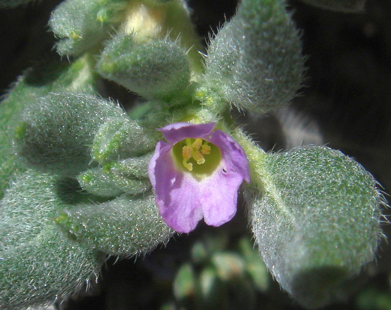
| Fig. 1. Tiquilia canescens, Woody Crinklemat, Shrubby Coldenia.
Top two rows: A rarely-seen happy blooming plant near the beginning of The Narrows Earth Trail, in Powder Dump Wash close to SR78, on 19 April 2010.
All pictures by Tom Chester. Click on the pictures for larger versions.
| |
Introduction
Tiquilia canescens is a low matted subshrub; see Fig. 1. It is uncommon in the Borrego Desert. Furthermore, those plants are rarely seen since they occur in places where most botanists don't go. There are no plants of this species found on any of the most popular trails and washes in our area.
Its sister species, T. palmeri and T. plicata, are frequently seen since they grow in or along washes. T. plicata is often found along roadsides as well. In contrast, in our area, T. canescens grows mostly on steep rock exposures, on rocky ridges, and rocky drainages — habitats that most hikers try to avoid.
In the core of its geographic distribution here, the Yaqui Ridge / The Narrows / Mescal Bajada Area, T. canescens is often found on what we call the "Strange White Rock", but it is by no means restricted to that rock type. We don't know for sure what this rock type is, but it is found near faults, and may be created by the circulation of hot water underground. The hot water alters the chemistry of the original rocks to produce rocks quite different from the parent material.
One thing we quickly learned about this species is that we could not predict in detail where it might be found! On our 2 February 2014 survey in Powder Dump / Quartz Vein Wash for this species, when we saw plants we would note the characteristics of their habitat (such as "south-facing" or "bare rock"), to try to predict the habitat preference of this species. But, usually within minutes, a plant would appear that was growing in a different habitat (such as "west-facing" or "rocky flats") outside our predictions. We eventually gave up, even though we don't give up easily for such things.
This species has continued to astound us by the varied habitats in which new populations have been found, such as a population discovered by Carla Hoegen and Fred Melgert in December 2017 that was quite disjunct from the rest of the population known at that time, and another discovered by Don Rideout in January 2022.
Taxonomy
T. canescens belongs in the Boraginales order of plants, which consists of 11 families. In the Borrego Desert, we have members of six of those 11 families. Those six, with a representative genus in our area in parentheses, are Boraginaceae (Cryptantha), Hydrophyllaceae (Phacelia), Namaceae (Nama), Heliotropiaceae (Heliotropium), Lennoaceae (Pholisma), and Ehretiaceae (Tiquilia). In the 2012 Jepson Manual Second Edition, all of these families were lumped together under Boraginaceae, but a Jepson eFlora later update adopted the split into 11 families.
DNA analysis shows that the closest relative of Tiquilia in our area is Pholisma! Both of these species are only distantly related to Cryptantha and Phacelia. For the latest phylogeny, see this poster from the Boraginales Working Group.
Of the ~28 known species of Tiquilia world-wide, we have three species of Tiquilia in the Borrego Desert, T. canescens, T. plicata, and T. palmeri. There is a fourth species in California, the annual T. nuttallii, but it isn't found in the Borrego Desert area.
Except for its flower, T. canescens does not closely resemble its two sister species in the Borrego Desert, since it does not have leaves with clearly visible veins on the top of the leaf, and it has alternate stem branches, not opposite branches. See the Jepson eflora illustration of the leaves for these species and the stem branching.
T. canescens is in fact only distantly related to T. plicata and T. palmeri. It is in subgroup Eddya, and the other two species are in subgroup Tiquilia. These subgroups differ in morphology, chromosome number, and habitat (Moore, Tye and Jansen 2006).
The Jepson eflora lists two varieties for this species, distinguished just on the size of the flower. Flowers 5 to 8 mm across are var. pulchella, and flowers 2.5 to 4.5 mm across are var. canescens. You'll be very lucky if you ever see a flower on these plants, since they grow in very dry habitats!
The plants in the Borrego Desert have been determined as var. canescens.
Habitat
Fig. 2 shows some of the varied habitats of T. canescens in our area.

| 
|

| 
|
| Fig. 2. Four of the different habitats which support T. canescens. Top left: The "Strange White Rock" cliff exposures in Bighorn Canyon. Top right: Rocky drainage in flattish area between Box Canyon and Butler Canyon. Bottom left: Slopes of highly-weathered "Strange White Rock" north of Yaqui Ridge. Bottom right: Flattish old eroded surface on top of the slopes in the bottom left pix.
Picture credits. Top left by Tom Chester. Top right by Fred Melgert. Bottom left by Steve Rogers. Bottom right by Don Rideout. Click on the pix to see larger versions. | |
The "Strange White Rock" which supports large numbers of T. canescens is found in the Yaqui Ridge / The Narrows / Mescal Bajada Area. There are also exposures of what seems to be a similar rock type at Pinyon Mountain and along the Elsinore Fault in the Agua Caliente Hot Springs area, but so far no plants of T. canescens have been found there.
T. canescens is not, however, confined to the Strange White Rock; it also grows in other habitats here. Plants are found in The Narrows area growing in neighboring different rock types, and as far as we know, the large population in the flattish area between Box Canyon and Butler Canyon has no strange white rock near it.
In areas outside of the Borrego Desert, the habitat preference of T. canescens is even more varied. Some of the habitats in those areas are:
- Sandy areas. In Arizona's Cabeza Prieta National Wildlife Refuge they say the plant prefers sand dunes and sandy areas, which is just about the exact opposite of the habitat here! It is also said to be common and widespread there, again the exact opposite of its abundance here.
Interestingly, its sister species here, T. plicata and T. palmeri do grow in such sandy areas here.
- Limestone areas. Felger et al 2015 say the plant prefers calcareous geology. Seinet also describes the plant as preferring limestone soils. Our "Strange White Rock" probably has a composition closer to limestone than our other soils here.
- Sandy or gravelly soils on desert plains, mesas, and along arroyos. Shreve and Wiggins, p. 1206.
- Rocky slopes and benches. Jaeger, p. 207.
- Clay soil. Texas Parks and Wildlife mentions that the plant is found in clay soil within quaternary alluvial, playa and caliche deposits.
Geographic Distribution
Fig. 3 shows the complete geographic distribution from vouchers for Tiquilia canescens for its entire range, from SEINet, and a zoomed version for its range in southern California and nearby areas.

|

|
| Fig. 3. Left: Geographic map from vouchers of the entire range for Tiquilia canescens. Right: Zoomed version of the same map showing a close-up of southern California and nearby areas.
Red markers show vouchers determined just to the species. Blue markers show vouchers of var. canescens. Yellow markers show voucher locations of var. pulchella. Click on either pix to go to the current SEINet full geographic map. | |
Fig. 3 shows that var. pulchella is confined to the southeast corner of California and the immediately-neighboring portion of Arizona.
Fig. 4 shows the geographic distribution of Tiquilia canescens in the Borrego Desert area, from iNat and from the surveys of Tom Chester and colleagues. Fig. 5 shows expanded views of those locations.

| 
|
| Fig. 4. Geographic distribution of all Tiquilia canescens GPS points in the Borrego Desert. Left: map with individual points. Right: map using the clustering algorithm of the Berkeley Mapper to show how many points are in each area. Since the GPS points are not derived from a uniform methodology, and surveys for this species are very incomplete, the number of points in each area should be interpreted with caution. For example, Don Rideout added 39 points, in a single very recent day, 29 January 2022, of the 61 points shown in one circle in the map! | |

|

|
| Fig. 5. Closer views of the geographic distribution of all Tiquilia canescens GPS points in the Borrego Desert.
Left: Closer view of the northernmost points. Right: Closer view of the rest of the points. Click on the pix to see larger versions. | |
Voucher locations were not used because their locations are not precise. There are only six collection events for vouchers of this species from San Diego County, from 1905, 1939, 1993, 1994, 1995, and 2016, and only three of those vouchers have coordinates accurate to ~1/4 mile. We have surveyed two of the georeferenced locations of those vouchers without finding any plants. But we did find plants at locations consistent with the 1/4 mile accuracy of the voucher locality.
The GPS points shown in Fig. 4 mostly come from Don Rideout at iNat (46); Fred Melgert and Carla Hoegen at iNat (45); and from the surveys Tom has done with colleagues (45; see below for names). From iNat, Joe Woods contributed 18 points, and four other people contributed one point each.
The surveys I've done in the past that have found Tiquilia canescens, in time order, are:
- 3 December 2010, Yaqui Pass up Pinyon Ridge to "Salazaria Plateau", with James Dillane and Charlie Jones.
- 2 February 2014, Mine Canyon and Mine Wash, and Power Dump / Quartz Vein Wash, with Kate Harper and Keir Morse.
- 5 December 2014, Ridge east of Yaqui Pass, with Adrienne Ballwey, Jim Roberts, and Jeff Field.
- 23 December 2014, Yaqui Pass and Ridge to east, with Keir Morse, James Dillane, and Pam Pallette.
- 30 November 2014, Lizard Canyon East Fork, with Keir Morse, Adrienne Ballwey, Angelique Herman, and Whitney Meier.
- 6 January 2018, Unnamed wash east of sunset wash.
- 15 February 2018, Vallecito Hills, with Nancy Accola.
The maps linked below show many of the surveys that Tom and colleagues have done in areas where Tiquilia canescens has been found. Some of those surveys were specifically targeted for Tiquilia canescens, and hence show where we have NOT seen Tiquilia canescens (linear colored paths without blue diamonds). Areas with Tiquilia canescens locations without lines from those surveys are locations from Don, Fred, Carla, Joe and others.
These maps are quite cluttered, so should be ignored by most people in favor of the maps shown in Fig. 4, unless you are interested in seeing where Tiquilia canescens has not been found.
Full Area except for north Box Canyon / Butler Canyon Area