Small Pools
From Day 1 through 42, the pictures below were taken from the Vernal Pool Trailhead. After that, the pictures were taken from a better vantage point from Clinton Keith Road just south of the Vernal Pool Trailhead. There are two vernal pools shown. The apparently-larger one is the one closest to the Vernal Pool trailhead; the other is at the intersection of Via Volcano and Avocado Mesa Roads.
Note that the table below gives the depth of the Main Pool, not the depth of these smaller pools. However, these depths are highly correlated. In general, the smaller pools form at the same time as the Main Pool and probably dry up at close to the same rate.
After the water fills the pools, the spike rush begins to turn the pools dark green, even when the pools still contain water. The vernal pool popcorn flower adds its white color to the pools when it blooms, from 4/23 to 5/10, lightening the green color. The spike rush then turns brown. Just outside of the pool area is a fairly large ring of lighter brown due to Italian ryegrass. This ring is nearly complete about these small pools. In contrast, there are only short segments of a similar ring at the Main Pool made out of a different grass, probably hairgrass.
The pictures also show the general appearance of the grasslands surrounding the pools, but do not show the many pretty wildflower displays in the grasslands that are obscured by these low-angle shots. For example, see ground pinks on 4/14 that were in full bloom from 4/4 through 4/20, but totally invisible on such pictures. The taller grasses that obscure the ground flowers in low-angle shots are visible in the picture of the ground pinks.
Thus the most obvious feature of the grasslands is the color of the grasses and mustard. The early pictures show the dead gray/brown vegetation from the previous year. The middle pictures show green when the new growth obscures last year's dead stalks. The color turns to yellow/green when the mustard blooms. The later pictures show everything turning to brown again.
Palomar Mountain is sometimes visible on the horizon in the center of the pictures, with Mount San Jacinto on the far left in the later series of pictures. Palomar Mountain is made of three bumps - the leftmost is Agua Tibia, the center is Morgan Hill, and the rightmost is Boucher Hill (Palomar State Park). The appearance (or non-appearance) of these mountains show the changes in visibility with time. The sky part of the pictures gives a good indication of what the weather was like as well.
| Day # Date | Main Pool Depth | Pix |
|---|---|---|
| 1 2/14 | 2.2" | 
|
| 10 2/23 | 3.3" | 
|
| 13 2/26 | 9.9" | 
|
| 16 3/1 | 15.8" | 
|
| 35 3/20 | 13.4" | 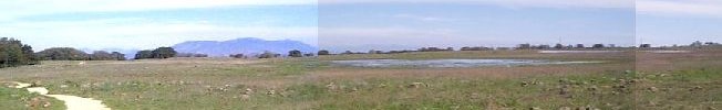
|
| 42 3/27 | 12.2" | 
|
| Note the different, but better, viewpoint below here | ||
| 57 4/11 | 11.8" | 
|
| 69 4/23 | 10.2" | 
|
| 74 4/28 | 9.0" | 
|
| 86 5/10 | 5.7" | 
|
| 111 6/4 | 0" | 
|
| 145 7/12 | 0" | 
|
| 227 10/2 | 0" | 
|