The 2019 Bruce Watts Census of Penstemon californicus, California penstemon
Bruce Watts, Tom Chester, and Lance Woolley

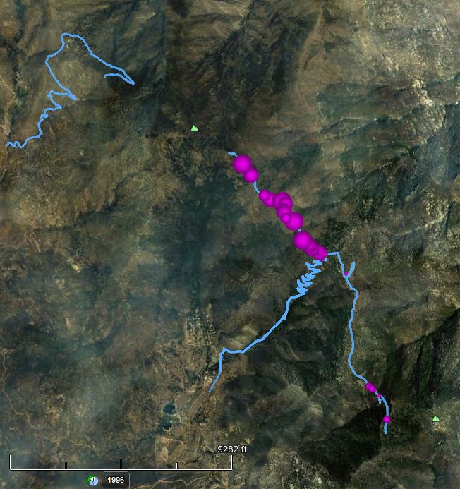
Fig. 1. The complete census of Penstemon californicus in Garner Valley in 2019, a total of 15,472 plants, shown on a Google Earth satellite map. As shown in the legend, the area of the pink ball roughly correlates with the number of plants found in the vicinity of each GPS point. The total number of plants is given for each of five areas outlined in white; the one just below center contains 7,259 plants, 47% of the total in Garner Valley. The light blue lines show the survey paths.

Fig. 2. Simulated aerial view of the densest part of the population of P. californicus, looking east, from Google Earth at an elevation of 6489 feet. Most plants are found on the northwest-facing slopes of the ridges. Click on the picture for a version showing the entire Garner Valley population as well as some of the population on the Desert Divide.
Table of Contents
Summary
Introduction
Habitat of P. californicus
Census Maps
Summary
Penstemon californicus is a rare plant in California and in Baja California, only known from scattered locations in Baja California, and in California known only from three nearby places: Garner Valley, where most of the population is found; the Pacific Crest Trail in the vicinity of the Cedar Spring Trail; and the ridge east of Toro Peak in the Santa Rosa Mountains.
Bruce Watts spent 21 days from 30 May 2019 to 5 July 2019, surveying all the plants in Garner Valley, finding a total of 15,472 plants. Plants were found only between Fobes Ranch Road on the north and Morris Ranch Road on the south. Most plants were found only in an area east of SR74 that was 1.74 miles north-south, and 0.79 miles east-west. There is a single disjunct population on the west side of SR74, in an area 0.1 miles north-south and 0.12 miles east-west. The edge of that population is 0.32 miles to the west of the edge of the main population. See the map shown in Fig. 1.
Introduction
See Penstemon californicus for an introduction to this species, which gives a number of photographs of it.
In 2019, Bruce undertook a census of Penstemon californicus in Garner Valley on 30 May. It took 21 days to survey all the plants in Garner Valley, since Bruce found a total of 15,462 plants there! Although this was five times the population of Boechera johnstonii, which took 11 days to survey, the survey for P. californicus only took twice as many days. Bruce estimated he hiked about 70 miles to do the survey in Garner Valley, which in some cases included the hike needed to get to the next area to survey.
There is a much smaller population of P. californicus on the Desert Divide. Bruce is still working on completing that survey, with the help of Lance Woolley. As of 6 August 2019, Bruce has hiked a total of 29 miles to do that survey.
Bruce gives his observations of the habitat of P. californicus in the next section. The final section gives maps showing the geographic distribution of the population.
See The 2016 Bruce Watts Census of Boechera johnstonii, Johnston's rock cress for a discussion about the similarity of vegetative plants of Boechera johnstonii and Penstemon californicus, making it important to do surveys of either species only when they are in bloom (see pix of the flowers of both species) or fruit. In addition, plants of Penstemon californicus and those of Eriogonum wrightii var. membranaceum can also be mistaken for each other.
Habitat of P. californicus
The California penstemon of the Quinn Flat/Garner Valley population can be described as shade loving. Plants grow on mostly north-facing hillsides in pebble fields; see Fig. 3 for its typical habitat.

Fig. 3. P. californicus plants growing in their typical pebble field habitat on a northwest-facing slope. The photograph was taken at 8:30 a.m. on 31 July 2019, with the direction to the sun beyond the top left of the picture. Click on the picture for a larger version.
Unlike the Boechera johnstonii that share the same habitat, P. californicus will grow on the valley floor if it is north facing or other shrubs or trees offer shade.
P. californicus in Garner Valley is closely associated with Adenostoma fasciculata, chamise, and in many areas only grows directly underneath the chamise plants which offer shade. It is not unusual to see several plants growing underneath a single chamise plant.
On south-facing hillsides, P. californicus will mostly grow on the north (shady) side of the chamise. If there are Jeffery pines growing nearby, the P. californicus plants are more likely be present and grow in flat areas on the valley floor.
P. californicus plants also do well when they grow out in the open flat areas with numerous shrubs and trees to offer shade. Basically they are in full light but get little direct sunshine. Plants grown under these conditions tend to be the largest and most floriferous. The largest plant I found during my survey was growing under these conditions, a 58 cm x 68 cm (23" x 27") monster with approximately 1,400 open flowers; see Fig. 4.

Fig. 4. The largest plant found in the Bruce Watts survey. Note the hiking poles at bottom left for scale, as well as the triangular ruler. The longest side on the triangular ruler is 7 inches (18 cm). The longest diameter of this plant is 68 cm, just beating the largest diameter given in the Jepson Manual for this species of 60 cm (twice the longest stem length of 30 cm). Click on the picture for a larger version.
Some plants do grow in full sun in pebble fields but they tend to be the smallest and have fewer flowers. Plants do not do well in areas with abundant grasses or on exposed hilltops. Artemisia tridentata is present in many of the areas where P. californicus grows, but it is rare to find P. californicus plants growing under sagebrush perhaps because it grows more erect without the low hanging branches of chamise.
The second population for P. californicus was along the Pacific Crest and Cedar Springs trails. The PCT plants threw out the rules of the lower elevation population and grew out in the open in full sun. The main reason for this is they are mostly growing in the Mountain Fire (July 2013) burn area. There are almost no shrubs to grow under and the plants seem to be confined to growing along the trail itself.
The PCT south of the Cedar Springs Trail junction has a small population of 110 plants strung out over 1.7 miles. The area north of the junction had 1,193 plants in the first mile. The main difference is the area north was in the burn area. This puts P. californicus in the "more abundant after a fire" column on the fire follower list.
Census Maps
These census maps are current as of 5 August 2019. The Garner Valley survey is complete. The Desert Divide survey is mostly complete, lacking only the Cedar Spring Trail north of the PCT, and the plants near Apache Peak.
Survey coverage maps:
Geographic Distribution of Penstemon californicus: