Analysis of iNat Observations of Plants of the Devils Slide Trail, San Jacinto Mountains
How complete is the iNat plant species list for the Devils Slide Trail?
I was curious as to how many of the plant species known from the Devils Slide Trail were posted at iNat. So on 4 June 2026 I downloaded plants that were within the boundaries of the Devils Slide Trail at iNat.
Before I downloaded the data, I reviewed the species list and found eight species that weren't actually on the Devils Slide Trail. Interestingly, four of those species (Hieracium albiflorum, Calystegia occidentalis, Calochortus invenustus, and Camissoniopsis sp.) were from a single 11 June 2013 trip that was posted on 11 December 2022. It appears that this observer misremembered which trail he was hiking that day. I removed those eight species by annotating those obs with either the correct species, if it could be determined from the obs, or by a higher-order determination, or by marking the location as inaccurate.
As of 4 June 2026, the resulting list had 2,946 observations of 133 species, with 231 identifiers and 252 observers for observations posted before 3 June 2026.
Note that if you click on the link after 4 June 2026, you might get different numbers if observations made before 3 June 2026 are deleted or added, or if determinations are changed on some obs. For example, on 5 June 2026, one observation had been deleted, perhaps as a result of comments I made on one, so there were then 2,945 obs of 133 species.
I exported that query, and was surprised that the exported version had only 2,917 observations. It turns out that obscured species weren't exported, which included 20 obs of Lilium parryi, 8 obs of Linanthus jaegeri, and 1 obs of Pentachaeta aurea. Adding those to the exported numbers makes a total of 2,946 obs, matching the Explore view.
Oddly, even though I know there are iNat obs of Streptanthus bernardinus from this trail, none are reported at the above link, nor present in the download.
I then cleaned the exported version to remove observations above Saddle Junction that were actually on the PCT or the Willow Creek Trail, and to remove observations in Humber Park west of trailhead. I left observations immediately south of the trail in case those were actually on the trail, but had position errors.
The cleaned dataset had 2,782 observations. I sorted those into unique species, combining observations determined to different levels for a single species, such as combining Gayophytum diffusum and G. d. parviflora.
After I compiled the unique species list, I found two additional bogus species that I had failed to catch earlier, as well as two species pairs, each present under two different names, that were the same species, such as Lupinus albifrons austromontana and L. excubitus austromontana.
Bryophytes are included in plants at iNat, so I tossed 29 observations of 10 mosses et al.
That left 2,646 observations of 113 plant species. Adding in the four obscured species not present in the download, the total was 117 plant species. In addition, there were 106 observations only determined to a higher order than species, which I did not examine.
I matched these observations to my Flora for the Devils Slide Trail, which contained 146 species as of 17 September 2020. Since that time, I've added six species to the Flora, for a total of 152 species.
I then had my answer. 77% of the species in the Flora of the Devils Slide trail are recorded on that trail at iNat, whereas 23% of the species in the Flora have not yet been posted at iNat. I'll go back through my pix and post as many of these as I can find.
Species observed on the Devils Slide Trail not posted from that trail at iNat
There are 35 species present in the Flora of the Devils Slide Trail that have not yet been posted at iNat as of 4 June 2026.
18 species are no longer present on the trail. Of those, 9 species were waifs only seen in a single year. The waifs were:
Bromus tectorum
Cirsium vulgare
Cryptantha muricata
Eriogonum davidsonii
Festuca microstachys
Gnaphalium palustre
Hulsea vestita ssp. callicarpha
Lactuca serriola
Nicotiana attenuata
Rafinesquia californica
The other 8 species were present for years, but then disappeared. We specifically search for these eight speciees on 19 June 2026, with the results given below. They were:
Acmispon heermannii var. heermannii - last recorded 6 July 2011; not seen on 6 July 2020. Five plants were present in one location at mile 0.38, but may have disappeared. On 19 June 2026 we found two plants at mile 0.38, and five plants at a new location at mile 0.17!
Boechera repanda (Yosemitea repanda) - last recorded 7 June 2014; all plants gone on 3 July 2015. These plants were seen for years at one spot. Their numbers fluctuated a lot, since they were periodically attacked by gophers. A detailed history of the numbers is given in the last observation of these plants. All plants were still missing on 19 June 2026.
Calochortus invenustus - Ths plant just west of the Munchkin Lemon Lily was last recorded 15 July 2019; not seen on 6 July 2020. Plant was still missing on 19 June 2026.
Calyptridium monospermum - last recorded 7 June 2014; not seen on 6 July 2020. There are tons of plants of this species in Tahquitz Valley, but there used to be a population on the last segment of the Devils Slide Trail, just west of Saddle Junction. I haven't seen those plants for years. I searched for them on 6 July 2020, and on some subsequent trips, and didn't see them. Plants were still missing on 19 June 2026.
Eriophyllum confertiflorum var. confertiflorum - last recorded 6 July 2020, and might still be present, even though it has been unrecorded in the years since. No plants were found on 19 June 2026.
Monardella australis ssp. australis - Five plants in two nearby locations were seen above the trail beginning on 2 September 2003, which were still in good shape in 2011 and 2020. But they gradually withered in subsequent years and did not appear to be there in 2025 and 2026. A patch of 15 plants were spotted 20 feet below the uppermost seep area on the trail on 6 July 2020. I haven't checked whether these plants are still present or not. No plants were found on 19 June 2026 at any of their locations.
Perideridia parishii - first observed on 14 July 2006, 30 feet below the trail, at the bottom of the Carex senta patch at mile 2.35, and was not found on a search for it on 6 July 2020. It appears I never photographed it when it was present. No plants were found on 19 June 2026.
Stipa occidentalis var. pubescens - only one plant seen on 26 July 2011 just west of Saddle Junction. The plant was not seen in the 6 July 2020 survey. No plants were found on 19 June 2026.
I've now posted my pix of seven of these eight species at iNat. Perideridia parishii is the only one for which I don't have photographs of.
At least two additional species, Veratrum californicum and Angelica capitellata, were in the wet seep above the Munchkin Lemon Lily back in 2003, but a gopher took them out when the seep dried up. I removed those from the guide since I only observed them as I was creating the plant guide to the Devils Slide Trail, and they were missing before I finished the first guide. See The at-least-24 year old Munchkin Lemon Lily on the Devils Slide Trail.
5 species have only been seen off-trail, making them more difficult to spot:
Koeleria macrantha
Monardella nana
Muhlenbergia rigens
Orobanche fasciculata
Phoradendron juniperinum
The remaining 12 species are all on-trail and still present:
Asclepias eriocarpa
Carex abrupta
Carex heteroneura
Claytonia rubra
Deschampsia elongata
Epilobium ciliatum ssp. glandulosum
Juncus longistylis
Mimulus primuloides var. primuloides (Erythranthe primuloides)
Poa fendleriana ssp. longiligula
Poa pratensis ssp. agassizensis
Silene verecunda
Penstemon labrosus
Six of these species are grasses or sedges, which most people don't pay attention to.
The Asclepias eriocarpa is abundant at two spots at the beginning of the trail, but these plants hardly ever bloom.
The Silene verecunda is erratically present at Jolley Spring. It was absent for some years, and I either declared it to be dead in a previous version of the guide, or I was about to do that, when it appeared again!
The Epilobium ciliatum glandulosum may be present in the iNat obs, but they do not distinguish between the two subspecies of it.
Analysis of locations for iNat obs for the Devils Slide Trail
In the process of comparing the iNat species with the species in my Flora of the Devils Slide Trail, it also became apparent that there were some other interesting analyses that could be done with the iNat data.
For the following plots, I included the mosses since I didn't bother removing their observations from the cleaned dataset. These plots therefore include a total of 2,646 + 29 + 106 = 2,781 observations.
Fig. 1 shows a map view of those observations. That map view shows that iNat observations cover almost the entire trail fairly thoroughly, and delineate the trail quite well. The section of trail with the fewest observations is, not surprisingly, the final section before Saddle Junction, where the diversity is low, and even iNat hikers are anxious to get to Saddle Junction.
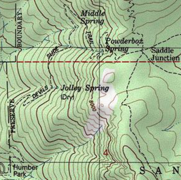
For reference, see also the topo map of this trail.
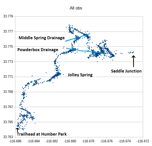
Fig. 1. Map view of 2,781 iNat observations of plants and mosses as of 7 June 2026, with springs and drainages labeled. Note the concentrations of observations to the wet areas, as expected. But also note the many observations all along the trail, defining the trail quite well in most areas. The section of trail with the fewest observations is, not surprisingly, the final section before Saddle Junction, where the diversity is low, and even iNat hikers are anxious to get to Saddle Junction.
Observations that plot outside the well-defined trail are ones with large position errors, except for some near Humber Park, where it is possible to explore off-trail a bit. Some of those points along the trail above Humber Park are ~800 feet from the trail. In general, the terrain is so steep that it makes it nearly impossible to go more than 20 feet or so off-trail. But GPS positions are not infrequently off by several hundred feet due to the challenging GPS conditions on the Devils Slide Trail, with dense forest cover in many places, and exposed rocks that produce multipath errors in the GPS signals.
Fig. 1 also shows that iNat observations are concentrated along the wet drainages, as expected since 39 species are only found in the wet drainages. Wet drainages also have more plants of almost all species as well, and observers stopped at the wet drainages are more likely to record those species too.
To see how well the iNat obs of the 39 wet area species are confined to the drainages, Fig. 2 shows a map view of those iNat observations.
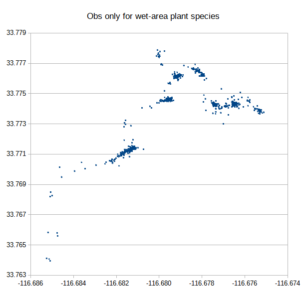
Fig. 2. Map view of 933 iNat observations of plants that grow in wet drainages, as of 7 June 2026. The vast majority of these observations plot in the wet drainages, but there are scattered observations that plot outside of wet drainages. That is in part because there are a few seeps that are not in the drainages, that contain some wet area species. In particular, there is a seep a bit above Middle Spring, and another one above the switchback above Middle Spring. In addition, a small number of observations are of wet area species seen at a distance below Middle Spring. The other observations are ones with position errors.
Fig. 2 shows that although those wet area species are highly concentrated to the wet areas, there are scattered locations for them outside of drainages. Essentially all of these are due to position errors.
To investigate those position errors in more detail, Fig. 3 gives the map view of the iNat observations for a single species, Rhododendron occidentale. Incorrect locations are marked with a red circle. A few of those locations have an associated high uncertainty, but the majority of them do not.
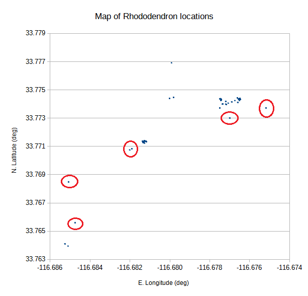
Fig. 3. Map view of 71 iNat observations of Rhododendron occidentale, as of 7 June 2026. Incorrect locations are marked with a red circle. The two locations at bottom left are from the creek just below Humber Park.
I can use the Rhododendron observations from Jolley Spring to get the positional accuracy of those iNat obs, since there are only a few Rhododendron plants there, and they are all close together. These observations are the ones in the middle of Fig. 3, with two locations that are marked incorrect. Ignoring those two observations with large position errors, there are 22 iNat obs of these plants. The standard deviation of those points is 28 feet (8.5 m), which is pretty good at San Jacinto Mountain. The two observations with bad locations are 376 and 324 feet (115 and 99 m) away from the mean of the others. Such large errors are often due to phones not updating their GPS location, and retaining a previous location. They also occur even for GPS units that are continually updating, when multipath errors degrade the GPS signals.
Fig. 4 shows a map of the 1,849 iNat obs of species that are not wet area species. This map looks pretty similar to the map that includes the wet area species. Wet drainages have more plants of almost all species, and observers stopped at the wet drainages are more likely to record those species too.
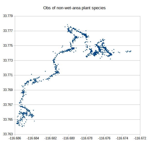
Fig. 4. Map view of 1,849 iNat observations of species not restricted to wet areas, as of 7 June 2026.