Flora of the southern Boy Scout Trail Area, Joshua Tree National Park
This flora was compiled from vouchers, iNaturalist observations, and from "five-plus" days of fieldwork in November 2017, after this area had received monsoonal rain eight weeks earlier on the weekend of 10 September 2017.
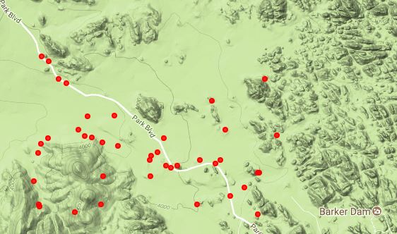
Fig. 1 shows the southern Boy Scout Trail Area, along with areas we surveyed in November 2017.

Fig. 1. Topo map showing the southern Boy Scout Trail Area in the NW part of Joshua Tree National Park. Surveyed areas are shown by the solid red and solid green lines. Only the area covered by blue and green solid lines, with blue diamonds along them, north of Park Boulevard, are included in this checklist for the Boy Scout Trail. The blue diamonds are GPS locations for species from our surveys.
Click on the image for a larger map.
Fig. 2 shows the locations of species observations from voucher, iNaturalist, and our surveys.
Voucher Locations | 
iNaturalist locations |

Our survey species locations |
Our survey paths |
| Fig. 2. Species locations from vouchers, iNaturalist, and our surveys. Click on the pictures for larger versions. | |
The fieldwork on 3 November 2017 was along the first part of the Boy Scout Trail, and a short hike south of the Quail Springs Picnic Area, by Tom Chester, Walt Fidler, Mike Crouse, Michael Charters and Bill Bulger.
On 9 November 2017 Michael Charters returned here, and botanized the trail to Willow Hole. On 10 November 2017 RT and Shaun Hawke also botanized the trail to Willow Hole.
On 26 November 2017, Tom Chester, Walt Fidler, Nancy Accola and Joan Barger botanized from the trailhead to Willow Hole. Walt Fidler botanized the area the previous day as well.
There were 172 taxa in the combined list from all of these trips.
See Michael Charters' Photo Gallery from this trail, showing pictures of 83 taxa, and Joan Barger's 107 photographs from 26 November 2017.
A separate page gives a list of the species observed in bloom on 3 November 2017, along with some pictures of some of the plants in bloom.
Georeferenced vouchers were searched at the Consortium of California Herbaria on 1 November 2017, in the rectangle from 34.03 to 34.12° N. Latitude, and -116.23 to -116.17° E. Longitude. The voucher of Quercus turbinella was taken as a voucher of Q. cornelius-mulleri, since the name of Q. turbinella was misapplied to these plants before the recognition of Q. cornelius-mulleri. No attempt was made to check for reasonableness of most of the determinations. 269 vouchers were retrieved, of 145 species.
Subsequently, vouchers from north of 34.07° N. Latitude were removed from the list, in order to restrict this checklist to the part of the Boy Scout Trail Area from the trailhead to Willow Hole. 128 taxa from vouchers remained after restricting the area. Of those 128 vouchered taxa, 71 were ones not seen in our field surveys.
iNaturalist was searched for roughly the same area. Five species were removed from the list from iNaturalist:
- "Opuntia acanthocarpa" was tossed as being out of range; see Opuntia acanthocarpa var. coloradensis.
- "Baileya multiradiata" was a misdetermination of B. pleniradiata.
- "Salvia pachyphylla" was a misdetermination of S. mohavensis.
- "Boechera pulchra" was a misdetermination of Astragalus lentiginosus.
- "Brassica tournefortii" was probably a misdetermination of a Sisymbrium species.
INaturalist observations contributed 48 taxa not present in the voucher flora. 41 of those taxa were seen in our fieldwork, with 7 of those taxa being the only record of a species in this area.
The reader can see the pictures of the iNaturalist species, and some of the vouchered species, totaling 126 species, at iNaturalist. This link uses the "Place" I've defined called the Boy Scout Trail Area.
One additional taxon, Eschscholzia papastillii, was added to the list since the range map for this newly-defined species (Still 2014) includes this area, and another, Astragalus coccineus, was added from a photo from a Sierra Club trip here in spring 2017 kindly sent to Michael Charters by Ginny Herringer.
The total checklist for the Boy Scout Area contains 252 taxa.
Basic information about the checklist presentation and links:
- Notes on the Scientific Names Used At This Site and
- Information about the links from the Scientific Name and Common Name.
An asterisk before the Common Name indicates a non-native taxon.
The column with header #V gives the number of vouchers found in the southern Boy Scout Trail Area, as delineated above. Species found only at Willow Hole in vouchers are marked with WH instead of the number of vouchers. If there were no vouchers of a taxon, but it was given in iNaturalist, the column contains iN. As mentioned above, one species, Eschscholzia papastillii, was added from a range map, and has IR in this column, standing for In Range, and another species, Astragalus coccineus, was added from a Sierra Club trip in spring 2017, and has SC in this column.
The column with header #Pls gives the minimum number of plants, up to a maximum of 99 plants for each species, in the area of the Boy Scout Trail observed on 3, 25 and 26 November 2017. The number of plants do not include plants seen near the Quail Springs Picnic Area. A few species found only by Michael Charters, or RT and Shaun Hawke, have no abundance estimate given, and are noted with MC or RT in this column. In many cases both of them reported a species, so we arbitrarily assigned it to one or the other. One additional species found so far only near the Quail Spring Picnic Area, Erigeron breweri var. porphyreticus, is noted with QS in this column.
One species, Chenopodium fremontii, has a "~" on its number of plants, indicating that we are not certain of the determination. We took it as that species in the field, but did not carefully examine the plants to distinguish it from C. album, which is vouchered from there.
Although the checklist lists both Astragalus lentiginosus var. fremontii and var. variabilis, we suspect the plants here are actually intermediates between the two varieties, and hence there is only one taxon here. The plants are then artificially split into those two varieties, which are separated solely by the length of the keel and the density of hairs on the fruit. But this is just a suspicion; we have made no measurements to confirm this.
Since this survey was not done in the spring of a good year, most of the annuals and some of the perennials were either not observed at all, or have much lower numbers recorded than would have been seen in such a spring survey
Version for printing, without other text on this page: html (8 pages) or pdf Clickbook booklet (2 double-sided pages). (See printing instructions for an explanation of these options)
Voucher data provided by the participants of the Consortium of California Herbaria (ucjeps.berkeley.edu/consortium/; 1 November 2017).