The 2007 Fallbrook Fire: A Fire In A Suburban Rural Landscape
How The Winterwarm Area Was Saved
Table of Contents
Introduction
Overview Of The Landscape
Wind Conditions
How Wind-Driven Fires Spread, and How Fires Are Extinguished
Timeline Of The Fire
Pictures Of The Southwest Flank When The Fire Was Out
Analysis Of The Fire
Speed Of Travel Of The Fire, And Putting It Out
The Major Source Of Fuel For The Fires
The Most Dangerous Locations For Your House
The Importance Of Proper House Construction, Flammable Items Near Your House, and Fire Engine Access
Introduction
The 2007 Rice Fire in Fallbrook / Rainbow was essentially the worst-case scenario for a fire to threaten the Winterwarm Area of Fallbrook, where I live, for three reasons:
- The fire began well after a number of other major fires had begun, so resources to fight the fire were extremely limited. If there had been no other fires first, the fire would have been contained much earlier.
- The fire began 6 miles to our northeast, with strong Santa Ana winds blowing from that direction, driving the fire straight toward the Winterwarm Area.
- The winds were unusually strong for a Santa Ana, with maximum gusts of 50-70 mph when the fires were only a few miles from the Winterwarm Area.
This page tells the story of the initial spread of the fire to the west, and how the fire on its southwest flank was extinguished, as deduced from observations of burned areas where the fire was put out, and discussions with the Riverside County firefighters who fought the fire in that area.
Much of the analysis here is only of the southwest flank of this fire, and should not be generalized to other flanks of this fire, which have different landscapes. However, some of the lessons are more general, such as the most dangerous locations for a house and the importance of defensible space, fire engine access, and proper home construction.
I did not set out with the goal of telling this story. Instead, the story dropped into my lap when Linda Prager kindly invited me to see where the fire was put out, and by chance, those firefighters were called in to put out a flare-up that occurred during my visit. I learned several things in that visit and from those discussions, and several other things were really driven home to me. I thought a larger audience might like to hear this story.
Although I am a scientist, I am not a fire expert, and hence would appreciate any feedback from fire professionals on the conclusions I have drawn. This page has benefited from feedback from a number of fire experts in southern California.
Overview Of The Landscape
The following map shows the area near where the Rice Fire began and where it was stopped on its southwest flank:

In the map above, a long blue arrow begins at a point in Rice Canyon south of the fire origin, and ends at the Winterwarm Area in the lower left. The blue line is oriented roughly along the direction of the wind. Elevation contours in the above map are in meters; the next map gives them in feet.
The following plot shows the elevation profile versus distance along that blue line. In the plot, distances are measured from the Winterwarm area, in the reverse of the arrow direction, so that west is on the left side of the plot. This makes features line up from left to right with the map above.

The area here is roughly divided into north-south ridges and drainages, seen clearly in the map and elevation profile above. The ridges are higher to the east, ending with Palomar Mountain at 6140 feet elevation, and vanish at the coast. The drainages run into the San Luis Rey River, which flows roughly east to west at the bottom of the above map.
A blow-up of the rectangular area outlined in black on the above map is shown in the next map, which shows elevation contours in feet:

The middle portion of the same blue arrow is shown in the above map. The location of the Valley Oaks Mobile Home Park is noted, as is the location from which the following photograph was taken. The approximate area shown in the photograph below is outlined with light black lines in the map above. The ridgeline in the picture, that roughly parallels Wilt Road, is traced in blue.
A photograph of where the southwest flank of the Rice Fire was put out is given below:
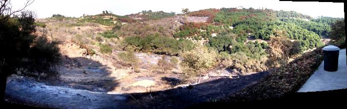
The non-burned groves of avocado trees at upper right, and the scattered homes at the upper middle left (seen better in the picture below) surrounded by irrigated landscape, are typical of what the burn area looked like before the burn. Several open areas covered with white ash were totally burned in the fire. This photograph will be discussed in detail below.
Virtually the entire area along the full length of the blue line is a human landscape, devoid of natural vegetation except for scattered coast live oaks (Quercus agrifolia). Except for extremely small pockets elsewhere, the only significant patch of natural vegetation is on the portion of Monserate Mountain south of the blue arrow. Although this natural vegetation may have contributed to the initial spread of the fire, its influence was negligible west of I-15.
Furthermore, it is unlikely that the scattered coast live oaks contributed to the fire here. In fact, coast live oak is not only resistant to fire, it helps suppress fires by putting out embers in its canopy. (However, I note that several fire professionals strongly feel that unmodified riparian drainages, including ones with coast live oaks, often act as fire conveyances. If a fire is intense enough, almost anything will burn, including coast live oaks.)
The landscape consists mostly of residential lots 1-10 acres in size, along with a few commercial groves, nurseries and golf courses, all with above-ground propane tanks to supply them with heating gas. Many of the residential lots also contain groves, and most of the groves are irrigated. There are two exceptions to the low-density rural development: the Valley Oaks Mobile Home Park, containing 212 mobile homes in very close proximity, and high-density condominiums at Pala Mesa Resort.
My two acre yard is probably typical of many residential lots that do not have groves. It consists of well over 90% non-native species, including ornamentals, fruit trees, vegetables, and many Mediterranean weeds. The non-irrigated areas are almost 100% non-native weeds such as Crete weed, bur-clover, red brome, foxtail barley, and filaree; the native coastal sage scrub and chaparral were long ago removed by bulldozers, tractors and other disturbances.
The fire district requires these non-irrigated areas to be mowed or tilled before fire season begins, since these dry annuals are extremely flammable and burn very rapidly once ignited. In both respects, such patches of non-native annuals are a much-bigger fire danger than native plants. In fact, you can almost count on there being several small fires in Fallbrook per year ignited by this mowing.
The vegetation along many of the roads consists of highly-flammable non-native species such as fountain grass, Russian thistle, and tropical horseweed (Conyza floribunda).
Thus the story of the fire in this area is of interest since the natural landscape was not a factor. (The natural landscape was definitely a factor in other areas burned by this fire, such as at Red Mountain and north, at the top of the map, but those areas are irrelevant to the story told here, and weren't burned until after the fire was stopped on its southwest flank.)
It is important to note that fuel available to be burned by fire from human structures nearly always dwarfs the fuel available from vegetation. Rehm et al 2002, of the Fire Research Division, Building and Fire Research Laboratory, National Institute of Standards and Technology, in their report Community-Scale Fire Spread, state:
The heaviest likely fuel load in the forest is less than the lightest load for a structure.
At a typical Fallbrook density of one house per acre, their tables show that the fuel load from houses is on the order of 100 times more than the fuel load of a forest. Analysis of the recent Lake Tahoe fires confirmed that this fuel load matters; cabins were a major factor in the spread of that fire even though the cabins were surrounded by trees. The fuel load of any non-forest natural vegetation in southern California is no larger than that of a forest.
We've all seen pictures of the subdivisions in Poway or Rancho Bernardo where many houses have burned. Most of those homes were undoubtedly set on fire by fires from other houses, either by the direct heat and flames of their immediate neighbors or embers from houses blocks away.
Wind Conditions
The wind, of course, was the major factor in the spread of this fire. Fires can always be put out if there are no strong winds; fires can almost never be put out if there are strong winds.
The wind speed on Monday, 10/22/07, and Tuesday, 10/23/07, as measured from the WeatherCurrents Station in the Winterwarm Area at 680 feet elevation, is shown in the following plots:


In the above plot, the "wind" is the instantaneous wind speed measured every minute; the "gust" is the maximum wind speed recorded in the previous minute. Note that the scale in the top plot is truncated at 30 mph to show the general behavior of the wind; there are a number of wind values larger than 30 mph that go "off-scale" in that plot (see below).
Winds are often very local, so there are no guarantees that the wind measured elsewhere in Fallbrook was identical to these measurements. However, it is quite likely, since these Santa Ana winds were a widespread event, that the winds in nearby locations are correlated strongly with these measurements, perhaps with time offsets in some cases.
The fire was caused by downed power lines around 4 a.m., which may have been toppled by strong winds in Rainbow that weren't present in the Winterwarm Area. Using the Winterwarm winds as a guide, the fire was probably initially spread by strong winds from 4:50 to 5:10 a.m. and then again from 10 a.m. to 12:30 p.m. There was only a brief letup in the wind for an hour before it began to pick up again.
The main wind event was 3-9 p.m. on Monday, with a brief secondary event at 11 p.m. The wind speed essentially never went below about 10 mph between 6 and 9 p.m. Monday night; the gusts never went below about 15 mph. The median wind speed between 6 and 9 p.m. was 14 mph; the median wind gust was 21 mph. The maximum wind gust was an amazing and very unusual 70 mph (off-scale in the above plot). Gusts over 40 mph were recorded in 21 different one-minute intervals between 5:19 and 10:23 p.m., with another one recorded at 10:46 p.m.
The winds essentially died down completely soon early Tuesday morning, and were essentially zero thereafter. This is very different from locations just 12 miles away. For example, Temecula continued to record strong winds from the northeast most of the day Tuesday, with gusts of 15-25 mph until after 5 p.m.
If the winds in Fallbrook had continued, it is quite possible that much more of Fallbrook would have burned. This was the very-plausible motivation for the evacuation order for all of Fallbrook. Such winds could cause fire to go from I-15 to the coast in less time than people could evacuate. (It took an average of three hours "driving" time for people to travel from Fallbrook to the coast on Monday afternoon, a trip that normally takes a half hour.)
How Wind-Driven Fires Spread, and How Fires Are Extinguished
In order to make sense of the rest of this page, one needs to understand how wind-driven fires spread. Many people have the idea that a fire starts in one spot, and then burns in a continuous pattern away from that spot. For example, in a uniform field of wheat, in this model each wheat plant would only burn when the fire perimeter reaches it.
Fires in southern California driven by high winds don't burn like that. Embers from fires driven by high winds can start fires up to 1.5 miles away from the "front" of the fire. The maximum distance of "1.5 miles" is the canonical wisdom; it apparently is larger in some cases. A home on Queenston Drive in Escondido burned on 22 October 2007 when an ember from "2 miles away" landed on its wood shake roof. This is a minimum distance, since the fire never burned closer than two miles to this house. (San Diego Union Tribune, 1 November 2007, NI-1)
Those spot-fires spread in the direction of the wind, and in turn can start new spot fires in whatever direction the wind is blowing there. Everytime you hear that a fire "jumped" the freeway, this process was at work, since the concrete freeway doesn't burn. A typical 8 lane freeway width is 400 feet, less than a tenth of a mile.
If the wind is blowing consistently in one direction, the fire can essentially leap-frog its way across the landscape, and spot-fires can burn backwards (as well as forwards) and even put out the previous "fire front", replacing that old front with their own.
Worse, strong and/or large fires create their own local wind, since the heat causes the air to rise, which tries to draw in air from all directions. The local wind pattern produced by a fire can be very erratic, since the fire itself burns in a complex pattern, and also burns hotter in some places than in others.
The Fallbrook fire fit this pattern precisely. John Buchanan, the public information officer for North County Fire Protection District, said on Monday that the Rice Fire in Fallbrook appears to be destroying homes in an unpredictable pattern. The fire is acting like a tornado, taking out homes outside of its path of destruction, probably from hot embers (North County Times 10/23/07).
Aerial attacks on wind-driven fires are virtually useless. The erratic winds will cause most water or fire-retardant drops to miss their target, and disperse them so much that they don't do any good even where they land. Even if the drop hits its target, it hardly matters; the fire has already spread beyond that point. It is also very unsafe to fly in such conditions, and foolish to even try when the chances of success are almost zero.
The two main tools used by firefighters on the ground, constructing containment lines via human labor or bulldozers, and backfires, are also almost useless against wind-driven fire. It is impossible to construct a containment line in front of a fast-moving, wind-driven blaze, since there is no time to create one. Backfires can't be set if the wind never shifts to drive the backfire into the advancing flames. (A containment line is a cleared area that deprives the fire of fuel, and backfires are usually set on the fire side of the containment line to make the containment line much wider. Backfires can sometimes be used without constructing a containment line if the wind conditions are right. A backfire "burns back" to the wildfire and puts it out by removing fuel from its progress.)
The third tool is to try to actually put the fire out using water or fire-retardant, either from the ground or from the air. This is a puny tool compared to the two main tools, and takes much more time and effort than using backfires.
Fighting fires in human landscapes is much harder than fighting fires in natural areas, because firefighters cannot use their two main tools. It would be very unpopular to bulldoze a block-wide line of luxury homes in order to make a firebreak, and then set fire to the homes and landscapes inside the firebreak to burn back to the active fire.
All firefighters can do to fight wind-driven fires in human landscapes is to try to protect as many structures as they can safely protect with ground crews, and wait for the wind to stop so the fire can actually then be put out, usually with the considerable aid of aerial attacks.
Note that "defensible space", the clearing of flammable vegetation, woodpiles, etc. around one's house, can not prevent embers from reaching your home during a wind-driven fire, since those embers come from far away. A clearance of 100 feet is insignificant compared to the 8000 feet embers can travel. We all now know of many examples of fires jumping freeways that are a minimum fuel break of 400 feet for embers blowing perpendicularly to the freeway direction, and are even longer breaks for embers blowing in other directions.
However, if you have defensible space, it has two beneficial effects. First, it will decrease the number of embers reaching your house, since your immediate landscape will not be contributing local embers. Second, it is more likely that firefighters will try to protect your home during such a fire.
Of course, defensible space is very important when the wind is not a factor, and can prevent flames and embers from ever reaching your home.
Timeline Of The Fire On Its Southwest Flank
This timeline has been reconstructed from news reports, and online postings by people reporting what they saw at definite times. The online postings were an extremely-rich resource; see Online community comes to the fore during fires for the interesting story of how readers hijacked the comments section of stories of the North County Times and turned it into a constantly-updated news source.
The Rice Fire in Fallbrook / Rainbow was first reported at 4:16 a.m. on Monday, 10/22/07. It was later traced to a single power pole in the 1500 block of Rice Canyon that went down around 3:30 a.m. When firefighters arrived, the fire had already grown to about five acres, and was too large to suppress due to the dry and windy conditions, according to Fire Chief Steve Abbott (North County Times, 10/29/07, A9).
Firefighters evacuated nearby residents, and then tried to stop the fire at I-15 (see picture). But with only seven fire engines, and strong winds, the fire jumped I-15.
There are apparently-conflicting reports about when the fire jumped I-15; however, both could be correct and referring to different portions of the fire.
A Cal-Fire report on the San Diego County Emergency Page said it jumped I-15 at 2:36 p.m. The winds were reported to be 40 mph when the fire jumped I-15; this may be have been the "leading edge" of the winds that arrived a bit later in the Winterwarm Area.
De Luz Volunteer Fire Department Chief Mike Manchor, in a North County Times article on 11/4/07, said when his crew arrived at the Valley Oaks Mobile Home Park "around 10 a.m.", the fire was at the intersection of Reche Road and Old Highway 395, less than a mile east of the part, on the west side of I-15.
The Valley Oaks Mobile Home Park was in full flames in mid-afternoon, when it was filmed by Channel 7. Three engines with ten firefighters were assigned to home protection in Valley Oaks, out of the total of 50 firefighters fighting the entire fire. Two of the engines were from the De Luz Volunteer Fire Department; the third, with four firefighters, was from the North County Fire Protection District.
The firefighters fought and tried to save the Valley Oaks Mobile Homes, putting their own lives and health at considerable risk, not only from fire, but from toxic fumes from the burning homes, as well as deafening explosions from the numerous propane tanks there. Despite the wind, there was one successful air drop along the eastern edge.
However, saving most of the homes proved impossible due to wind, the high density and the high flammability of those homes. Every ten minutes another home would go up in flames. The smoke was so intense that despite the full sun of mid-afternoon, it was like the middle of the night, with visibility of only 10-15 feet.
One report said that some homes burned even after the firefighters thought they had saved them, as the swirling winds brought the fire back to those homes. Another report said that mobile homes burn like balsa wood, and it was nearly impossible to put the fires out there. Some of the homes were actually melting due to the heat from the burning homes surrounding them.
Conditions were so dangerous that early in the battle, the decision was made to evacuate the firefighters. Unfortunately for their own safety, but fortunately for some homeowners, the De Luz firefighters never heard that order, and continued to fight the fire there with just six firefighters, one firehose connected to a fire hydrant, and garden hoses.
Nonetheless, by 5:30 p.m., firefighters were able to save exactly half of the mobile homes, mostly in the southern area of the Park, and the fire at the Park were mostly out. See Tony Shin's report on the 6 p.m. Channel 7/39 news for video of the Park burning earlier in the day, and smoldering during his live report. The De Luz firefighters finally left well after sunset, and had to exit along roads that were becoming fully engulfed by the fire.
At some point during the day Monday, Riverside and Sonoma Counties, along with 170 California Department of Corrections inmate firefighters from Georgetown, CA, provided desperately-needed assistance in fighting the entire Rice Fire. There were 12 fire engines fighting the southwest flank of the fire as of Monday evening. There were almost surely additional fire engines at the other flanks of the fire.
At 5:30 p.m., buildings were burning just south of the Mobile Home Park, and homes were burning along Reche Road to the west of the Mobile Home Park, reaching Camino Zara, just west of Wilt Road. (See picture taken at 5:30 p.m. of the larger cloud of smoke from homes burning along Reche, Wilt, Ranger and Yucca Roads on the left, and the smaller plume from the Mobile Home Park area, taken from three miles to the southwest.) Tony Shin reported that just before 6 p.m. they had driven along Reche Road to the west, saw several homes burning, and turned around when it looked unsafe for them to continue driving west.
The firefighters tried to make a stand at Wilt Road, but the fire blew past them. One engine was nearly taken out by an exploding propane tank in that area.
The plan quickly changed to making a stand at Gird Road.
Sometime between 6 and 8 p.m., the first embers reached almost to Gird Road, and the crews of the 12 fire engines began putting out tree fires and vegetation fires near homes off Gird Road. The area just east of Gird Road became the active part of the fire sometime between 8 and 9 p.m. (See picture of the fire front at 8:17 p.m. immediately east of Gird along Nuestra Drive at the north end of the Golf Course.)
At 9:22 p.m., as seen from Via Del Robles in the Winterwarm area, the Gird Road area was a "wall of flames". At 11:00 p.m., houses were burning east of Gird Road from Reche Road down to at least Laketree Drive, and perhaps as far south as Oak Cliff Drive which meets Gird Road at the south end of the golf course. Reports said a lot of propane tanks blew.
Interestingly, while all of this fire was going on, a 10:30 p.m. report said that people 0.6 miles away, on Reche Road very close to Gird, saw nothing near their home to be concerned about. Most of the fire activity was apparently behind a very small ridge between them and the fire.
By 11:30 p.m., the firefighters had the upper hand. Nancy, at the Jeffries Ranch area of east Oceanside, was able to monitor most of this area. At 11:33 PM, she wrote:
Looks like it's dying down. I can't believe the difference from an hour ago! There is almost no glow from the hills now, where there was a long ridge of flames and huge hot spots in 3 or 4 different spots an hour ago. I can see one large hot spot only now.
The "hot spots", of course, were almost surely burning homes.
The firefighters won; they successfully put out this flank of the fire, and saved the Winterwarm Area. All of us in Fallbrook are deeply grateful for the brave actions of these firefighters.
(Note that no one ever expected that the entire Rice fire would be put out at the same time; this action was to try to stop the fire's movement to the west at this location, and it succeeded. Other firefighters were battling the other flanks simultaneously.)
Pictures Of The Southwest Flank When The Fire Was Out
The following is a larger version of the central part of the picture shown above, with areas touched by the fire marked:

See also larger version of the entire previous picture.
Although the fire was clearly pretty extensive in this area, almost none of this damage can be seen from Gird Road, even though there are burned homes and landscapes within 1000 feet of Gird Road.
Note that the burn is not confined to a single large area, with unburned area outside of that area. Although there was fire over about 50% of the area in the photograph, the burned area consists of many smaller patches, each probably started by embers from the advancing fire.
The difficulty of stopping the fire at Wilt Road is apparent in this picture. Note the many burned areas that probably began as embers driven by the wind over Wilt Road.
The only natural vegetation in this picture is a line of coast live oaks along the drainage that goes from left to right. Note that the leaves have all turned brown, but none of them burned. The leaves probably turned brown from the heat of the vegetation burning on the closer side of the valley, but those oaks did not fuel the fire with their canopy. Of course, if there was any leaf litter under the oaks, the fire may have traveled along the ground surface, just as happens under avocado trees. (See also zoomed picture.)
The same pattern of browned leaves is seen on numerous patches of avocados on most prominently on the right of the picture, but many of those patches are next to green trees. This browning is probably due to heat from burning leaf litter underneath those trees; avocado trees typically have a thick layer of very dry leaves under them.
Firefighters almost surely were responsible for putting out all of these patches of fire, especially when they got near homes.
There is a burned home within the leftmost red rectangle along the ridgeline (see zoomed picture). It even had a steel frame; several of those steel studs are still standing. The structure on the left is the garage of that house. This house presumably burned in the usual manner; an ember got into the attic and set fire to the paper backing of the insulation. It isn't known whether the ember came from the burned vegetation below the house, or from a fire on the east side of Wilt Road. I suspect the latter, since the vegetation is mostly browned below the house, not burnt, and hence was probably browned from the house fire.
There is a nearby burned house that is to the right and out of sight in the above picture. The location of that house is given in the map above, labeled "Location of burned home". In the above picture, you can see the burned area heading up slope to that house. It isn't known whether the house ignited from flames traveling up that slope, or whether it was ignited by embers from more distant fire.
That house had three strikes against it, almost guaranteeing it would burn in any fire that approached it:
- The wooden walls were easily ignited by the abundant embers, from the flames traveling up the steep slope, or simply from the heat of the fire from surrounding areas.
- The house was located on top of a knoll, with steep slopes on all sides. Such locations are basically indefensible since firefighters can be trapped by fire on top of the knoll with no means of escape. No one should risk their lives to defend any home located in such an area.
But the home of course did have incredible views from being on top of that knoll.
- The driveway of the home was too narrow and winding to be negotiated by fire engines.
Analysis Of The Fire
Speed Of Travel Of The Fire, And Putting It Out
Surprisingly, the speed of travel of the fire was always much less than the wind speed, even though this was a wind-driven fire. In fact, during the fire I was always very surprised at how slowly it was traveling, since many other fires in southern California advanced much more rapidly.
The travel time of the fire between I-15 and Wilt Road, and between Wilt Road and Gird Road, was only 0.3 mph, much less than the wind speeds of 10-25 mph at the time as measured in the Winterwarm Area. This speed is only 30 feet per minute, or 1 foot every two seconds. (Of course, it is misleading to think of the fire as actually creeping along at that speed; as mentioned above, the fire grows by leaps.) In contrast, parts of the Cedar Fire of 2003 in San Diego County spread at 16 mph, comparable to the average wind speed at the time.
The slow spread of the Fallbrook fire was undoubtedly due to the landscape in which the fire traveled. Two features of the Fallbrook landscape helped slow down this fire. First, much of the landscape is irrigated, and thus is much harder to ignite than an unwatered landscape. Second, since the wind was blowing at right angles to the topography, there was no large stretch where the wind could push the fire without interruption.
The firefighters probably had almost no chance at all of stopping the fire at Wilt, since the wind was strongest at that ridgeline, and embers were being blown by them in large quantities. However, I completely understand their desire to try to stop the fire there and protect the homes between Wilt and Gird.
Gird Road, on the other hand, was a superb location to try to stop the fire on this flank of it. Gird Road follows the valley floor, and hence the winds were lowest there.
It helped immensely that the winds stopped just as the area east of Gird was in full flame. The embers stopped blowing past the fire line, and may even have been blown to the east by local fire-driven wind, back onto previously-burned areas.
I suspect the fire wouldn't have been stopped by fewer firefighters. If the reinforcements from Riverside and Sonoma Counties had not arrived earlier in the day, the fire may have continued to head west, albeit at a slower rate without being driven by the wind.
We will never know if the fire could have been stopped at Gird if the wind had continued.
The Major Source Of Fuel For The Fires
There seems little doubt that the major source of fuel for the fires west of I-15 were buildings. The Rice fire burned 9,000 acres, 206 homes, 2 commercial properties and 40 outbuildings. Using the minimum figures above, that a density of one home per acre contains 100 times more than the fuel in vegetation, the fuel from 200 homes equates to the fuel from the vegetation in 20,000 acres. This is twice as much as the 9,000 acres burned, and hence it is likely that on the order of two-thirds of the fuel for the fire came from burned homes.
While the above is obviously not a detailed calculation, it clearly shows that buildings and homes were a major fuel of the Rice Fire.
Anyone watching the video of the Valley Oaks Mobile Homes burning, or who saw the smoke column from those homes, will not be surprised at this conclusion. Nor will anyone who has seen the numerous videos of homes burning in other areas be surprised. The most intense fire, flames and smoke, come from the homes burning, not the surrounding vegetation.
The Most Dangerous Locations For Your House
The map of burned homes in Fallbrook shows two clear concentrations: the Valley Oaks Mobile Home Park, and the homes along the Wilt / Yucca Road / Ranger Road ridgeline.
Neither of these concentrations is a surprise, either.
As discussed above, the most dangerous things to have around your house are other houses. If you live in an area of dense housing, such as the Mobile Home Park, and one house burns when there are no firefighters available to put out that fire, your house is highly likely to burn, as well as those of your neighbors.
Homes built on top of a slope that faces north, northeast, or east, like the homes along Wilt Road et al, are at the bulls-eye of the flames and embers driven up the slope by heat and wind. It should be expected that homes in those locations will burn on a regular interval. If you must build your house on top of such a slope, the farther back from the slope, the better.

The elevation profile above shows the steep eastern slope from the ridge along Wilt Road. Imagine a burning ember initially going straight up from the Mobile Home Park. The wind blowing from the east sends that ember to the west, which immediately impacts anything at that position on that slope. The homes at the top of the ridge get hit by embers from almost everything burning below them on the slope.
In contrast, a much safer place to have your house is on the western side of a north-south ridgeline. Most of the embers from homes burning along the ridgeline, or from home burning on the eastern side of that ridgeline, are blown harmlessly overhead and burn out before they can land on your house.
There is nothing special about this area of Fallbrook for that danger; similarly-bad locations abound in San Diego County and elsewhere.
Ridgelines above major east-west canyons and valleys are probably even more dangerous places to locate a house. Fire is pushed quickly along those east-west drainages by the Santa Ana winds, and then the chimney effect allows fire to quickly travel up those ridgelines. Even in the absence of fire pushed along those drainages, any fire that starts in a canyon or valley will quickly reach those ridgelines due to the chimney effect.
Two of the many examples that could be cited are:
- The east-west San Pasqual Valley area east of Escondido. In another one of the October 2007 fires, John Bain and Victoria Fox died in the garage of their house on a ridge overlooking the San Pasqual Valley east of Escondido when flames raced up the ridge too quickly for them to escape. Their neighbors, Roger and Dena Bielasz, survived only by jumping into their pool for three hours. Another neighbor drove four miles to escape "through fire, driving blind because of the smoke", with some flames reportedly 50 feet high.
These homes on Highland Valley Road were 800 feet above the Valley, and had a good view of the valley below (see topographic map and picture of a lower portion of this ridge from below, the second picture from bottom of linked page). They were even on high alert for any signs of fire, since the Witch Fire was 3-4 miles away and coming at them. Nonetheless, when a fire started in the Valley below these homes, the flames raced up to the ridgeline in minutes, too quickly for them to escape.
Reports on 11/2/07 are that a downed power line may have started this fire separately from the Witch Fire. If so, this particular example is of the chimney effect alone. Whatever the cause of the fire, this example illustrates the danger of living on a ridgetop.
- The mostly east-west Santa Margarita River that has cut a gorge (Temecula Gorge) through the southern Santa Ana Mountains. The easterly Santa Ana winds are funneled through this gorge, creating what has been called one of the two worst nightmares for North County fire-fighting.
Any home located on ridgetops overlooking the Santa Margarita River are in dangerous locations since they are both within the wind-funnel zone, and on top of any vegetation burning in the riverbed below them. The homes burned in the 2002 Gavilan Fire in Fallbrook were on the top of a ridge overlooking the Santa Margarita River. Bob Burton and his family survived the fires only by jumping into their pool.
The Importance Of Proper House Construction, Flammable Items Near Your House, and Fire Engine Access
After location, proper home construction is arguably the most important factor in preventing your home from burning. Embers will fly through the air at your house, no matter what your defensible space is, and possibly ignite any flammable part of your house.
Eliminating anything flammable that is part of your house, or close to your house, is the number one priority.
It has long been known that exposed wood is very dangerous, with wood shake roofs the worst villain by far. Wood siding, wood decks, and attached wood sheds all can be easily ignited by fire, and can set your house directly on fire.
To understand the number two priority, you need to understand the two ways that homes without such obvious flammable parts catch fire. The first way is direct ignition from flames close to the house. The heat from those flames can set the inside of the house on fire through windows or any gaps in the house. Imagine your home placed in an oven, with heat radiating into your home from all directions. Items inside the house will eventually ignite, and your home will burn.
It is therefore extremely important not to surround your house with items that can create oven-like conditions around your house. A house surrounded by flammable trees or tall shrubs will cook and burn.
Try this exercise: imagine a fire is approaching your home, and will set on fire everything flammable in your yard around your house. Is there anything you will suddenly regret not removing? For example, imagine your palm trees on fire, with those heavy burning leaves flying through the air. Imagine trees with airy light foliage, like acacias, becoming balls of flames. Imagine the oils in your eucalyptus trees burning intensely, with those strips of bark flying through the air like candles.
I did that during the fire, and it did not produce pleasant thoughts. I will definitely remove my palm trees, eucalyptus, and acacia trees within the next year.
The second way is surprising to most people. A tiny ember gets into the attic, and ignites the very dry, highly-flammable paper-backing of your insulation. Almost unbelievably, many homes in fire country have a ventilation system that actively sucks such embers in, due to the winds that accompany a fire! Although we like our attics to be well-vented, many such vent systems suck in hot gases and embers during a fire.
Only within the last few years have construction standards taken into account fire safety. The top two changes are to decrease the fire-caused ventilation, and to incorporate attic-venting screens that will extinguish embers on their way into your attic. Bringing your attic venting system and screens up to the latest code could be the second most important step you can take to make your house resistant to fire.
For both methods of ignition, it is very important to have nothing combustible directly under the eaves of your house (like a stack of firewood, a wooden deck, or flammable vegetation), or close to your house. Anything combustible close to your home will produce intense heat inside your home, and will also send huge numbers of embers directly into the attic vents.
The third priority is called "defensible space", clearing the landscape of flammable items to some larger distance, typically 100 feet, from your home. Defensible space is very important when the wind is not a factor, and can prevent flames and embers from ever reaching your home.
As discussed above, defensible space can not 100% protect your home from a wind-driven fire since the embers that are the likely ignition source for your home can come from far away, or from the house next door. However, defensible space, and good access for fire engines, is extremely important if you would like firefighters to consider protecting your house from blown embers, or to put out any fire that gets started. During major fires, firefighters cannot protect every house. They of course will first protect houses that they can easily access, and where they can safely fight the fire.
Try this exercise: pretend you are a firefighter driving down your street, and have ten seconds to decide which house to protect first. If it is clear that the choice would be a neighbor's house, you might consider taking action to make your house a more desirable choice.