
|
Orcutt's woody-aster | 
|
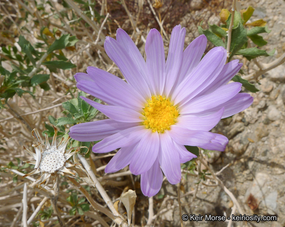
| Fig. 1. Xylorhiza orcuttii, Orcutt's woody-aster, photographs from the Arroyo Salado. Left: Photograph taken by Tom Chester on 23 March 2009. Right: Photograph taken by Fred Melgert in February 2014. Click on the pictures for larger versions.
See Fred Melgert and Carla Hoegen's Anza-Borrego Desert Wildflowers page on Xylorhiza orcuttii for a number of additional pictures. | ||
Table of Contents
Introduction
Photographs of Distinguishing Characteristics from its Sister Species
Geographic Distribution
An at least 20 year old plant
Appendix 1. Discussion of Voucher Locations
Introduction
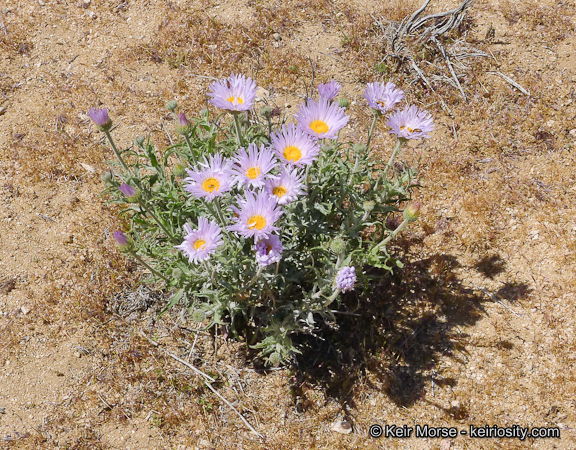
Xylorhiza orcuttii is a delightful species, which is easily spotted by anyone hiking where it lives. It is a large showy plant, with large blooms (typically 5-6 cm = 2-3 inches across) on a decent-size shrub typically 1-4 feet high and as wide or wider. It blooms fairly reliably during most of the winter and spring months, responding to monsoonal rain and to winter rain. It is fairly abundant in the Badland Washes. It is easily identified when in bloom, since we have no other species that looks anything like it. It has fat buds, and its leaves are also often distinctly toothed, allowing it to be identified even when it is not in bloom. Note, however, that it sometimes has leaves that are entire (without teeth), which makes it difficult to be sure of the determination without buds or bloom.
It is a special plant in our area, since it lives only in the ABDSP area or nearby! Such species that have a restricted geographic range are called endemics. Xylorhiza orcuttii is one of only 11 endemic or near-endemic species in ABDSP. The only locations where it lives are shown in Figs. 3 and 4 in the Geographic Distribution section.
Habitat information is given in Fred Melgert and Carla Hoegen's page, along with information about their census of the plants.
Photographs of Distinguishing Characteristics from its Sister Species
Although there is no other species in ABDSP which could be confused with Xylorhiza orcuttii when the plants are in bloom or in bud, there are two other Xylorhiza species in southern California that are similar, each with its own separate geographic distribution. These species are indistinguishable in a photograph of just the flower from the front, but they are quite distinct in other characteristics. Fig. 2 shows photographs of various characteristics of all three species.
| X. cognata | X. orcuttii | X. tortifolia |
|---|---|---|
| 
| 
|

| 
| 
|

| 
| 
|

| 
| 
|
| Fig. 2. Characteristics of three Xylorhiza species, each in the column under the label in the header row. Top row: Flowers from the front. Second row: Phyllaries. Third row: Leaves (see note below). Fourth row: entire plant.
All photographs by Keir Morse except for the bottom photograph of X. orcuttii, and the middle two photographs of X. tortifolia, by Tom Chester. Click on the pictures for larger versions. | ||
These species are distinct enough in their phyllaries that one can just do a picture match. The leaves of X. tortifolia are quite distinct, but the leaves of X. cognata and X. orcuttii do not always separate them. Both X. cognata and X. orcuttii have leaves that are spiny-dentate or entire. Both species can have glabrous leaves, but only X. cognata can have strongly glandular leaves.
The species can also be distinguished as follows:
- X. tortifolia is a perennial herb or subshrub just 2-6(8) dm in height, with a stem generally branched only in its lower half, with long peduncles 8-25 cm;
- The other two species are shrubs up to 1.5 m in height, with stems generally branched throughout, and shorter peduncles of 0-11 cm.
- Of those two species, X. orcuttii has mostly-glabrous stems, peduncles and leaves; X. cognata has short-glandular younger stems and peduncles and leaves, and its leaves range from glabrous to glandular.
Geographic Distribution
The geographic distribution of all three sister species in southern California is shown in Fig. 3.

Fig. 3. The geographic distribution in southern California of three Xylorhiza species. X. tortifolia is a very widespread species, extending throughout the Mojave Desert and into the northern Sonoran Desert east of the Salton Sea. The other two species are confined to a much smaller area, as indicated on the map, and are considered rare species as a result.
The known geographic distribution of Xylorhiza orcuttii, from accurate GPS observations in the field as of 14 February 2016, and from reliably-determined vouchers with localities that are accurate to less than a half mile, is shown in Fig. 4. See also a (older) map showing those two sets of data separately as of 28 January 2016, and appendix discussing the voucher locations. To visualize these GPS points in Google Earth, download an older kml file as of 21 January 2016.

Fig. 4. The entire world-wide geographic distribution of Xylorhiza orcuttii, a species endemic to the area from the Borrego Badlands to the western edge of the Salton Sea, and in the vicinity of the Carrizo Badlands, with one occurrence on the south side of the Coyote Mountains. The map is current as of 14 February 2016. See also expanded map of northern half and map of southern half of the distribution, as well as the Berkeley Clustering Algorithm version of these points, showing how many points are found in different areas.
Fred Melgert and Carla Hoegen are mapping all the Xylorhiza orcuttii in Anza Borrego Desert State Park. See Anza-Borrego Desert Wildflowers: Xylorhiza orcuttii for their latest interactive map, along with descriptions of the plants in each of their surveys. This is a tremendous undertaking by them to map this species, which has already resulted in a treasure trove of information about this rare species!
The rest of this section discusses the distribution of Xylorhiza orcuttii as of 14 February 2016, giving a history of the mapping of this species, and preliminary analysis.
The detailed distribution of Xylorhiza orcuttii is quite interesting; it is concentrated in the upper reaches of the Badland Drainages.
Keir Morse GPS'd every occurrence in Inspiration and Fonts Point Washes on 9 and 13 January 2016, with the survey routes shown as the dotted red lines in those washes in the linked map. The largest concentration was in the 1.4 miles of uppermost Inspiration Wash, just north of Inspiration Point, at elevations of 920 to 1130 feet, with only scattered occurrences lower in the wash. Oddly, there were only two locations in the next drainage east of that wash, a tributary of Fonts Point Wash. The other tributaries of Fonts Point Wash only had Xylorhiza orcuttii in a single short stretch.
Fred Melgert and Carla Hoegen GPS'd every occurrence in a loop containing Deguynos Canyon, on the south of Fish Creek, on 19 January 2016, finding 149 live plants at 115 unique GPS locations. They also found that Xylorhiza orcuttii was concentrated in the uppermost portion of that Canyon, from 800 to 950 feet elevation, as well in the upper part of its adjoining tributary. Their survey route is also shown as the dotted red lines.
Fred and Carla GPS'd a nearby loop on 27 January 2016 to make a very complete map of the Xylorhiza orcuttii in that area of the Carrizo Badlands. On that loop, they found 330 live plants at 307 unique GPS locations. See the map from both the 19 and 27 January 2016 surveys.
Fred and Carla GPS'd every occurrence in a loop on the north side of the Coyote Mountains on 25 January 2016, finding 50 plants that could be reliably identified, plus perhaps another five that didn't have leaves and looked dead.
Fig. 5 gives the histogram of the elevations from vouchers and from our GPS points. The voucher elevations were derived from a human interpolating the contours on the USGS topographic map. Xylorhiza orcuttii appears to be fairly abundant between elevations of sea level to 1200 feet, with the lowest recorded elevation at -50 feet (Duncan Bell's voucher from Tule Wash near the Powerline Road) and the highest at 1580 feet (J. Mark Porter's voucher from two miles up Palo Verde Canyon).

Fig. 5. Histogram of the elevations of Xylorhiza orcuttii locations from vouchers and from our GPS points as of 19 January 2016. The range of elevations is probably very complete, but the detailed shape of this histogram is heavily influenced by the large number of points from Inspiration Wash, Deguynos Canyon, the north side of the Coyote Mountains, and from Rebman's survey of the Freeman Properties just west of the Salton Sea. The true shape of the histogram will become apparent as we accumulate more comprehensive surveys.
An at least 20 year old plant
On 2 April 2016, Fred Melgert and Carla Hoegen noticed that there was a very distinctive Xylorhiza orcuttii plant hanging on the cliff face immediately next to a famous geologic location called "The Anticline". Since this is a very-often photographed location, this plant appears in many photos, including older ones that can be used to give a minimum lifetime of the plant, and to see how it has changed with time.
Fig. 6 shows some of the photographs we have taken, and ones we have found on the web. If you have an older photo of this plant, we would love to show it here!
| 2004, from Greg Vaughn | |

| (Intentionally blank) |
| 6 March 2006, from Sets and Jan | |

| (Intentionally blank) |
| 11 November 2010 from Tom Chester | |

| 
|
| 16 February 2015, from Fred Melgert and Carla Hoegen | |

| (Intentionally blank) |
| 4 February 2016, from Fred Melgert and Carla Hoegen | |
| (Intentionally blank) | 
|
| 30 January 2021, from James Dillane | |

| 
|
| 8 October 2021, from Fred Melgert and Carla Hoegen | |

| 
|
| 9 March 2022, from Fred Melgert and Carla Hoegen | |

| 
|
| 5 December 2022, from Fred Melgert and Carla Hoegen | |

| 
|
| 12 January 2023, from Tom Chester | |

| 
|
| 13 November 2024, from Fred Melgert and Carla Hoegen | |
| (Intentionally blank) | 
|
| Fig. 6. A time series set of photographs of a plant next to The Anticline that was at least 19 years old in 2023, assuming it was in its first year in 2004. Of course, since we've seen it living there for 20 years now, it could well have been 20 years old in 2004. Maybe someday an earlier photograph of this plant will emerge.
The plant was at its best in 2004, the largest in any pix, with many flowers, and appears smallest in 2024. Note the amazing growth in the plant in the 38 days between 5 December 2022 and 12 January 2023. The plant appears to have doubled its number of full-size leaves in that interval. The weather during that period was mostly cool, with high temps in Borrego Springs of 60 to 72 deg, with only three days above 75 deg. Click on the pix for larger versions or the original iNat post (some pix don't have a larger version). The 2004 pix by Greg Vaughn was originally sent to ABDNHA, after they posted a pix by Marcy Yates, and Fred Melgert asked them to solicit earlier photos. | |
Appendix 1. Discussion of Voucher Locations
There are 133 consortium vouchers of Xylorhiza orcuttii as of 20 January 2016. Of those, three are almost surely either misdetermined specimens of X. cognata, or have incorrect voucher locations.
Of the 130 remaining vouchers of X. orcuttii, 72 have vague locations such as Borrego Springs; Colorado Desert, near Salton Sea; and Split Mountain, or flat-out incorrect locations such as Banner Grade and Little Blair Valley, where X. orcuttii does not live. (It doesn't live in Borrego Springs proper, either, with the closest known location 7 air miles east of Christmas Circle in Borrego Springs.) These vouchers cannot be accurately georeferenced if one desires an accuracy of a half mile or less.
Of the 58 vouchers with reasonably-accurate locations, 12 are duplicate vouchers, leaving 46 unique locations, which are plotted in Fig. 4 above.
Trying to georeference the 72 vouchers with vague locations, and including misdetermined vouchers and vouchers with incorrect locations, leads to a geographic distribution map that does not accurately represent the range of X. orcuttii (see also map for the same area as shown in Fig. 4). We have placed comments online at the Consortium on the vouchers that are georeferenced outside the actual range of X. orcuttii.
Voucher data provided by the participants of the Consortium of California Herbaria (ucjeps.berkeley.edu/consortium/) on 19 January 2016.
We thank Jim Roberts for supplying some valuable GPS points to fill in the Coyote Mountain Wilderness Area.
Go to:
Copyright © 2016-2024 by Tom Chester, Fred Melgert, Carla Hoegen, Mike Crouse, Kate Harper, Adrienne Ballwey, James Dillane, and Keir Morse.
Commercial rights reserved. Permission is granted to reproduce any or all of this page for individual or non-profit institutional internal use as long as credit is given to us at this source:
http://tchester.org/bd/species/asteraceae/xylorhiza_orcuttii.html
Comments and feedback: Tom Chester
Updated 14 November 2024