How to Use This Table
The table lists the plant communities along the Angeles Crest Highway, otherwise known as State Route 2 (SR2), from the I-210 at La Cañada to SR138 at Mountain Top Junction in San Bernardino County.
The column Odo is the odometer reading in your car beginning at the turn onto the Highway from Interstate 210 in La Cañada.
MM is the reading on the white mile marker at the edge of the road. Mile markers do not begin with zero at the turnoff, but farther southwest in the city of Santa Monica where State Route 2 begins.
Elev is elevation in feet, read from CalTrans signs, if available; otherwise from the USGS topographic maps.
Feature are turnouts, trailheads and picnic areas where you can stop and observe the plants. Road junctions are also listed because they are easy to find. A note is made whether the parking is on the right or left. Parking on the left requires a turn across traffic, and is generally not recommended. Instead, stop at those locations on the return trip or if beginning from Wrightwood.
Slope is the direction the mountainside faces. For example, if you stopped at Switzer Picnic Area and looked at the mountainside across SR2, you would be facing north looking at chaparral on a south-facing slope. Then, if you walked to the edge of the parking lot and looked down to the bottom of the canyon, you would see the trees that are part of the riparian woodland lining the streambed.
Plant Communities are the assemblages of dominant plants, usually trees, you are likely to see at a given stop. These are covered in much greater detail in the companion pages about Plant Communities of the San Gabriel Mountains. Links to pictures of the different communities and plants therein can be found on the individual plant community pages.
Variations When the plant community changes, the dominant trees or shrubs are listed. When a certain tree is no longer seen, it is marked with a minus sign like "-Coulter pine". Conversely, when a new tree or shrub begins to appear, it is marked with a plus sign like "+Jeffrey pine". Sometimes special features like wildflowers are listed. Although there appears to be a lot of montane forest, it is far from uniform and some of its many variations are noted in this column.
Look at the profile below for an overview of how the plant communities change with elevation and slope aspect (whether they face toward the coast, sunny, or toward the desert, shady).
| Elevation and Plant Communities Profile on ACH | ||||||
|---|---|---|---|---|---|---|
| Odo | MM | Elev | Feature | Slope | Plant Community | Variations |
| 0.0 | 24.54 | 1400 | I-210 | all | urban | |
| 2.5 | 27.00 | 2020 | ANF boundary | all | foothill woodland | walnut |
| 2.7 | 27.20 | 2080 | Turnout with view of Los Angeles Basin, on right | all | coastal sage scrub | buckwheat, white sage |
| 3.1 | 27.40 | 2400 | Angeles Crest Station, on left | all | coastal sage scrub | +mountain mahogany, deerweed |
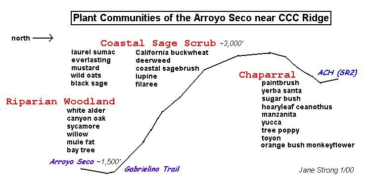
| Cross Section of Plant Communities of the Arroyo Seco near CCC Ridge | ||||||
| 6.1 | 30.20 | 2920 | CCC Ridge trailhead, on right | south | coastal sage scrub | |
| north | chaparral | manzanita, ceanothus, yucca | ||||
| 8.2 | 32.60 | 3640 | Clear Creek Vista, on left | all | chaparral | +scrub oak |
| 9.2 | 33.80 | 3648 | Jct: Angeles Forest Highway | all | chaparral | |
| 9.6 | 34.14 | 3520 | Switzer Picnic Area, on right | south | chaparral | |
| bottom | riparian | white alder, canyon oak, bigleaf maple, California bay tree | ||||
| 9.9 | 34.50 | 3480 | Colby Canyon trailhead, on left | south | chapparal | |
| Cross Section of Plant Communities of the Upper Arroyo Seco | ||||||
| 13.0 | 37.60 | 4400 | Turnout; view of upper Arroyo Seco, on right | north | low elev montane forest | bigcone spruce, canyon oak |
| 13.7 | 38.38 | 4666 | Red Box; Jct: Mt. Wilson Road, on right | north | low elev montane forest | |
| 15.8 | 40.41 | 4600 | Turnout; view of West Fork and Mt. Wilson, on right | north | low elev montane forest | |
| 17.9 | 42.60 | 4800 | Jct: Barley Flats Rd, Upper Big Tujunga Rd, on left | south | chaparral | |
| 18.6 | 43.30 | 4880 | Shortcut Saddle, on right | both | chaparral | |
| 21.3 | 46.00 | 5111 | Turnout; view of Big 4 peaks, SG Wilderness | east | mid elev montane forest | Coulter pine, canyon oak |
| Plant Communities of the Charlton Flat-Chilao Recreation Area | ||||||
| 22.8 | 47.50 | 5393 | Charlton Flats Picnic Area, on left | north | mid elev montane forest | +Jeffrey pine, incense cedar |
| 25.8 | 50.50 | 5280 | Devils Canyon trailhead on right, parking on left | east | mid elev montane forest | |
| 25.9 | 50.60 | 5300 | Chilao Visitor Center, on left | north | mid elev montane forest | |
| 26.3 | 50.93 | 5303 | Newcomb's Inn, on left | north | mid elev montane forest | |
| 28.1 | 52.80 | 5911 | Three Points trailhead; Jct: Santa Clara Divide Road, on left | south | mid elev montane forest | -Coulter pine |
| 29.5 | 54.02 | 6200 | PCT Xing, parking on right | south | mid elev montane forest | dry form: mostly Jeffrey pine |
| 31.2 | 56.97 | 6720 | PCT Xing, parking on left | south | mid elev montane forest | dry form: mostly Jeffrey pine |
| 32.3 | 57.10 | 7018 | Cloudburst Summit | north | high country montane forest | Jeffrey pine, sugar pine, white fir, canyon oak, incense cedar |
| 32.6 | 57.50 | 6940 | Mt. Waterman Ski Area | north | high country montane forest | |
| 33.0 | 57.70 | 6920 | Turnout; Buckhorn Peak trailhead, on left | north | high country montane forest | |
| 33.3 | 58.00 | 6791 | Buckhorn-Mt. Waterman Trailhead on right, parking on left | north | high country montane forest | |
| Cross Section of the Plant Communities of Buckhorn Flat | ||||||
| 33.4 | 58.25 | 6740 | Buckhorn Campground entrance, on left | north | high country montane forest | |
| 34.5 | 60.10 | 6800 | Snowcrest Ski Area, formerly Kratka Ridge, on right | north | high country montane forest | |
| 35.9 | 60.50 | 6840 | Vista Picnic Area on right | north | high country montane forest | |
| 36.9 | 61.60 | 6600 | Eagle's Roost Picnic Area, PCT parking, on right | north | high country montane forest | planted ash and black locust |
| 37.7 | 62.40 | 6740 | Mt. Williamson trailhead, on left | north | high country montane forest | dry form, mostly Jeffrey pine |
| 38.7 | 63.50 | 6800 | Jarvi Memorial Vista, on right | south | high country montane forest | many labeled plants |
| Cross Section of Plant Communities between Islip and Dawson Saddles | ||||||
| 39.2 | 64.10 | 6660 | Islip Saddle, PCT parking lot on left, closed SR 39 on right | saddle | high country montane forest | |
| 40.6 | 65.50 | 6980 | Mt. Islip, Little Jimmy Spring trailhead, on right | north | high country montane forest | |
| 42.7 | 67.60 | 7561 | Best snow-melt gully for wildflowers; desert view | north | high country montane forest | |
| 44.5 | 69.60 | 7903 | Dawson Saddle; parking for Throop Peak trailhead; view of Mojave Desert and Pinyon Ridge, on left | north | high country montane forest | +lodgepole pine, limber pine on highest peaks |
| 45.4 | 70.60 | 7720 | Dorr Canyon; desert views, geology, on right | north | high country montane forest | |
| Cross Section of Plant Communities on Manzanita Trail | ||||||
| 49.8 | 74.80 | 6565 | Vincent Gap, PCT parking on right | saddle | high country montane forest | + bigleaf maple, willows, berries |
| 51.3 | 77.30 | 7200 | Grassy Hollow Visitor Center, on left | south | high country montane forest | dry form: mostly Jeffrey pine |
| Cross Section of the Plant Community of Lightning Ridge | ||||||
| 52.2 | 78.20 | 7360 | Lightning Ridge and PCT parking on left; Blue Ridge Road, Inspiration Point Parking on right | north | high country montane forest | +black oak, wildflowers |
| 53.9 | 79.90 | 6862 | Big Pines | south | high country montane forest | +black oak, willows |
| 54.8 | 80.80 | 6560 | Mountain High East | east | high country montane forest | |
| 56.3 | 82.30 | 5931 | Los Angeles/San Bernardino County Line; Wrightwood | east | high country montane forest | |
| bottom | riparian woodland | excellent fall color | ||||
| 58.2 | SB0.00 | 5800 | Lone Pine Canyon Rd | east | suburban | |
| 60.5 | SB2.30 | 5200 | Desert Front Rd | north | pinyon-juniper woodland | |
| 61.0 | SB5.00 | 5000 | ANF boundary | north | Joshua tree woodland | spring wildflowers |
Go to:
Copyright © 2000 by Jane Strong and Tom Chester.
Permission is freely granted to reproduce any or all of this page as long as credit is given to us at this source:
http://tchester.org/sgm/conditions/plants/guides/ach_veg.html
Comments and feedback: Jane Strong | Tom Chester
Updated 2 May 2000