Participants: Craig Cheetham and Tom Chester
Date: 16 September 1999 and 8 August 1983 (both written up 17-18 September 1999)See Links for hike #93 for the latest information about this hike, including a possible road closure, making this trip even longer and tougher.
Description: After being seriously affected by altitude sickness in 1983 on my first hike to 10,000', I swore off hiking above 9,000' or so and never thought I would return to such high altitudes. In 1983, I not only got a severe headache by the time I got to Baldy, but on the way back between Baldy and Dawson I had the only "out of body" experience I've ever had. As I plodded along, it seemed to me that my mind was many feet above the poor miserable soul wishing desperately that he were at lower elevation, yet having to go to higher elevation (to 9,500') twice before finally descending to air with more oxygen content.
I'm one of the 15-17% of people who get acute mountain sickness ("headache, fatigue, shortness of breath, sometimes nausea and vomiting") above 8,000', which is independent of one's physical condition (Going Higher, Charles S. Houston, p. 126). If I arrive at 5,000-6,000' by car, when I get out I can hardly walk. However, one night of acclimatization helps me immensely at those altitudes. When I arrive at the Grand Canyon at 7,200', by car from Southern California, I can barely make it across the parking lot without huffing and puffing and moving quite slowly. I've always been certain that any spectator, upon seeing me struggle to walk normally on level ground, would howl with laughter from disbelief if they were informed that I would hike 16 miles and 5,000' altitude change to the bottom and back the next day with no problems.
I finally realized that I might be able to do Baldy again if I spent a night at altitude beforehand. Hence when Craig suggested this hike again, I stayed at 5,931' Wrightwood the previous night. And it worked! I had no problems with altitude sickness at all, which made this a delightful trip. Interestingly, the total time was not much changed by my acclimatization, 10:13 this time vs. 10:19 earlier.
This is a beautiful hike in stunning terrain, with views ranging from the distant Tehachapis and the Mojave Desert, to a stunning close-up view of Cajon Pass and Lytle Creek and the neighboring titans of San Gorgonio and San Jacinto, as well as most of the San Gabriel Mountains at once.
The trail is not for the faint-of-heart. It's called the Devil's Backbone, because in places you will surely meet the Devil (figuratively) by falling to your death (literally) if you wander more than a yard or two from the trail. In other places, the footing is quite insecure, and the hike is more like controlled falling in loose scree, or painstaking foot placement in steep trail sections. On the other hand, you don't have to worry about meeting any mountain bikes on this trail!
Fortunately, only a small percentage of the trail meets either of those two conditions, and most of the trail is normal high-country trail that can be hiked without worry.
This trail was number 93 in the 1990 and previous editions of Trails of the Angeles, but was omitted in the 1998 edition. Robinson says this trip is 10 miles roundtrip and 3,000' of elevation gain in the 1990 and earlier editions, but the actual elevation gain is at least ~4,300' if one does not make the side trips to the peaks of Pine and Dawson, and at least ~4,550' if one does. Because of that discrepancy, I will be quite explicit about the elevation changes along the trail in the text below. The elevations quoted in the text below will be actual elevations read from the topo map, whereas the elevations in the trip log are those from my altimeter which is accurate to only 100-200'. I recorded 11.0 miles on my pedometer for the trip described below which went to those peaks.
The view from the beginning is stunning, and it just keeps getting better, except if the atmosphere makes the visibility worse. At the beginning, the view down Prairie Fork of the East Fork of the San Gabriel River leads directly to massive Mt. Baden-Powell, with a distant view of the Mt. Wilson and San Gabriel Peak area to its left.
From ~8,310' at the trailhead on the south slope of Wright Mountain, the trail descends ~130' to the ~8180' saddle between Wright and Pine Mountains. The way up to Pine Mountain is not straight up - the trail rises ~375' to 8,555', descends ~95' to a double saddle, and then ascends ~1,020' to a shoulder around Pine Mountain at ~9,480'. The portion past the 8,555' intermediate peak is the area where it is clear that if you fell off the side, you wouldn't stop for a very long time. It's followed by a portion that is relatively easy to go up, but descending is difficult due to the steepness and poor footing. After those two sections, the rest of the trail to Pine is a cake walk, at least in terms of placing one's feet along the trail.
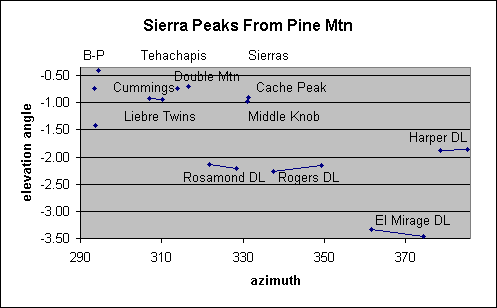
At Pine Mountain, Baldy and West Baldy dominate the horizon, and many other San Gabriel Mountain peaks begin to emerge from behind Baden-Powell. The panorama is truly stunning, and one can study the Cajon Pass closely, watching the vehicles on I-15. The view of the desert includes the usual dry lakes (from west to east: Rosamond, Rogers, El Mirage and Harper), with the Tehachapi Mountains to the left of Rosamond Dry Lake, and the Southern Sierra peaks of Middle Knob and Cache Peak in the Piute Mountains visible between Rosamond and Rogers Dry Lakes. See calculated elevation angles and azimuthal angles to features in the north and compare it to a poor-resolution labeled photograph. The peaks on the horizon are better seen with the human eye, which has much better resolution than this digital camera photograph, which was enhanced to bring out those peaks and dry lakes.
The trail descends ~330' to the saddle between Pine and Dawson at 9,151', where the low thorny ceanothus (mountain whitethorn) has closed over the trail in a few spots. Ascending ~340' achieves a shoulder close to Dawson Peak at ~9,500'.
Although you are only ~560' below Baldy, the trail descends ~720' to the saddle between Dawson and Baldy at ~8,780' before the final ~1,280' to Baldy at 10,064'.
On the way up Baldy, as well as all other uphills at high altitude, my normal pace is to take 30-50 steps, then rest for 15-50 seconds. On one of those rest stops I realized that this situation was perfect to finally collect some data to try to understand why my pedometer could possibly be as accurate as it has been observed to be. I counted my steps, and recorded how many steps were recorded by my new (auxiliary) pedometer. The answer was as I conjectured several years ago: on the uphill, the new pedometer recorded only 67% of my steps (307 out of 460). On the downhill, it recorded 95% of my steps (380 out of 400).
Baldy has a broad top, so to truly appreciate the view in all directions you need to walk a bit away from the peak in each direction. See Peaks From Baldy (elevation angles and azimuth angles to some of the visible peaks). For us, the air had gotten much hazier by the time we arrived at Baldy, and the view to the south was essentially non-existent except for Elsinore and Santiago Peaks in the Santa Anas. We were just able to make out the faintest trace of the Palomar Mountain Ridgeline.
On the way back, if the day is cloudy, note the "patches of sunlight" along the trail up Dawson. However, those "patches of sunlight" are fixed on the ground, and due to light-colored intrusive granite rocks amidst the surrounding dark gray rocks. (I failed to notice this until Craig pointed it out, and was only convinced when the patches didn't move as we descended Baldy!)
The trail to the peak of Dawson (9,575') is clearly seen on the way back about 100' below the Peak. If you take that trail to Dawson, you can either descend that trail back to the trail junction, or meander along the ridge to the west-northwest until you meet the trail again. When we did the latter option, the trail looked different enough to both Craig and me that we thought we were on a different ridge trail until we met the Fish Fork Trail at the same point as on the way up.
On the way to Pine Mountain, although we didn't see a trail junction for the trail leading to the peak of Pine Mountain (9,648'), we ended up there anyway, and didn't see any junction on the other side either. Must have been the altitude!
Because the weather was so cool, I consumed only 2.1 liters of the 3.3 liters of water I carried, and had no discernable water deficit at the end of the trail at all.
Trail condition: The trail is clear and passable in all places except just north of the Pine - Dawson Saddle, where the low thorny ceanothus (mountain whitethorn) has almost closed over the trail in a few spots.
Plants in bloom: This is clearly Rabbitbrush heaven. The entire south slope of Pine Mountain is covered with rabbitbrush in stunning bloom. In addition, the pinkish-red of buckwheat and another variety with small red flowers with yellow insides fill the slope in between the rabbitbrush.
Other plants in bloom, in much smaller numbers, include a short penstemon, a low yellow fuzzy flower on a half-inch stem, and nude buckwheat. Red berries are evident on a few plants. The "yellow-green bladder pod" plant is finished.Weather: Absolutely delightful everywhere except on Baldy. Instead of highs in the high 80's and low 90's recently in the high country, this unusually cool day featured temperatures of 64° at the start at 9 a.m., 67° on Pine at 10:30 a.m., 62° at Dawson - Baldy Saddle at noon and 3:30 p.m., and a chilly 57° at Baldy at 2 p.m.
Bugs: There were zero bugs of any sorts during the entire trip. It was again absolutely delightful to not be bugged!
Number of ticks: Zero.
Number of rattlesnakes: Zero.
Other pests: None.
Explanation of columns for all trip logs
Trip log from 9/17/99:
# Mileage Time arrived Time left Altitude Comments 0 0.00 8:44 8250 Trailhead below Wright Mountain 1 0.20 8:51 8150 Started other pedometer here 2 1.75 10:29 10:40 9500 Pine Mountain 3 2.50 11:02 9050 Pine - Dawson Saddle 4 2.55 11:07 9050 Jct. Fish Fork Creek Trail. Sign: Mt. San Antonio (arrow left), Fish Fork Creek (arrow right) 5 3.02 11:27 9300 Rounding Dawson Peak just below peak 6 4.12 11:53 12:10 8700 Dawson - Baldy Saddle 7 4.92 1:10 9650 Sign: "North Backbone Trail" 8 5.05 1:21 9750 Last major tree before summit 9 5.17 1:30 9900 Sign: "North Backbone Trail to Blue Ridge" 10 5.20 1:32 9950 Baldy 11 5.45 2:17 9900 Left Baldy 12 5.60 2:21 9800 =8 13 5.75 2:30 9620 =7 14 6.82 3:11 3:32 8700 =6 15 7.50 4:15 9350 Jct Trail to Dawson Peak we missed earlier due to sharp angle. Took it by going right. 16 7.58 4:25 4:28 9450 Dawson Peak 17 7.72 4:31 9400 Back on main trail, slightly north of junction in #15 18 8.25 4:46 9100 =4 19 8.40 4:51 9050 =3 20 8.80 5:27 5:42 9500 =2 21 10.25 6:27 8400 The second of two unnamed saddles 22 10.45 6:37 8500 Local high point on trail 23 10.82 6:48 8150 Wright - Pine Saddle 24 11.00 6:57 8300 Cars Trip log from 8/8/83, my eighth hike with Craig in the SGM:
# Mileage Time arrived Time left Altitude Comments 0 0.00 9:45 Car 1 1.50 11:25 11:55 Shoulder of Pine Mtn.; Craig's time 2 12:10 Snow on Trail 3 2.25 12:40 Dawson / Pine saddle 4 1:40 Baldy / Dawson saddle; Craig's time 5 4.65 3:00 3:35 Baldy 6 5.90 4:45 5:00 Baldy / Dawson saddle 7 7.10 6:30 Dawson / Pine saddle 8 6:56 Top of Pine Mtn; Craig's time 9 9.30 8:04 Car
Go to:
Copyright © 1999-2001 by Tom Chester.
Permission is freely granted to reproduce any or all of this page as long as credit is given to me at this source:
http://tchester.org/sgm/hikes/tc/93.html
Comments and feedback: Tom Chester
Updated 20 September 1999 (one update added 6/10/00, 9/1/00, and 1/15/01).