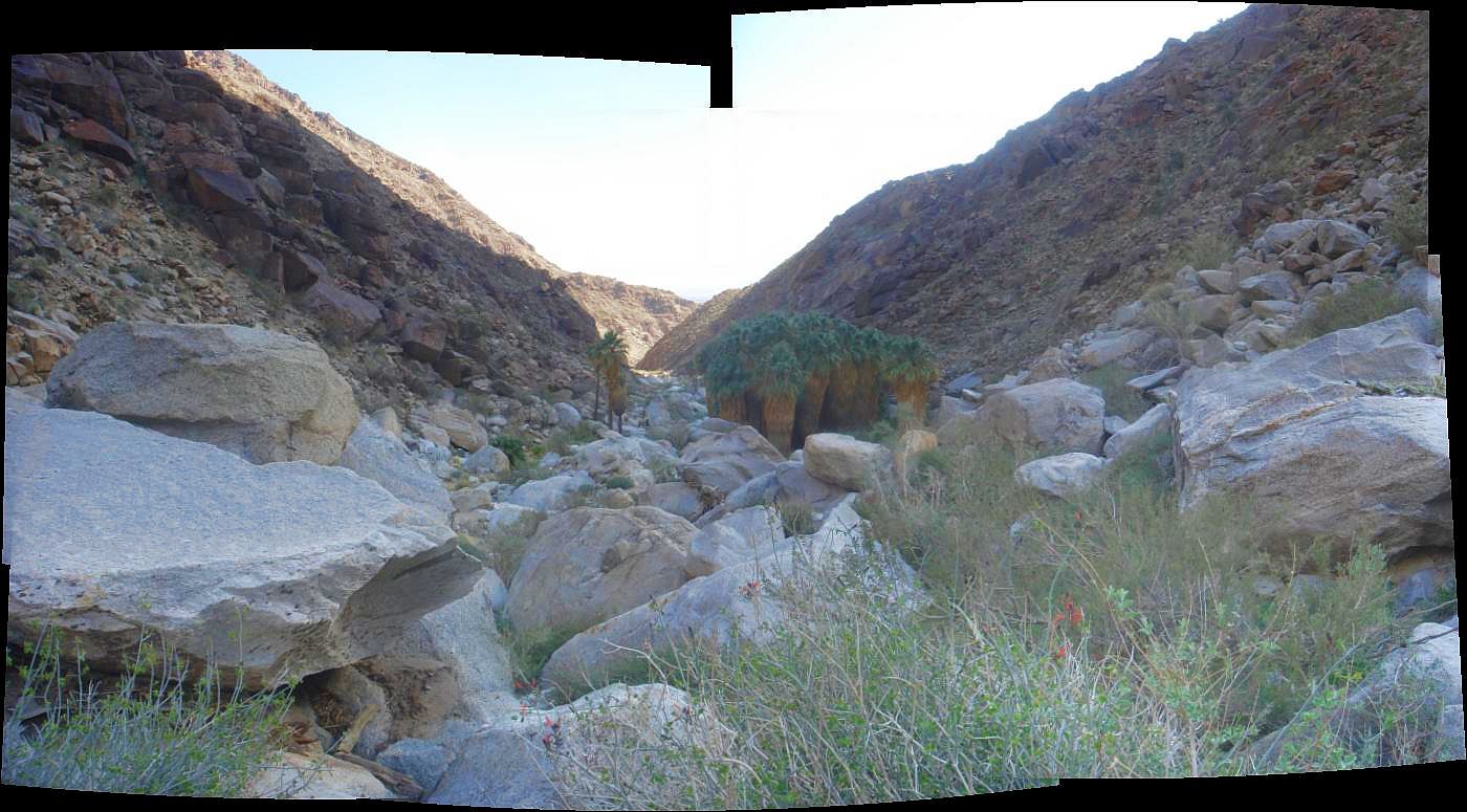
Panorama of five pictures taken on 31 January 2010 from just above the first palm grove looking down to the mouth of the Canyon (larger version). These palm trees are the remnants of a much larger grove prior to the 2004 flash flood that took out a large number of the palm trees here. See picture of ~five year old palm trees that are regenerating the former grove.
Introduction and Explanation of Plant Trail Guides
Introduction
Detailed Changes To The Trail After The 9/04 Flash Flood
Highlights of This Trail
Fieldwork Dates and Summary of List Changes With Time
Botanical Trip Reports
The Plant Guide
Comments On Specific Species
Introduction
This trail is the most popular one in the Anza-Borrego Desert State Park, for several good reasons. Physically, the trail is easily reached from the Visitor Center, and the trailhead is in a campground. Botanically, the trail passes through many diverse environments, offering a sampler of much of the flora of the area. The trail ends at the most treasured destination in a desert - a shady palm grove, with year-round water and a small waterfall.
However, this poor trail has been hit by flash floods two years in a row! The first one (actually apparently several of them closely spaced in time), reportedly with a 10 foot high wall of water, occurred in August 2003, destroyed the bridge on the trail and caused three other short sections to be re-routed. That flood only damaged a small number of palm trees.
The second one, on 10 September 2004, has been described as a 100 year flood, and we believe it. A 5-10 foot tall, 100 feet wide wall of water was observed at the campground, coming out of the mouth of Borrego Palm Canyon. That flood took out a large number of palm trees (~80% of the individuals in the First Grove), leaving them scattered along the lower portions of the trail, and sometimes in stacks of three palm trees angled on top of each other. Many of the trunks were broken by the force of the water, and some palm tree trunks even ended up below large boulders!

Panorama of three pictures taken on 31 January 2010, four years after the September 2004 flash flood. Also note the high water mark line of logs at left in the larger version of this photo.
This last flood wreaked havoc with two portions of this plant guide. Many of the specific plants recorded in the plant trail guide in those portions are no longer present; they have been uprooted and washed down stream. In fact, the former trail no longer exists in one area. Portions of that area have now been converted to wash, and will not have those species growing there again for some time, if ever.
A detailed discussion of the changes is given below.
The rangers and staff at Anza-Borrego Desert State Park have done a lot of work in restoring and rerouting the main trail. Most of the re-routing takes advantage of a neighboring wash, so new trail construction was kept to a minimum. See the map made from GPS recording of the old and new trail as of spring 2005. The red portion is the major reroute. There is also a minor reroute in the wash, which is too small-scale to show up on the map. [As of 2010, the new trail was extended yet farther north, and now doesn't join the old trail until the creek crossing.]
In some places, the staff had to chain-saw up numerous palm trees to open a path. In at least one place, there was a lot of deposition of other plant material as well, which had to be removed. Your feet can stay dry during the multiple crossings of the main stream, despite significant water flow, due to well-placed logs and rocks. All of us hikers are deeply grateful for all the work done to allow us such easy passage.
The destruction, while widespread, is by no means total. There are still ~20 palm trees visible in the first grove, which still is a beautiful destination. The entire alternate trail is intact and unchanged. Over two-thirds of the main trail is intact and unchanged except for scattered palm tree trunks. The rerouted main trail is easily traversed by anyone who can follow a route tagged by marking tape. [As of 2010, the new trail now just looks like the trail, and is lined with rocks in many places to make its path clear.]
Because there may yet be changes to the alignment of the trail in the future, we have left intact the guide to the trail as it was prior to 2004, including the numbering of the first occurrences of taxa found in the bypassed section. It is even quite possible that the official route will revert to the entire old trail, since it would take only a small amount of trail construction to completely restore that route.
We have added the new routes, as of 20 January 2005 and 31 January 2010, to the guide, and indicate clearly which portions of the guide are no longer on the new route. However, the guide remains primarily a description of the old route.
For species whose first occurrence was only in the superceded sections, we have begun noting their first occurrence on the new route. These occurrences are not numbered as new taxa, since each one has already been counted in the guide. However, a number of the taxa were found only in or adjacent to the washes themselves, and it may be a few years before those taxa re-appear.
In 2010, we finally realized how unique conditions were in 2004 and 2005. A lot of the species seen in those years, especially off-trail in the washes, were higher-elevation species whose seeds had been washed down in the flash floods, and that were not normally present in this area. As a result, we have moved all those species to a separate list at the end of the guide. A few of these species that had been encountered on trail are still listed in the guide with a note that it is not likely that you will see them.
This guide includes the highlights from the 1999 brochure that is sometimes available at the trailhead. The brochure is keyed to 15 numbered posts along the trail. (Note that there was an earlier 1990 brochure keyed to 18 numbered posts, some of which were at different locations and numbered differently.)
Most of those numbered posts were taken out by the 2004 flood. In many cases, a careful observer can find the stump of the post remaining, and some of the locations have marking tape with the old post number on it.
Even more confusing, in 2006 new numbered posts were added to many places, but some of them differ by one number from the post in that location previously. There is a new guide keyed to those posts available at the trailhead.
This trail guide will be, therefore, a bit challenging to follow exactly.
Historical note:
On 20 January 2005, the visitor center staff is advising people to take the alternate trail up, not the main trail. There is even a sawhorse at the trailhead which has a sign on it saying Trail washed out; use alternate trail. This recommendation is for those people who have difficulty following anything other than a well-defined trail.We recommend that you ignore that sign and take the trail anyway unless you are not comfortable following a route that is not obvious at times, and thus requires some paying attention to divine the route. There is no actual prohibition against taking the main trail, and it looked like nearly everyone who took the alternate trail up was taking the main trail down. There is no similar sign at the top of the main trail.
That sign was removed sometime in March 2005.
Detailed Changes To The Trail After The 9/04 Flash Flood
This report is from detailed observations made on 1/24/05.
The trail and surroundings are exactly the same from mile 0.00 to mile 0.10. The trail itself is roughly, but not always exactly, the same route from mile 0.10 to mile 0.58, but the surroundings have changed dramatically in portions of that segment.
The wash itself from mile 0.10 to mile 0.13 is very different. There used to be two separate channels, with a non-wash, higher ground in-between at mile ~0.11. That higher ground is now completely gone, as are the two taxa in the guide for that location (California fagonia, Fagonia laevis, and Anderson's desert-thorn, Lycium andersonii), along with signpost 3. Thus now there is only a single, wider wash.
Second, the main wash is now closer to the trail at mile 0.14 and perhaps beyond. The water has taken a bend to its right, and chewed into the right bank of the drainage.
This has taken out the desert-willow, Chilopsis linearis ssp. arcuata, next to the catclaw, Acacia greggii, with desert mistletoe, Phoradendron californicum, as well as signpost 4. There is no longer a need for signpost 4, since its subject was the home that the desert willows made for birds.
The trail from mile 0.14 to 0.35 is shifted left of the old trail, and the stream-crossing is at a slightly-different location. The surroundings between mile 0.27 and mile 0.34 have been changed tremendously by the 9/04 flood, and many of the plant taxa were taken out by the flood. Presumably, most of those will eventually return.
Soon after the crossing of the main wash on the changed trail, at mile 0.32, there is now a new channel for the stream that must also be crossed. We had not even a mention in the guide of crossing a dry wash here before, so this is a new feature.
After that point, at mile 0.35, the trail and its environment are mostly unchanged until mile 0.46, where signpost 8 used to be. Ironically, signpost 8 said Rolling rocks. Flash floods carried these boulders here. Interestingly, the boulders are still there, but the signpost isn't! In addition, there are now palm tree trunks stacked three deep on top of boulders here.
Just beyond mile 0.46, there used to be several desert willows on the left of the trail. All are now gone except one, which has been seriously smushed. There is no sign of the cattle saltbush, Atriplex polycarpa, but unfortunately the fountain grass, Pennisetum setaceum, survived the flood.
Signpost 9 survived the flood, but the Vasey's sage, Salvia vaseyi, just beyond it did not. Even though the ground is still there, looking very similar to the way it did before, the 3-4 shrubs of this species at that location are completely gone.
At mile 0.58, the old trail is now bypassed by going up the dry wash to the right. See the map made from GPS recording of the old and new trail. The red portion is the major reroute.
However, on 1/24/05, the bypassed old trail is in surprisingly-good shape. There is only one tricky section, which may be the reason they bypassed the trail. Also, perhaps they simply thought it was a good idea to move the trail away from the main wash before it got damaged again.
The bypassed old main trail is mostly intact from mile 0.58 to mile 0.87; even signpost 10 is still present, looking untouched. The stream side of the trail is gone at mile 0.69, but the trail is easily negotiated with any danger of dropping off the side.
The major change is at mile 0.75. Formerly, the trail crossed a dry drainage. That drainage has now become the main channel, full of water seasonally! This makes the next several hundredths of a mile interesting. Once you pick your way across the water twice, you then end up on the intact old trail, with even signpost 11 undamaged.
It will be interesting to see if the now-missing species return to their former locations.
Highlights of This Trail
Number of Unique Taxa On This Trail
The following histogram gives the number of trails in our database that contain each taxon listed in the main trail guide, which does not include the higher-elevation annuals that are only seen here when washed down by infrequent flooding. We had 191 of our trails and floras in our database when this histogram was made; 53 of those trails and floras, including this one, are in Anza-Borrego State Park. A number of "1" means the taxon has only been found only on this list, among all the trails in our database.
| Number of Trails Containing A Taxon | Number Of Taxa On This Trail | % of Taxa On This Trail |
|---|---|---|
| 1 | 2 | 1% |
| 2 | 6 | 3% |
| 3 | 2 | 1% |
| 4 | 3 | 2% |
| 5 | 7 | 4% |
| 1-5 | 20 | 11% |
| 6-10 | 25 | 14% |
| 11-15 | 26 | 15% |
| 16-20 | 22 | 12% |
| 21-25 | 21 | 12% |
| 26-30 | 14 | 8% |
| 31-35 | 9 | 5% |
| 36-40 | 8 | 4% |
| 41-45 | 5 | 3% |
| 46-50 | 12 | 7% |
| 51-55 | 10 | 6% |
| 56-60 | 2 | 1% |
| >60 | 5 | 3% |
| Total Taxa | 179 | 100% |
We found 3 additional taxa not in the above table, since they have not been fully identified yet. The unidentified ones are marked with ?, sp or ssp in the id? column in the guide, and have no entries in the #all column.
The taxa that are unique to this trail, or found on only one other trail or flora that we have done, out of all 191 plant trail guides throughout southern California, as of 7 February 2010, are:
| # trails | Scientific Name | Common Name |
|---|---|---|
| 1 | Astragalus nuttallianus var. cedrosensis | Cedros milk-vetch |
| 1 | Poa bigelovii | Bigelow's blue grass |
| 2 | Astragalus palmeri | Palmer's milk-vetch |
| 2 | Chamaesyce arizonica | Arizona spurge |
| 2 | Chorizanthe fimbriata var. laciniata | lace-fringed spineflower |
| 2 | Cryptantha holoptera | winged cryptantha |
| 2 | Filago depressa | dwarf filago |
| 2 | Vulpia octoflora var. hirtella | hairy six-weeks fescue |
This table does not include species seen only off-trail.
Fieldwork Dates and Summary of List Changes With Time
The following table gives the dates the trail was walked and taxa recorded. After each visit, the table gives the total number of taxa on the list and the breakdown of the taxa without positive identification. See Explanation of Plant Trail Guides to understand the symbols below.
| Visit Date | Visit # | # taxa | # "?" | # "sp" | # "~" | # "ssp" |
|---|---|---|---|---|---|---|
| 3/22/2003 | 1 | 58 | 3 | 7 | 2 | 0 |
| 11/4/2003 | 2 | 79 | 13 | 9 | 2 | 2 |
| 11/8/2003 | 3 | 92 | 23 | 9 | 4 | 1 |
| 2/17/2004 | 4 | 106 | 10 | 14 | 13 | 1 |
| 3/27/2004 | 5 | 130 | 6 | 5 | 15 | 1 |
| 1/20/2005 | 6 | 140 | 3 | 4 | 13 | 0 |
| 1/24/2005 | 7 | 145 | 4 | 4 | 16 | 0 |
| 2/25/2005 | 8 | 155 | 6 | 6 | 11 | 0 |
| 3/1/2005 | 9 | 160 | 5 | 6 | 13 | 0 |
| 3/6/2005 | 10 | 165 | 3 | 4 | 8 | 1 |
| 3/14/2005 | 11 | |||||
| 3/21/2005 | 12 | 174 | 11 | 7 | 9 | 3 |
| 11/23/2005 | 13 | |||||
| 11/27/2005 | 14 | 181 | 6 | 9 | 10 | 3 |
| 2/2/2007 | 15 | 181 | 6 | 9 | 10 | 3 |
| 1/28/2010 | 16 | 182 | 2 | 4 | 8 | 0 |
The 3/22/03 field work was an incomplete list of some of the taxa identified on a fast-paced walk. The 11/4/03 field work was only to mile 1.30. The first time the entire loop trail was covered was 11/8/03.
We did not tally the changes made on 3/14/05 separately; they were few in number since that trip was primarily to voucher some of the taxa not previously recorded for this area.
The number of qualified ids went up dramatically on 3/21/05 primarily due to a large number of new off-trail taxa. On 3/21/05, there were a total of 18 taxa found only off-trail.
The fieldwork on 11/23/05 was only to mile 0.51, and its additions were not separately recorded from those of 11/27/05.
The guide was significantly revised after the 1/28/10 fieldwork. The higher-elevation annuals that are only seen here when washed down by infrequent flooding were moved to a separate section at the end of the guide. Any species with uncertain determinations among them were removed from the list, since we may have to wait until the next 100 year flood to see them. Hence the number of species with uncertain determinations dropped dramatically, but not because more species were identified.
We thank Kay Madore for help with the 2/25/05 and 3/1/05 fieldwork, Kate Shapiro for the addition of the Crossosoma bigelovii to the guide, and Mike Crouse for help with the 1/28/10 fieldwork.
Botanical Trip Reports
17 February 2004
27 March 2004
20 January 2005
24 January 2005
25 February 2005
The Plant Guide
This is a working list, about which we make no guarantees at all until we officially release it. Use at your own risk!
See also Flora of Borrego Palm Canyon.
Version for printing, without lines and other text on this page: html (12 pages) or pdf Clickbook booklet (3 double-sided page). (See printing instructions for an explanation of these options)
| mile | s | # | id | Common Name | Latin Name | #here | #all |
|---|---|---|---|---|---|---|---|
| 0.00 | Begin trail near northwest end of parking lot; elevation ~835 feet (250 m). | ||||||
| 0.00 | l | (Desert pupfish pond, California fan palm, Washingtonia filifera; American tule, Scirpus americanus) | |||||
| 0.00 | r | (honey mesquite, Prosopis glandulosa var. torreyana) | |||||
| 0.00 | l | 1 | desert lavender | Hyptis emoryi | 99 / 9 | 47 | |
| 0.00 | b | 2 | California suncup | Camissonia californica | 99 / 9 | 63 | |
| 0.00 | b | 3 | *Mediterranean schismus | Schismus barbatus | 99 / 9 | 52 | |
| 0.00 | l | 4 | desert dandelion | Malacothrix glabrata | 50 / 7 | 18 | |
| 0.00 | l | 5 | California filago | Filago californica | 99 / 9 | 33 | |
| 0.00 | l | 6 | *redstem filaree | Erodium cicutarium | 99 / 9 | 84 | |
| 0.00 | l | 7 | pale sun-cup | Camissonia pallida ssp. pallida | 50 / 9 | 11 | |
| 0.00 | l | (wire-lettuce, Stephanomeria pauciflora var. pauciflora) | |||||
| 0.00 | l | 8 | brittlebush | Encelia farinosa | 99 / 9 | 55 | |
| 0.00 | b | 9 | cheesebush | Hymenoclea salsola var. salsola | 99 / 9 | 47 | |
| 0.00 | b | 10 | common phacelia | Phacelia distans+ | 99 / 9 | 39 | |
| 0.00 | l | 11 | alkali western tansy-mustard | Descurainia pinnata ssp. halictorum | 99 / 9 | 8 | |
| 0.00 | b | 12 | *London rocket | Sisymbrium irio | 99 / 9 | 24 | |
| 0.00 | r | 13 | desert thornapple | Datura discolor+ | 30 / 9 | 9 | |
| 0.00 | l | 14 | creosote bush | Larrea tridentata | 99 / 9 | 56 | |
| 0.00 | l | (Gander's cholla, Opuntia ganderi) | |||||
| 0.00 | l | Drinking fountain, shaded display board, trail brochures. | |||||
| 0.00 | r | Women's flush toilet | |||||
| 0.00 | r | 15 | *red brome | Bromus madritensis ssp. rubens | 50 / 9 | 86 | |
| 0.00 | r | 16 | threadstem | Pterostegia drymarioides | 20 / 9 | 47 | |
| 0.00 | r | 17 | *Asian mustard | Brassica tournefortii | 99 / 9 | 47 | |
| 0.00 | r | 18 | hairy-podded pepper-grass | Lepidium lasiocarpum var. lasiocarpum | 99 / 9 | 32 | |
| 0.00 | r | 19 | desert chicory | Rafinesquia neomexicana | 50 / 9 | 26 | |
| 0.00 | l | Sign: "Palm Canyon Trail. [No dogs.]" | |||||
| 0.00 | r | 20 | Fremont pincushion | Chaenactis fremontii | 99 / 9 | 13 | |
| 0.00 | r | 21 | popcorn flower | Cryptantha intermedia | 99 / 9 | 38 | |
| 0.00 | r | 22 | Emory's rock-daisy | Perityle emoryi | 99 / 9 | 30 | |
| 0.00 | r | Jct. old trail to men's flush toilet | |||||
| 0.00 | r | 23 | pygmy-weed | Crassula connata+ | 40 / 2 | 37 | |
| 0.01 | r | 24 | indigo bush | Psorothamnus schottii | 10 / 9 | 48 | |
| 0.01 | r | 25 | strigose lotus | Lotus strigosus | 50 / 9 | 53 | |
| 0.01 | r | 26 | wishbone plant | Mirabilis bigelovii var. retrorsa | 30 / 9 | 30 | |
| 0.01 | r | 27 | sand cress | Calyptridium monandrum | 5 / 2 | 20 | |
| 0.01 | r | 28 | ~ | Texas filaree | Erodium texanum | 5 / 1 | 7 |
| 0.01 | r | 29 | purple-root cryptantha | Cryptantha micrantha | 10 / 1 | 20 | |
| 0.01 | r | Sign: "Warning: Trail is hot-dry. Carry 1 gallon of water minimum per person." (sign is meant for summer heat!) | |||||
| 0.01 | r | 30 | brown-eyed primrose | Camissonia claviformis ssp. peirsonii | 30 / 4 | 26 | |
| 0.01 | r | 31 | bearded cryptantha | Cryptantha barbigera | 99 / 9 | 22 | |
| 0.01 | b | 32 | fivewing spiderling | Boerhavia intermedia | 99 / 9 | 10 | |
| 0.02 | l | 33 | six-weeks three-awn | Aristida adscensionis | 30 / 5 | 16 | |
| 0.02 | l | 34 | curvenut combseed | Pectocarya recurvata | 99 / 9 | 11 | |
| 0.02 | l | 35 | whispering bells | Emmenanthe penduliflora var. penduliflora | 99 / 9 | 24 | |
| 0.02 | l | 36 | wire-lettuce | Stephanomeria pauciflora var. pauciflora | 10 / 4 | 53 | |
| 0.02 | l | 37 | frost mat | Achyronychia cooperi | 2 / 2 | 8 | |
| 0.02 | l | Sign: "Palm Grove 1.5 mi" | |||||
| 0.02 | r | (narrowleaf ditaxis, Ditaxis lanceolata; burroweed, Ambrosia dumosa) | |||||
| 0.02 | r | 38 | big galleta | Pleuraphis rigida | 50 / 9 | 47 | |
| 0.02 | l | Sign: "No dogs, no bicycles". | |||||
| 0.02 | l | 39 | San Diego birdsfoot lotus | Lotus hamatus | 99 / 9 | 26 | |
| 0.02 | r | 40 | small-flowered poppy | Eschscholzia minutiflora ssp. minutiflora | 40 / 9 | 16 | |
| 0.02 | r | 41 | narrowleaf ditaxis | Ditaxis lanceolata | 99 / 9 | 33 | |
| 0.03 | r | 42 | Gander's cholla | Opuntia ganderi | 20 / 9 | 41 | |
| 0.03 | r | 43 | Yuma spurge | Chamaesyce setiloba | 20 / 2 | 5 | |
| 0.03 | l | 44 | rock hibiscus | Hibiscus denudatus | 50 / 9 | 27 | |
| 0.03 | l | 45 | burroweed | Ambrosia dumosa | 50 / 9 | 52 | |
| 0.03 | r | 46 | California barrel cactus | Ferocactus cylindraceus+ | 2 / 2 | 44 | |
| 0.03 | l | (Pima rhatany, Krameria erecta) | |||||
| 0.03 | l | 47 | dwarf filago | Filago depressa | 20 / 2 | 2 | |
| 0.03 | l | 48 | ~ | *sow thistle | Sonchus oleraceus+ | 2 / 2 | 49 |
| 0.04 | l | Sign: "Mountain Lions / Rattlesnakes ..." | |||||
| 0.04 | l | 49 | beavertail cactus | Opuntia basilaris var. basilaris | 10 / 9 | 49 | |
| 0.04 | l | Signpost "1" at beavertail cactus: "Don't touch! It has dozens of tiny spines that are painful to the touch and difficult to remove". | |||||
| 0.05 | l | 50 | needle grama | Bouteloua aristidoides var. aristidoides | 30 / 9 | 7 | |
| 0.05 | l | 51 | desert trumpet | Eriogonum inflatum+ | 20 / 9 | 40 | |
| 0.06 | l | 52 | California mustard | Guillenia lasiophylla | 10 / 1 | 9 | |
| 0.06 | r | 53 | small-seeded spurge | Chamaesyce polycarpa | 50 / 9 | 55 | |
| 0.06 | r | 54 | chinch-weed | Pectis papposa var. papposa+ | 20 / 5 | 5 | |
| 0.06 | r | 55 | trailing four o'clock | Allionia incarnata | 50 / 9 | 11 | |
| 0.06 | r | 56 | Pima rhatany | Krameria erecta+ | 20 / 9 | 16 | |
| 0.07 | r | 57 | chuparosa | Justicia californica | 99 / 9 | 26 | |
| 0.07 | l | Signpost "2" at ocotilla: "After a rainfall, leaves burst out within 24 hours. They'll be full grown in only five days! After a month of dry weather, the leaves fall to the ground." | |||||
| 0.07 | l | 58 | ocotillo | Fouquieria splendens ssp. splendens | 10 / 4 | 52 | |
| 0.07 | l | 59 | brittle spineflower | Chorizanthe brevicornu var. brevicornu | 10 / 3 | 32 | |
| 0.09 | l | 60 | thick-leaved ground cherry | Physalis crassifolia | 10 / 9 | 22 | |
| 0.09 | l | 61 | Mojave ragwort | Senecio mohavensis | 99 / 9 | 19 | |
| 0.09 | r | 62 | Sonoran spurge | Chamaesyce micromera | 3 / 1 | 5 | |
| 0.09 | r | 63 | wild canterbury bells | Phacelia minor+ | 99 / 9 | 25 | |
| 0.09 | l | (pellitory, Parietaria hespera var. hespera+) | |||||
| 0.09 | l | 64 | star gilia | Gilia stellata+ | 30 / 9 | 12 | |
| 0.09 | r | 65 | silver puffs | Uropappus lindleyi | 5 / 5 | 38 | |
| 0.09 | l | Signpost "3" in 2005: "You are [about to descend into] a desert wash, a great place to look for animal tracks and scat." | |||||
| 0.09 | r | 66 | Mormon tea | Ephedra aspera | 10 / 9 | 8 | |
| Check for Ephedra californica later on trail | |||||||
| 0.09 | r | 67 | common fiddleneck | Amsinckia menziesii var. intermedia | 99 / 9 | 24 | |
| 0.09 | Descend to cross drainage from a side canyon | ||||||
| 0.10 | r | 68 | narrow-leaved miner's lettuce | Claytonia parviflora ssp. parviflora | 5 / 2 | 25 | |
| 0.10 | r | 69 | *sourclover | Melilotus indicus | 30 / 5 | 27 | |
| 0.10 | b | 70 | meally white pincushion | Chaenactis artemisiifolia | 20 / 9 | 15 | |
| 0.10 | b | See list at end of guide of taxa that have been seen off-trail in the wash after monsoonal floods in the previous summer / fall | |||||
| 0.10 | Cross main channel of side wash; elevation 840 feet (255 m). | ||||||
| 0.10 | b | 71 | sacred datura | Datura wrightii+ | 10 / 3 | 30 | |
| 0.10 | l | 72 | sweetbush | Bebbia juncea var. aspera | 20 / 9 | 56 | |
| 0.11 | The area here has been greatly changed by the 10 September 2004 flash flood. Formerly, this side canyon wash had two braids, with high ground in-between. The two braids have merged, eliminating that high ground along with the old signpost "3" and some of the species. | ||||||
| 0.11 | l | (foxtail barley, Hordeum murinum) | |||||
| 0.11 | Former top of high ground between braids; the next two species were gone post 9/04 flood. | ||||||
| 0.11 | l | 73 | California fagonia | Fagonia laevis+ | 20 / 9 | 25 | |
| 0.12 | l | Signpost "3" (pre 9/04). Cross former second braid of wash. | |||||
| 0.13 | Ascend out of wash | ||||||
| 0.13 | l | 74 | Anderson's desert-thorn | Lycium andersonii | 6 / 2 | 12 | |
| 0.13 | r | (catclaw, Acacia greggii; prickly poppy, Argemone munita) | |||||
| 0.14 | Trail is now shifted left from the pre 9/04 trail, but is still next to the changed main drainage with seasonal water. The sweetbush used to be on the left of the trail; it is now on the right. Note the palm trunks washed down in September 2004. | ||||||
| 0.14 | r | (desert-willow, Chilopsis linearis ssp. arcuata) | |||||
| 0.15 | r | 75 | desert bluebells | Phacelia campanularia ssp. campanularia (=P. nashiana)+ | 30 / 4 | 7 | |
| 0.16 | r | 76 | *nettle-leaved goosefoot | Chenopodium murale | 20 / 5 | 11 | |
| 0.16 | r | Signpost "4" (gone post 9/04): "Hear any birds? These desert willows create a home for birds like the California quail and the Costa's hummingbird." | |||||
| 0.17 | r | 77 | apricot mallow | Sphaeralcea ambigua var. ambigua | 10 / 9 | 22 | |
| 78 | Bigelow's monkeyflower | Mimulus bigelovii var. bigelovii | 20 / 4 | 12 | |||
| 0.19 | l | (chia, Salvia columbariae) | |||||
| 0.19 | l | 79 | *tumble pigweed | Amaranthus albus+ | 1 / 1 | 17 | |
| 0.19 | l | 80 | prickly poppy | Argemone munita | 3 / 3 | 11 | |
| 0.19 | l | 81 | southern California silver-lotus | Lotus argophyllus var. argophyllus | 1 / 1 | 10 | |
| 0.19 | l | 82 | hairy six-weeks fescue | Vulpia octoflora var. hirtella | 10 / 2 | 2 | |
| 0.20 | r | Signpost "5" in 2005: "Follow your nose to the desert lavender bush here. Rub the leaves. The leaves change size and texture depending on soil moisture." | |||||
| 0.20 | r | 83 | baby California fan palm | Washingtonia filifera+ | 20 / 3 | 14 | |
| 0.22 | r | 84 | short-winged deerweed | Lotus scoparius var. brevialatus | 3 / 3 | 38 | |
| 0.23 | r | 85 | fringe-pod | Thysanocarpus curvipes | 10 / 2 | 16 | |
| 0.25 | (catclaw, Acacia greggii, with desert mistletoe, Phoradendron californicum growing on it at eye-level) | ||||||
| 0.26 | l | 86 | *California burclover | Medicago polymorpha | 10 / 2 | 44 | |
| 0.26 | l | 87 | red maids | Calandrinia ciliata | 1 / 1 | 25 | |
| 0.27 | The trail and area are greatly changed between mile 0.27 and mile 0.34. The following section of the guide is from the old trail. Presumably, many of these species will return eventually. See below for the guide to the new trail. | ||||||
| 0.27 | Guide to old trail, which no longer exists | ||||||
| 0.27 | Trail turns right 90° to cross flowing water. | ||||||
| 0.29 | r | Signpost "5" (pre 9/04) | |||||
| 0.30 | r | 88 | volcanic gilia | Gilia ochroleuca ssp. exilis | 5 / 2 | 4 | |
| 0.30 | r | 89 | desert tobacco | Nicotiana obtusifolia | 2 / 2 | 22 | |
| 0.30 | r | 90 | common monkeyflower | Mimulus guttatus | 5 / 1 | 24 | |
| 0.30 | r | 91 | southern gilia | Gilia australis | 10 / 3 | 3 | |
| 0.30 | r | 92 | *celery | Apium graveolens | 1 / 1 | 6 | |
| 0.30 | r | 93 | *water speedwell | Veronica anagallis-aquatica | 5 / 2 | 5 | |
| 0.30 | r | 94 | *common cudweed | Gnaphalium luteo-album | 2 / 2 | 22 | |
| 0.30 | r | (lace-fringed spineflower, Chorizanthe fimbriata var. laciniata some distance down wash.) | |||||
| 0.30 | l | ~ | (scarlet monkeyflower, Mimulus cardinalis some distance up wash) | ||||
| 0.30 | Cross flowing water in season, stepping on rocks; elevation 885 feet (270 m). Trail then curves left 90°. Watch for bighorn sheep beginning here. | ||||||
| 0.30 | r | 95 | *white goosefoot | Chenopodium album | 1 / 1 | 11 | |
| 0.30 | r | 96 | *rabbits-foot grass | Polypogon monspeliensis | 3 / 1 | 39 | |
| 0.27 | Guide to the new trail between mile 0.27 and mile 0.34, and lists only species not found on the old trail, or found at an earlier location than previously. | ||||||
| 0.28 | r | 97 | Newberry's velvet mallow | Horsfordia newberryi | 2 / 2 | 16 | |
| 0.28 | l | 98 | green miner's lettuce | Claytonia parviflora ssp. viridis | 10 / 3 | 6 | |
| 0.30 | r | 99 | Payson's wild cabbage | Caulanthus simulans | 1 / 1 | 4 | |
| 0.30 | r | 100 | chia | Salvia columbariae | 30 / 5 | 54 | |
| 0.30 | r | 101 | Palmer's milk-vetch | Astragalus palmeri | 1 / 1 | 2 | |
| 0.31 | l | sp | (ann Eriogonum, Eriogonum davidsonii?)11 | ||||
| 0.32 | l | 102 | catclaw | Acacia greggii | 10 / 3 | 50 | |
| 0.32 | Trail turns right 90° to cross flowing water. | ||||||
| 0.32 | l | 103 | *hairy rattail fescue | Vulpia myuros var. hirsuta | 5 / 1 | 21 | |
| 0.34 | l | (fountain grass, Pennisetum setaceum; Vasey's sage, Salvia vaseyi) | |||||
| 0.35 | Cross channel created in 2004, with seasonal flowing water | ||||||
| 0.35 | End greatly-changed area; area post-2004 flood is now mostly the same as it was before. | ||||||
| 0.35 | l | 104 | snapdragon campion | Silene antirrhina | 20 / 3 | 9 | |
| 0.35 | l | 105 | Coulter's lupine | Lupinus sparsiflorus | 99 / 9 | 13 | |
| 0.35 | l | 106 | San Felipe dogweed | Adenophyllum porophylloides | 5 / 5 | 30 | |
| 0.35 | l | 107 | white fiesta flower | Pholistoma membranaceum | 99 / 9 | 17 | |
| 0.35 | r | Signpost "6" (gone post 9/04): "Home to Ancient People. Morteros and metates are on boulders near here." | |||||
| 0.35 | r | 108 | muilla | Muilla maritima | 10 / 5 | 16 | |
| 0.37 | r | 109 | desert plantain | Plantago ovata | 99 / 9 | 35 | |
| 0.39 | l | 110 | Parish's poppy | Eschscholzia parishii | 40 / 9 | 16 | |
| 0.41 | r | Signpost "7" (gone post 8/03): "Note the desert varnish on these rocks." | |||||
| 0.41 | r | (California trixis, Trixis californica var. californica; in distance: desert agave, Agave deserti) | |||||
| 0.42 | l | 111 | desert spike-moss | Selaginella eremophila | 50 / 9 | 17 | |
| 0.42 | Trail is just now in shade from the mountains to the west at 2:50 pm PST on 11/4. | ||||||
| 0.43 | l | 112 | arrow-leaf | Pleurocoronis pluriseta | 1 / 1 | 25 | |
| 0.43 | l | 113 | California trixis | Trixis californica var. californica | 3 / 3 | 31 | |
| 0.44 | Trail turns left 90° | ||||||
| 0.44 | b | 114 | Vasey's sage | Salvia vaseyi | 10 / 3 | 23 | |
| 0.45 | Trail turns right 90° | ||||||
| 0.46 | l | Signpost "8" (gone post 9/04): "Rolling rocks. Flash floods carried these boulders here. Their nooks and crannies harbor wildlife, including pack rats and snakes". Hikers on the "Alternate Trail" can be seen just beyond the far bank of the wash. | |||||
| 0.47 | r | 115 | cattle saltbush | Atriplex polycarpa+ | 5 / 1 | 16 | |
| 0.47 | r | 116 | *fountain grass | Pennisetum setaceum | 5 / 5 | 23 | |
| 0.47 | l | 117 | desert-willow | Chilopsis linearis ssp. arcuata | 10 / 2 | 17 | |
| 0.47 | r | 118 | *Oriental mustard | Sisymbrium orientale | 20 / 2 | 22 | |
| 0.48 | l | 119 | honey mesquite | Prosopis glandulosa var. torreyana | 30 / 3 | 24 | |
| 0.53 | r | Signpost "9": "You're probably being watched by desert bighorn sheep." | |||||
| 0.54 | l | Trail turns right 90° | |||||
| 0.56 | Trail curves left 90° | ||||||
| 0.57 | l | Signpost "10" in 2005: "On 'holey' ground. Tarantulas, scorpions, lizards, mice and harvest ants make many of the holes in the ground." | |||||
| 0.57 | l | (Parish's viguiera, Viguiera parishii) | |||||
| 0.58 | Trail post 9/04 now goes straight up the drainage. Formerly, the trail curved left and crossed the drainage; elevation ~980 feet (300 m). | ||||||
| 0.58 | This section of the guide is for the old trail, which is still almost completely intact post the 9/04 flood | ||||||
| 0.60 | r | 120 | Coulter's snapdragon | Antirrhinum coulterianum | 5 / 1 | 10 | |
| 0.61 | r | 121 | Wallace's woolly daisy | Eriophyllum wallacei | 1 / 1 | 7 | |
| 0.61 | r | 122 | prickly cryptantha | Cryptantha muricata | 10 / 2 | 21 | |
| 0.61 | r | 123 | winged cryptantha | Cryptantha holoptera | 1 / 1 | 2 | |
| 0.61 | l | 124 | lace-fringed spineflower | Chorizanthe fimbriata var. laciniata | 1 / 1 | 2 | |
| 0.61 | r | (desert nest straw, Stylocline micropoides; woolly lipfern, Cheilanthes parryi; San Felipe dogweed, Adenophyllum porophylloides) | |||||
| 0.62 | l | 125 | ~ | iris-leaved rush | Juncus xiphioides+ | 1 / 1 | 6 |
| 0.65 | Trail turns right 90° a young smoothleaf yerba santa, Eriodictyon trichocalyx var. lanatum, is found just ahead if you don't turn right | ||||||
| 0.65 | r | 126 | Wright's buckwheat | Eriogonum wrightii var. nodosum+ | 5 / 2 | 22 | |
| 0.65 | l | 127 | boundary goldenbush | Ericameria brachylepis+ | 1 / 1 | 13 | |
| 0.66 | l | 128 | ~ | slender-lobed four o'clock | Mirabilis tenuiloba | 5 / 5 | 6 |
| 0.66 | r | 129 | woolly lipfern | Cheilanthes parryi | 20 / 5 | 30 | |
| 0.66 | r | (slender wild oats, Avena barbata) | |||||
| 0.67 | l | The pre-2005 signpost "10", still present | |||||
| 0.68 | l | (California fan palm, Washingtonia filifera) | |||||
| 0.69 | The left side of the trail is mostly gone post the 9/04 flood, so this spot is a bit tricky. | ||||||
| 0.69 | l | 130 | desert brickellia | Brickellia desertorum+ | 1 / 1 | 13 | |
| 0.69 | l | Trail jags left around boulder, but stays on this side of drainage; 3' waterfall to left | |||||
| 0.75 | The trickiest spot post 9/04 flood. Formerly, the trail crossed a dry drainage, then curved right. That dry drainage has become the main channel. You need to cross it, then cross back in in 0.03 miles. | ||||||
| 0.76 | r | 131 | sp | blazing star | Mentzelia sp. | / | |
| 0.78 | l | 132 | globe gilia | Gilia capitata ssp. abrotanifolia | 1 / 1 | 12 | |
| 0.79 | r | 133 | ayenia | Ayenia compacta | 2 / 2 | 11 | |
| 0.80 | r | 134 | Durango root | Datisca glomerata | 1 / 1 | 14 | |
| 0.80 | l | desert brickellia | Brickellia desertorum | 2 / 2 | |||
| 0.80 | Cross back over stream, and rejoin old trail. | ||||||
| 0.81 | l | (prickly sow thistle, Sonchus asper ssp. asper) | |||||
| 0.81 | l | (Check for Borrego milk-vetch, Astragalus lentiginosus var. borreganus) | |||||
| 0.81 | l | (deergrass, Muhlenbergia rigens) | |||||
| 0.82 | l | (mule fat, Baccharis salicifolia) | |||||
| 0.58 | This section of the guide is for the post 9/04 trail, as marked on 1/05. This section has not been botanized much. | ||||||
| 0.80 | Junction where the new trail used to leave the wash to left. In 2010 the new trail continues straight ahead in the wash. | ||||||
| 0.82 | Jct. of old trail with the bypass route used in 2005 | ||||||
| 0.83 | Trail jogs right; don't continue straight. | ||||||
| 0.84 | r | (Engelmann's hedgehog cactus, Echinocereus engelmannii) | |||||
| 0.84 | r | 135 | pebble pincushion | Chaenactis carphoclinia var. carphoclinia+ | 10 / 3 | 13 | |
| 0.85 | l | 136 | caterpillar phacelia | Phacelia cicutaria var. hispida | 50 / 9 | 26 | |
| 0.85 | l | Signpost "11": First glimpse of the Borrego Palm Canyon Oasis, a half mile ahead." | |||||
| 0.87 | l | Sign (gone post 9/04): "The Palm Oasis: a rare desert treasure." Trail jags right. | |||||
| 0.87 | r | (ironwood, Olneya tesota) | |||||
| 0.91 | l | 137 | bajada lupine | Lupinus concinnus | 1 / 1 | 38 | |
| 0.92 | This was formerly a fairly flat area. The August 2003 flash flood took out the flat area to the right of the trail. The 9/04 flash flood took out the remaining shrubs there. | ||||||
| 0.96 | Jct. with new trail in 2010 | ||||||
| 0.96 | l | 138 | Hooker's evening-primrose | Oenothera elata ssp. hirsutissima | 1 / 1 | 16 | |
| 0.96 | Go left to cross the creek just upstream of the site of the former wooden bridge. | ||||||
| 0.96 | l | 139 | floriferous monkeyflower | Mimulus floribundus | 1 / 1 | 12 | |
| 0.96 | r | 140 | sp | *tamarisk | Tamarix sp. | 1 / 1 | 5 |
| 0.96 | 141 | ? | baby plant like scarlet monkeyflower, Mimulus cardinalis | ||||
| 0.96 | Cross the creek. | ||||||
| 0.96 | l | 142 | western marsh cudweed | Gnaphalium palustre | 1 / 1 | 7 | |
| 0.96 | r | 143 | Hall's caulanthus | Caulanthus hallii | 3 / 1 | 5 | |
| 0.97 | l | Jct. "Alternate Trail" (heading back to campground); Sign: "Palm Oasis (right); Alternate Trail (left); elevation ~1100 feet (335 m). Turn right | |||||
| 0.97 | r | Begin large patches of white fiesta flower, Pholistoma membranaceum | |||||
| 0.97 | Enter shade at 2:52 p.m. on 3/27 | ||||||
| 0.97 | l | *sow thistle | Sonchus oleraceus+ | / | |||
| 0.98 | r | 144 | *prickly sow thistle | Sonchus asper ssp. asper | 1 / 1 | 34 | |
| 0.98 | l | (jojoba, Simmondsia chinensis) | |||||
| 0.98 | l | 145 | pellitory | Parietaria hespera var. hespera+ | 99 / 9 | 12 | |
| 1.00 | l | (star-flowered bedstraw, Galium stellatum var. eremicum; desert tobacco, Nicotiana obtusifolia) | |||||
| 1.00 | l | 146 | miner's lettuce | Claytonia perfoliata ssp. perfoliata | 1 / 1 | 26 | |
| 1.00 | l | Signpost "12" (washed out in 2004; replaced slightly downtrail in 2005): "Spine-tinglers: catclaw on left of trail, honey mesquite on right". | |||||
| 1.00 | l | (fish-hook cactus, Mammillaria dioica, 15 feet above the trail) | |||||
| 1.02 | l | 147 | California brome | Bromus carinatus var. carinatus | 10 / 3 | 51 | |
| 1.05 | b | 148 | Parish's viguiera | Viguiera parishii | 20 / 6 | 30 | |
| 1.05 | l | 149 | desert mistletoe | Phoradendron californicum+ | 2 / 2 | 41 | |
| 1.06 | l | (rock crossosoma, Crossosoma bigelovii) | |||||
| 1.07 | r | (yellow-flowered branch of chuparosa, Justicia californica) | |||||
| 1.09 | r | 150 | climbing milkweed | Sarcostemma cynanchoides ssp. hartwegii | 3 / 3 | 13 | |
| 1.15 | l | Signpost "13" (gone post 9/04): "Water gauge, which measures stream depth"; elevation ~1040 feet (315 m). Beginning of palm grove pre 9/04. Note the partially hidden waterfall upstream. | |||||
| 1.15 | Short double switchback, left then right. | ||||||
| 1.16 | r | Best view of the hidden waterfall. | |||||
| 1.19 | r | 151 | scarlet spiderling | Boerhavia coccinea | 2 / 2 | 3 | |
| 1.19 | l | desert tobacco | Nicotiana obtusifolia | / | |||
| 1.20 | r | Signpost "14" (gone post 9/04): "Native Shade" from the California fan palm. | |||||
| 1.20 | r | (red willow, Salix laevigata) | |||||
| 1.20 | r | First mature California fan palm pre 9/04. | Washingtonia filifera | / | |||
| 1.23 | l | 152 | sp | rush with round stem | Juncus sp. | / | |
| 1.24 | Cross the creek; elevation ~1160 feet (350 m). In December 2003, this was all choked with sand. In February 2004, the stream had cut a channel into the sand. In November 2005 it was all rocky; the sand was gone. In February 2007, it was filled with plants, mostly water cress. | ||||||
| 1.24 | l | 153 | ~ | water cress | Rorippa nasturtium-aquaticum | 10 / 1 | 17 |
| 1.24 | r | 154 | *green bentgrass | Agrostis viridis | 10 / 1 | 5 | |
| 1.24 | r | 155 | *Bermuda grass | Cynodon dactylon | 5 / 1 | 43 | |
| 1.25 | Immediately after crossing the water, the trail turns left 90° | ||||||
| 1.26 | ? | Trail turns right 90° The following species, along with a small hidden pond and hidden grotto perhaps with a seasonal waterfall, are found in the moist area just across the stream to the left: unk sedge, Carex or Cyperus sp.; wrinkled rush, Juncus rugulosus; iris-leaved rush, Juncus xiphioides; rush like Juncus effusus; California loosestrife, Lythrum californicum; scarlet monkeyflower, Mimulus cardinalis; plant with leaves similar to cinquefoil, Potentilla; western sycamore, Platanus racemosa; narrowleaf willow, Salix exigua; rigid hedge-nettle, Stachys ajugoides var. rigida; southern cattail, Typha domingensis | |||||
| 1.26 | b | (arrow-weed, Pluchea sericea) | |||||
| 1.27 | Trail turns left 90° | ||||||
| 1.28 | l | boundary goldenbush | Ericameria brachylepis | / | |||
| 1.28 | l | Signpost "15" (gone post 9/04; tape incorrectly says "14 location"): "Almost there...the oasis is just a few minutes ahead". | |||||
| 1.30 | l | (A roughly 5 foot waterfall. You can see a dense grove of palms ahead. California juniper, Juniperus californica, high on cliffs) | |||||
| 1.31 | b | Wright's buckwheat | Eriogonum wrightii var. nodosum | 1 / 1 | |||
| 1.32 | l | 156 | arrow-weed | Pluchea sericea | 5 / 2 | 13 | |
| 1.32 | l | (Fremont cottonwood, Populus fremontii ssp. fremontii) | |||||
| 1.33 | l | (sugar bush, Rhus ovata) | |||||
| 1.37 | A sometimes-confusing junction if the signs are gone; elevation ~1180 feet (360 m). The trail goes right, a bit uphill, not straight along the canyon bottom. Look for a post uphill to your right with an arrow pointing left. The trail going into the Palm Grove is now marked "not a through trail", and most of the Grove is blocked by barriers with signs asking you to stay out and allow the baby palms to grow up. | ||||||
| 1.38 | r | Upper Trail Guide: Trail turns left 90° at the post. | |||||
| 1.44 | l | Sign: "At home in a palm oasis". After enjoying the palm grove here, turn around and go back to the jct with the Alternate Trail. | |||||
| 1.38 | Lower Trail Guide: Cross the creek. The following species are found in the creek area below the Palm Grove. No "side" is given since the side depends where you cross. | ||||||
| 1.38 | 157 | Ferriss' horsetail | Equisetum Xferrissii | 30 / 1 | 13 | ||
| 1.39 | 158 | western ragweed | Ambrosia psilostachya | 30 / 2 | 46 | ||
| 1.39 | 159 | goldenrod | Solidago californica | 10 / 1 | 77 | ||
| 1.39 | 160 | mule fat | Baccharis salicifolia | 10 / 1 | 48 | ||
| 1.39 | 161 | narrowleaf willow | Salix exigua | 5 / 1 | 17 | ||
| 1.39 | 162 | southern cattail | Typha domingensis | 20 / 1 | 12 | ||
| 1.39 | 163 | ~ | mountain California-fuchsia | Epilobium canum ssp. latifolium | 30 / 1 | 67 | |
| 1.42 | 164 | Fremont cottonwood | Populus fremontii ssp. fremontii | 1 / 1 | 20 | ||
| 1.42 | ~ | *water speedwell | Veronica anagallis-aquatica | / | |||
| 1.42 | 165 | red willow | Salix laevigata | 1 / 1 | 33 | ||
| Lower Trail Guide: Cross the creek. The following species are found in the creek area below the Palm Grove and wander into the Palm Grove, heading uphill through it. Note: this route is now closed to allow the Grove to regenerate; please respect that closure. The species found there, listed below, are common species. | |||||||
| 1.42 | Return the way you came. | ||||||
| 1.86 | Jct. Alternate Trail. Do not be worried by the trail having some uphill sections and sometimes appearing to head away from the parking lot. | ||||||
| 1.88 | l | (desert lotus, Lotus rigidus) | |||||
| 1.89 | Switchback right. | ||||||
| 1.90 | Switchback left. | ||||||
| 1.92 | r | Check for Guadalupe cryptantha, Cryptantha maritima | |||||
| 1.95 | r | 166 | beetle spurge | Euphorbia eriantha | 20 / 5 | 9 | |
| 1.95 | r | Begin section of trail containing mostly caterpillar phacelia, Phacelia cicutaria var. hispida | |||||
| 1.95 | r | California fagonia | Fagonia laevis | / | |||
| 1.96 | Switchback right. | ||||||
| 1.97 | Trail turns left 90° | ||||||
| 1.99 | r | 167 | heliotrope phacelia | Phacelia crenulata var. ambigua | 1 / 1 | 19 | |
| 2.00 | l | 168 | California cloak fern | Notholaena californica+ | 3 / 3 | 8 | |
| 2.00 | First local high point on trail; elevation ~1160 feet (355 m); switchback left and descend. | ||||||
| 2.04 | Cross very small drainage | ||||||
| 2.06 | Cross small drainage and begin ascending again. | ||||||
| 2.09 | ayenia | Ayenia compacta | / | ||||
| 2.10 | Second local high point on trail. | ||||||
| 2.14 | Third local high point on trail. | ||||||
| 2.16 | Fourth local high point on trail | ||||||
| 2.16 | r | 169 | California buckwheat | Eriogonum fasciculatum var. polifolium | 3 / 3 | 54 | |
| 2.17 | r | 170 | rattlesnake weed | Daucus pusillus | 10 / 2 | 31 | |
| 2.17 | r | 171 | Coulter's lyrepod | Lyrocarpa coulteri var. palmeri | 3 / 3 | 9 | |
| 2.18 | r | 172 | desert twining snapdragon | Antirrhinum filipes | 1 / 1 | 6 | |
| 2.18 | r | 173 | short-bannered coastal lotus | Lotus salsuginosus var. brevivexillus | 10 / 2 | 9 | |
| 2.18 | r | 174 | Cedros milk-vetch | Astragalus nuttallianus var. cedrosensis | 10 / 1 | 1 | |
| 2.19 | Switchback right. | ||||||
| 2.20 | Trail curves left 90° | ||||||
| 2.21 | 175 | Arizona spurge | Chamaesyce arizonica | 30 / 3 | 2 | ||
| 2.21 | Fifth local high point on trail. | ||||||
| 2.23 | Sixth high point on trail. The trail is now almost flat, with a number of minor local high points | ||||||
| 2.27 | r | 176 | Guadalupe cryptantha | Cryptantha maritima | / | 16 | |
| 2.36 | r | Check for limestone phacelia, Phacelia cryptantha | |||||
| 2.38 | Cross minor drainage | ||||||
| 2.40 | r | 177 | intermediate larkspur | Delphinium parishii ssp. subglobosum | 4 / 2 | 13 | |
| 2.40 | r | Liverworts | |||||
| 2.44 | r | A "rock bench" that you can sit on; it even has a back! | |||||
| 2.44 | r | 178 | eucrypta | Eucrypta chrysanthemifolia var. bipinnatifida | 20 / 2 | 6 | |
| 2.45 | Cross minor drainage | ||||||
| 2.48 | r | Check for different lupine | |||||
| 2.48 | Cross minor drainage and ascend. | ||||||
| 2.51 | Final local high point. Now the trail stops fooling around and heads downhill toward the parking lot. | ||||||
| 2.60 | r | Check for fish-hook cactus, Mammillaria dioica | |||||
| 2.63 | r | 179 | *African daisy | Dimorphotheca sinuata | 1 / 1 | 4 | |
| 2.68 | Trail turns right 90°, now in wash; elevation ~940 feet (285 m). | ||||||
| 2.68 | r | 180 | Bigelow's blue grass | Poa bigelovii | 1 / 1 | 1 | |
| 2.68 | r | 181 | *slender wild oats | Avena barbata | 1 / 1 | 49 | |
| 2.70 | Trail turns left 90° out of the wash. | ||||||
| Check for crossosoma in rock cliffs of Alternate Wash | |||||||
| 2.72 | Long curve right 180° | ||||||
| 2.76 | Trail turns left 90° into wash. | ||||||
| 2.77 | Trail turns right 40° out of wash. | ||||||
| 3.00 | l | View of ampitheatre for ranger programs. | |||||
| 3.03 | r | Sign: "Trail is hot-dry, etc.", readable only by hikers going the opposite way. | |||||
| 3.04 | Jct paved road; turn right on it. | ||||||
| 3.05 | Enter middle of parking area for the Trail, go left to get back to the trailhead. | ||||||
| 3.05 | r | ("Trailhead store") | |||||
| 3.10 | l | Desert pupfish pond. | |||||
| 3.10 | l | 182 | American tule | Scirpus americanus | 30 / 1 | 8 | |
| 3.11 | End guide back at the trailhead; elevation ~835 feet (250 m). | ||||||
| Species found in winters, especially in washes after summer / fall monsoonal floods, that were seen in 2004 and 2005, sorted by scientific name, and numbered if they don't appear above either on or off-trail | |||||||
| Summer / fall annuals: | |||||||
| 183 | fringed amaranth | Amaranthus fimbriatus | / | ||||
| desert thornapple | Datura discolor | / | |||||
| Higher-elevation spring annuals brought down by floods: | |||||||
| Coulter's snapdragon | Antirrhinum coulterianum | / | |||||
| 184 | strigose sun-cup | Camissonia strigulosa | / | ||||
| Hall's caulanthus | Caulanthus hallii | / | |||||
| 185 | San Diego jewelflower | Caulanthus heterophyllus var. heterophyllus | / | ||||
| 186 | *mouse-ear chickweed | Cerastium glomeratum | / | ||||
| green miner's lettuce | Claytonia parviflora ssp. viridis | / | |||||
| 187 | southern Chinese houses | Collinsia concolor | / | ||||
| 188 | horseweed | Conyza canadensis | / | ||||
| Wallace's woolly daisy | Eriophyllum wallacei | / | |||||
| 189 | common bedstraw | Galium aparine | / | ||||
| southern gilia | Gilia australis | / | |||||
| volcanic gilia | Gilia ochroleuca ssp. exilis | / | |||||
| 190 | cotton-batting plant | Gnaphalium stramineum | / | ||||
| *foxtail barley | Hordeum murinum | / | |||||
| 191 | *prickly lettuce | Lactuca serriola | / | ||||
| 192 | spreading loeflingia | Loeflingia squarrosa var. squarrosa | / | ||||
| southern California silver-lotus | Lotus argophyllus var. argophyllus | / | |||||
| 193 | *white sweetclover | Melilotus albus | / | ||||
| scarlet monkeyflower | Mimulus cardinalis | / | |||||
| floriferous monkeyflower | Mimulus floribundus | / | |||||
| 194 | limestone phacelia | Phacelia affinis | / | ||||
| 195 | short-lobed phacelia | Phacelia brachyloba | / | ||||
| desert bluebells | Phacelia campanularia ssp. campanularia (=P. nashiana)+ | / | |||||
| caterpillar phacelia | Phacelia cicutaria var. hispida | / | |||||
| *rabbits-foot grass | Polypogon monspeliensis | / | |||||
| 196 | tomcat clover | Trifolium willdenovii | / | ||||
| 197 | *brome fescue | Vulpia bromoides | / | ||||
| hairy six-weeks fescue | Vulpia octoflora var. hirtella | / | |||||
| Other species seen in 2004 and 2005: | |||||||
| Palmer's milk-vetch | Astragalus palmeri | / | |||||
| 198 | devil's spineflower | Chorizanthe rigida | / | ||||
| 199 | desert dicoria | Dicoria canescens | / | ||||
| 200 | Arizona lupine | Lupinus arizonicus | / | ||||
| 201 | purple mat | Nama demissum var. demissum | / | 7 | |||
| 202 | nemacladus | Nemacladus sp. | / | ||||
Comments On Specific Species
Phacelia distans. This species is often misidentified as tansy-leafed phacelia, Phacelia tanacetifolia, probably because the stamens are well-exserted for both species. The stamens for Phacelia distans can be twice the length of the corolla; those for Phacelia tanacetifolia are longer.
Phacelia tanacetifolia was reported in Beauchamp as very rare in San Diego County, with only a single voucher from Coyote Canyon. Any species with only a single voucher, surrounded by many vouchers of another species, is highly suspect. The Jepson Desert Manual does not place Phacelia tanacetifolia anywhere in the Sonoran Desert. In fact, the 2001 edition of the San Diego County Plant Checklist does not place P. tanacetifolia in San Diego County. Although the 2006 edition did restore it, the presence of this species was inferred from vouchers than the authors had not seen. Tom examined those vouchers, and they are of P. distans.
Datura discolor. This annual is germinated by monsoonal summer / fall rains, and so will not be present unless such rains occurred.
Crassula connata. There are normal-looking specimens at mile 0.00, and giant, unusual specimens along the wash at mile 1.01. Astoundingly, those specimens have up to 8 flowers per 2 leaf nodes (4 leaves) = 4 flowers per node, not just 2 flowers per node! We've never seen such robust plants anyplace else.
Ferocactus cylindraceus. The varieties are not recognized in the Flora of North America treatment since they are not consistently distinguishable.
Sonchus oleraceus. A positive identification was obtained at mile 0.97.
Eriogonum inflatum . The subspecies inflatum and deflatum are bogus, and were eliminated as valid species in the 2005 Flora of North America treatment. The plants here exhibit stems that range from not inflated at all, to nearly fully inflated below nodes. The inflation apparently depends on the amount of available moisture.
Pectis papposa var. papposa. This annual is germinated by monsoonal summer / fall rains, and so will not be present unless such rains occurred. In 2005, there are only a few specimens on the main trail. Most of the plants were in the wash at the base of the alternate trail, which is the last part of this guide.
Krameria erecta. Without fruit, it is easy to misidentify these plants as K. grayi, primarily due to errors in Munz and the Jepson Manual. The color of the flowers of these plants is very similar to the flowers of K. grayi. Only the lowermost sepal is erect here, with the other sepals spreading to spreading/reflexed, so the sepals are not cupped. (The sepals do become cupped after the flowers are removed from the plant, so this may be typical of voucher specimens used for the floras.) Only the lower 0.8 mm of the 3.0 mm flag petals is fused, which is easy to miss even with a microscope. Finally, although these plants have some blunt branchlets, they also have some very spiny branchlets.
Fortunately, the fruit clearly give this identification, with barbs only along the shaft of the spines, and none at the top.
Phacelia minor. Due to misunderstandings of what the term desert means in professional floras, many people misidentify these specimens as P. campanularia ssp. vaseyformis, which is not present in the Borrego Desert. See Phacelia nashiana = P. campanularia2
Parietaria hespera var. hespera. The leaves appear to be var. hespera, but some of the calyx lobe characteristics fit var. californica. We have decided to call this variety based on the leaves. In fact, we are not at all sure that var. californica even exists.
Gilia australis, G. stellata. Both of these gilias have pinnate leaves with a narrow rachis. G. stellata has a glandular calyx and is the dominant species found along the trail; G. australis has a generally glabrous calyx, and is found only in washes. The third gilia on this trail, Gilia ochroleuca ssp. exilis, has strap-shaped leaves with a wide rachis, and is only found in washes. For pictures of how to identify the plants from this trail, see Gilias of San Diego County.
Datura wrightii. This plant died and is no longer present.
Phacelia campanularia ssp. campanularia (=P. nashiana). Tom vouchered plants from here as P. nashiana, since they fitted the Jepson Manual key and description of that species perfectly. To his utter amazement, in later work, he found that Phacelia campanularia ssp. campanularia had been incorrectly described, and that the two taxa were not actually distinct. For the full story, see Phacelia nashiana = P. campanularia2.
Chaenactis carphoclinia var. carphoclinia. Plants at mile 2.16 correspond to var. carphoclinia as defined in Munz and Beauchamp, which has pappus-paleae of central flowers 2/3 as long as corolla. Plants at mile 0.89 correspond mostly to var. attenuata, as defined in Munz and Beauchamp, which has pappus-paleae not more than 1/3 the length of the corolla. For those plants, 11 of the 13 flowers examined have the attenuate pappus; 2 of the 13 flowers have three bristles of the length of var. carphoclinia. The Jepson Manual has combined these two varieties into var. carphoclinia, which may be appropriate given the mixed nature of the pappus for the plants at mile 0.89.
Amaranthus albus, Atriplex polycarpa, Brickellia desertorum, Ericameria brachylepis, Eriogonum wrightii var. nodosum, Fagonia laevis, Washingtonia filifera. These plants were all taken out by the 9/10/04 flash flood.
Juncus xiphioides. The plants at mile 0.62 have never bloomed; the id comes from plants at mile 1.26.
Phoradendron californicum. These plants were in bloom on 2/17/04, and had a tremendously sweet, heavy fragrance then.
Notholaena californica. Surprisingly, all three occurrences of this species were dead in 2010.