Plant Guide to Devils Slide Trail, San Jacinto Mountains

| 
|

| 
|
| Fig. 1.
Three members of the Ericaceae, heath family, and one member (Kopsiopsis strobilacea) of the Orobanchaceae, broomrape family, from the Devils Slide Trail. Top Row:
Bottom Row:
Click on the pictures for larger versions. Photographs by Tom Chester. | |
Introduction and Explanation of Plant Trail Guides
Introduction
Botanical Highlights of This Trail
Botanical Trip Reports
The Plant Guide
Comments On Specific Species
Introduction
The Devils Slide Trail is the premier trail in the Idyllwild area of the San Jacinto Mountains for a number of reasons:
- It is a beautiful, well-constructed and well-maintained trail. There is a large parking lot at its base in Humber Park that is reached by a short ten minute drive from the center of Idyllwild on paved roads. There are two pit toilets and picnic tables in Humber Park.
- The trail is entirely in the pine forest, with subsequent abundant shade, and passes through seven wet drainages, many of which have beautiful displays of showy and fragrant flowers in season.
- The trailhead is at 6480 feet elevation, the third highest trailhead1 in the Idyllwild Area and by far the easiest to reach by car. The high elevation makes this trail have a more pleasant temperature in the summer, with fewer (but not zero!) bugs, than lower elevation trails.
- The trail gives beautiful views of the Idyllwild Area up close, and of the surrounding terrain all the way out to the coast and islands if the air is clear.
- The trail gives the easiest access to Tahquitz Valley, a flattish area with beautiful meadows. Once you've "paid the price" by ascending the Devils Slide Trail, there are a number of easy beautiful hikes that can be done in Tahquitz Valley, such as the Skunk Meadow Loop, just 1.6 miles total with just 200 feet of elevation gain and loss.
The Devils Slide Trail ends at Saddle Junction, and there are four trails you can take from that point to continue. Guides to three of those trails are here.
The trail also is an excellent physical workout. The trail is 2.5 miles long, 5 miles roundtrip, with 1600 feet of elevation gain, an average gradient of 640 feet per mile. This is therefore a fairly steep trail, with an elevation gradient just slightly less than the 700 feet per mile of the upper three miles of the Bright Angel Trail in the Grand Canyon.
One downside of the high elevation is the lower amount of oxygen in the air. At 7500 feet, there is only ~80% of the amount of oxygen as at sea level. As a result, I can only go uphill at about 1.6 mph on this trail, compared to 2.5 mph on a similar trail at elevations below 3000 feet. But if you are botanizing the trail, you'll be going slow enough that the lack of oxygen won't affect you.
The trail begins in Humber Park two miles above the town of Idyllwild at the end of Fern Valley Road. A free wilderness permit, limited to 12 people per permit, is required for day use, and the number of permits is limited on summer weekend days and holidays. The permit is not available at the trailhead, and there are often rangers at the trailhead or along the trail checking permits on heavy use days. We have personally run into rangers checking permits on several different days. The permit can be picked up at the Forest Service office at 54270 Pinecrest, which is just east of SR243 in downtown Idyllwild.
An Adventure Pass is required to park at Humber Park. A day or yearly pass can be purchased at the Forest Service office or nearby merchants.
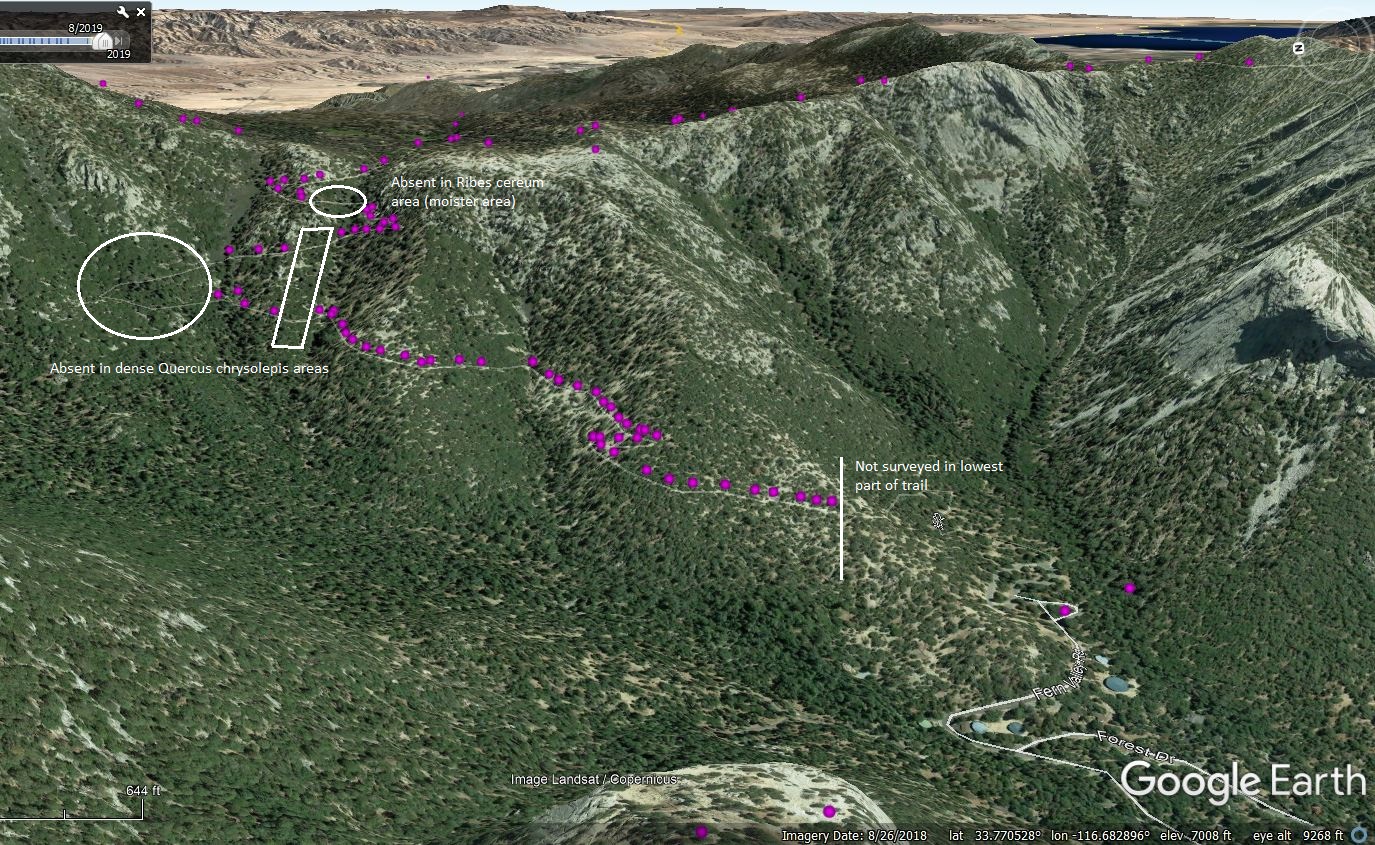
The following Google Earth views show the Trail and Tahquitz Valley, as seen from a vantage point over Idyllwild looking east, along with the distribution on the trail of the indicated species:
- Arctostaphylos Distribution on the Devils Slide Trail
- Penstemon Distribution on the Devils Slide Trail
- Pinus lambertiana, Sugar Pine, Distribution on the Devils Slide Trail
- Quercus chrysolepis, canyon live oak, Distribution on the Devils Slide Trail
See also a picture of the Devils Slide Trail area taken from the Pacific Crest Trail at about 8900 feet just west of the Marion Mountain Ridge: with labels and without labels.
Botanical Highlights of This Trail
The botanical highlights of this trail are:
- This is one of the few trails where one can see both Ponderosa Pine and Jeffrey Pine and learn the difference between them; see the notes below.
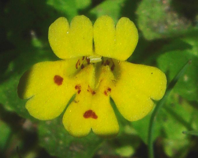
- There are NINE species of monkeyflowers on this trail! The frontal view of the flowers are shown in Fig. 2 (note that in many cases the hairiness and shape of the calyx lobes separate these species more easily than a frontal view). Fig. 2 also gives the current names for these nine species, used at iNaturalist and in the latest Jepson eFlora update. These nine species have now been placed in three different genera.
Also see Michael Charter's Monkeyflowers of the Devils Slide Trail for pictures mostly from this trail for eight of the nine species, along with a key to them for this trail (Mimulus suksdorfii is the only one not in Michael's page).
Mimulus breweri
Erythranthe breweri
Mimulus cardinalis
Erythranthe cardinalis
Mimulus floribundus
Erythranthe floribunda
Mimulus moschatus
Erythranthe moschata
Mimulus nasutus
Erythranthe nasuta
Mimulus pilosus
Mimetanthe pilosa
Mimulus primuloides
Erythranthe primuloides
Mimulus suksdorfii
Erythranthe suksdorfii
Mimulus tilingii
Erythranthe tilingii
Fig. 2. The nine species of monkeyflowers on the Devils Slide Trail. All pictures are from the Devils Slide Trail except for the thumbnail pix of M. pilosus, which is from Tahquitz Creek. However, the picture linked from that thumbnail is from the Devils Slide Trail. All pix by Tom Chester except the pix for M. cardinalis is from Michael Charters.
Click on the pictures for larger versions.
- This trail has two different spots where one can observe a species that lives only at the San Jacinto Mountains, Linanthus jaegeri, San Jacinto prickly phlox. This species has a CNPS Rare plant rank of 1B.2, a species rare in California and not found elsewhere, that is "moderately threatened". See pictures of the 13 plants of this species found in the vicinity of the Devils Slide Trail.
- The trail also contains about ten plants of Streptanthus bernardinus, Laguna Mountains jewelflower, which has a CNPS Rare plant rank of 4.3, a species of "limited distribution" that is "not very threatened".
- This trail has good specimens of California groundcone, Kopsiopsis strobilacea, a flowering plant that looks at first glance like a pine cone! See Fig. 1.
- This trail has excellent displays of western azalea, Rhododendron occidentale, a species found only in the San Jacinto Mountains, and San Diego County, in southern California. For some reason, this species skips the San Gabriel and San Bernardino Mountains. This species has large showy flowers, along with a very strong wonderful fragrance that can often be smelled before one sees the flowers.
- This trail has nice specimens of thimbleberry, Rubus parviflorus, with its large white showy flowers.


There are 137 species reliably found on this trail. One of those species has two subspecies here, making a total of 138 taxa on the trail. We have additionally found eight species that were waifs here, appearing only once or twice in our 17 years of surveying this trail.
Photographs of 83 species from this trail are at iNaturalist, 60% of the 138 taxa reliably found on the trail as of 5 July 2020. As of 15 September 2020, iNat has 436 observations from this trail by 49 different observers (note that iNat considers mosses as a plant, so their summary page reports more species than just the vascular plant species reported here).
Update: as of 6 June 2026, there are 2,946 iNat observations of 133 species from this trail! See Analysis of iNat Observations of Plants of the Devils Slide Trail, San Jacinto Mountains.
Michael Charters has a two page photo gallery from this trail from May 2009
Nick Shah has two photo galleries from this trail, of plants in order as he hiked the trail on two Lemon Lily hikes led by Dave Stith, as part of the Idyllwild Lemon Lily Festival. Both hikes continued past the top of the Devils Slide Trail, so only photographs before the "Saddle Junction" sign are part of the Devils Slide Trail. See:
See also:
- Dominant Species of Devils Slide Trail and Their Recent Death Rates for plots of the dominant species versus elevation along this trail, including their recent death rates.
- Dead Trees of the Devils Slide Trail for pictures of dead trees identified to species.
- Number Of Species In Bloom Vs. Time For Plants of the Devils Slide for a record of the number of species in bloom and finished blooming vs. time for late 2006 and early 2007.
- Plants of the Devils Slide Wet Drainages to see pictures of the seven wet drainages on this trail and a list of the prominent species at each drainage.
- Hybrids of Arctostaphylos patula and A. pringlei in the San Jacinto Mountains to see pictures and analysis of the two species on this trail and their hybrid.
Botanical Trip Reports
Tom placed botanical reports online only in the early part of his career, until he ran out of time to continue putting them online after each trip. The following reports are from 2004 to 2007, even though we continued to botanize the trail in the next thirteen years:
10 April 2004
7 July 2006
10 July 2006
14 July 2006
19 July 2006
26 July 2006
2 August 2006
11 August 2006
16 August 2006
8 July 2007
The Plant Guide
See also Plant Checklist in Family Order for this trail.
This plant trail guide was begun on 30 June 2002, and in aggregate the authors have botanized and/or hiked this trail on 100 separate days as of 1 September 2020, a span of over 20 years. In addition, we very frequently have had sharp-eyed companions botanizing the trail with us, who have been responsible for finding species we had missed; see the list at the bottom of this page.
If you are using a GPS, either a stand-alone GPS or one on your camera or phone, note that there are often problems in getting an accurate position on this trail, due to dense tree cover, the restricted sky field of view caused by the mountain, and multipath GPS signal error caused by reflections off boulders. The GPS path reported by my Garmin eTrex, even in 2020, can be very different on the way down the trail than on the way up the trail. The mileages in the guide come from the consensus track from a large number of tracks.
See Explanation of Plant Trail Guides for an explanation of the column headers. This plant trail guide is slightly different. Since there are no uncertain determinations, there is no ID? column. The #Pls in this guide includes not just the number of plants on-trail, but those in the vicinity of the trail as well. The column #all is not given here.
See Notes on the Scientific Names Used At This Site.
Version for printing, without lines and other text on this page: html (7 pages) or pdf Clickbook booklet (2 double-sided pages). (See printing instructions for an explanation of these options)
| Mile | S | # | Common Name | Scientific Name | #Pls | ||
|---|---|---|---|---|---|---|---|
| 0.00 | Beginning of trail in southeast corner of parking lot, to right of sign with introductory information; 6480 feet (1975 m) elevation. | ||||||
| 0.00 | l | 1 | mountain whitethorn | Ceanothus cordulatus | 99 / 9 | ||
| 0.00 | l | 2 | incense-cedar | Calocedrus decurrens | 30 / 7 | ||
| 0.00 | Trail turns left 90° | ||||||
| 0.01 | r | 3 | California black oak | Quercus kelloggii | 30 / 7 | ||
| 0.01 | l | 4 | canyon live oak | Quercus chrysolepis | 99 / 9 | ||
| 0.01 | b | 5 | ponderosa pine | Pinus ponderosa var. pacifica+ | 50 / 5 | ||
| 0.01 | r | 6 | white fir | Abies concolor | 99 / 9 | ||
| 0.01 | l | 7 | sugar pine | Pinus lambertiana | 99 / 9 | ||
| 0.01 | r | Sign: San Jacinto Wilderness, San Bernardino National Forest | |||||
| 0.01 | l | Sign: "Be prepared for hazardous conditions beyond this point. Permit required beyond this point. Bikes are not permitted within the San Jacinto Wilderness or on the PCT" | |||||
| 0.03 | l | 8 | fir mistletoe | Phoradendron bolleanum | 99 / 9 | ||
| 0.04 | (incense-cedar mistletoe, Phoradendron juniperinum) | ||||||
| 0.04 | b | 9 | Sierra Nevada lotus | Acmispon nevadensis var. nevadensis | 40 / 2 | ||
| 0.04 | l | 10 | former first location of chaparral lotus, last seen here in [2005?] | Acmispon grandiflorus var. grandiflorus | 20 / 2 | ||
| 0.04 | l | 11 | Indian milkweed | Asclepias eriocarpa | 20 / 2 | ||
| 0.08 | r | Huge boulder ~20 feet tall next to a huge dead white fir, showing how its trunk is made of wood spiraled around. | |||||
| 0.13 | r | 12 | Coulter pine | Pinus coulteri | 5 / 2 | ||
| 0.13 | l | (pink-bracted manzanita, Arctostaphylos pringlei ssp. drupacea) | |||||
| 0.13 | Switchback right, #1. | ||||||
| 0.15 | l | first location of chaparral lotus, Acmispon grandiflorus var. grandiflorus, in 2011 | |||||
| 0.15 | l | 13 | Davidson's buckwheat (waif) | Eriogonum davidsonii+ | 2 / 2 | ||
| 0.16 | l | 14 | snow-plant | Sarcodes sanguinea | 12 / 3 | ||
| 0.16 | l | 15 | splendid gilia | Saltugilia splendens ssp. splendens | 25 / 4 | ||
| 0.17 | b | 16 | California-aster | Corethrogyne filaginifolia+ | 50 / 4 | ||
| 0.18 | l | (narrowleaf bedstraw, Galium angustifolium ssp. angustifolium) | |||||
| 0.18 | l | (Grinnell's beardtongue, Penstemon grinnellii var. grinnellii, gone in 2020) | |||||
| 0.18 | r | 17 | leafless wintergreen (appears only infrequently) | Pyrola aphylla | 2 / 2 | ||
| 0.19 | r | (oak mistletoe, Phoradendron serotinum ssp. tomentosum) | |||||
| 0.22 | l | (forest sedge, Carex multicaulis) | |||||
| 0.23 | Switchback left, #2. Old trail continued down straight ahead. | ||||||
| 0.24 | l | 18 | white-veined wintergreen | Pyrola picta | 5 / 2 | ||
| 0.24 | l | 19 | spotted coralroot | Corallorhiza maculata | 10 / 4 | ||
| 0.25 | r | 20 | naked buckwheat | Eriogonum nudum var. pauciflorum | 30 / 3 | ||
| 0.25 | r | 21 | forest sedge | Carex multicaulis | 10 / 3 | ||
| 0.25 | r | 22 | prickly cryptantha (waif) | Cryptantha muricata+ | 4 / 2 | ||
| 0.31 | l | 23 | southern honeysuckle | Lonicera subspicata var. denudata | 5 / 5 | ||
| 0.33 | r | 24 | interior live oak (at northwest side of 10' boulder) | Quercus wislizeni var. frutescens+ | 4 / 1 | ||
| 0.36 | l | 25 | pinedrops | Pterospora andromedea | 17 / 6 | ||
| 0.37 | r | 26 | mountain grape-soda lupine | Lupinus excubitus var. austromontanus | 8 / 1 | ||
| 0.37 | r | (beautiful hulsea, Hulsea vestita ssp. callicarpha) | |||||
| 0.37 | r | 27 | San Jacinto buckwheat | Eriogonum apiculatum+ | 50 / 1 | ||
| 0.38 | r | 28 | golden yarrow | Eriophyllum confertiflorum var. confertiflorum | 10 / 1 | ||
| 0.38 | r | 29 | silky lotus (gone in 2020) | Acmispon heermannii var. heermannii | 5 / 1 | ||
| 0.38 | r | (California elegant rock-cress, Boechera californica) | |||||
| 0.39 | r | 30 | twiggy wreath plant (waifs) | Stephanomeria virgata+ | 2 / 2 | ||
| 0.40 | r | (short-flowered monardella, Monardella nana, here and at mile 0.49) | |||||
| 0.46 | r | pine died in August, 2006. | |||||
| 0.46 | r | (beaked penstemon, Penstemon rostriflorus) | |||||
| 0.46 | r | (California-fuchsia, Epilobium canum ssp. latifolium) | |||||
| 0.49 | l | 31 | pink-bracted manzanita | Arctostaphylos pringlei ssp. drupacea | 30 / 5 | ||
| 0.49 | r | 32 | *downy brome | Bromus tectorum+ | 3 / 1 | ||
| 0.54 | l | (San Bernardino rubber rabbitbrush, Ericameria nauseosa ssp. bernardina) | |||||
| 0.57 | l | 33 | Grinnell's beardtongue | Penstemon grinnellii var. grinnellii | 99 / 6 | ||
| 0.60 | l | 34 | beaked penstemon | Penstemon rostriflorus | 50 / 9 | ||
| 0.66 | b | (Laguna Mtns. jewel-flower, Streptanthus bernardinus) | |||||
| 0.68 | Switchback right, #3; elevation 6900 feet (2100 m). Old trail continued up straight ahead. | ||||||
| 0.69 | l | 35 | Laguna Mtns. jewel-flower | Streptanthus bernardinus | 10 / 2 | ||
| 0.76 | Switchback left, #4. A "mirror-image" switchback of the old trail is immediately next to this switchback. | ||||||
| 0.79 | l | 36 | bush chinquapin | Chrysolepis sempervirens | 10 / 5 | ||
| 0.81 | r | 37 | pine lousewort (in area shielded by sugar pine roots of big tree with two small trees) | Pedicularis semibarbata | 2 / 1 | ||
| 0.88 | r | 38 | Yosemite rockcress | Boechera repanda | 10 / 1 | ||
| 0.89 | l | (little prince's pine, Chimaphila menziesii, not seen here since 2005) | |||||
| 0.89 | The following three Mimulus species are only at this location in wet years (they are present in subsequent locations most years): | ||||||
| 0.89 | b | 39 | Brewer's monkeyflower | Mimulus breweri | 99 / 3 | ||
| 0.89 | b | 40 | floriferous monkeyflower | Mimulus floribundus | 99 / 3 | ||
| 0.89 | b | 41 | false monkeyflower | Mimulus pilosus | 20 / 2 | ||
| 0.89 | r | (pinegrove groundsmoke, Gayophytum oligospermum) | |||||
| 0.89 | b | 42 | mountain California-fuchsia | Epilobium canum ssp. latifolium | 30 / 4 | ||
| 0.93 | r | 43 | shy monkeyflower | Mimulus nasutus | 50 / 2 | ||
| 0.93 | l | 44 | groundsmoke | Gayophytum diffusum ssp. parviflorum | 10 / 1 | ||
| 0.94 | r | 45 | sticky cinquefoil | Drymocallis glandulosa var. viscida | 50 / 3 | ||
| 0.94 | r | 46 | Idaho bentgrass | Agrostis idahoensis | 50 / 3 | ||
| 0.94 | b | 47 | streambank lotus | Hosackia oblongifolia var. oblongifolia | 50 / 2 | ||
| 0.94 | r | 48 | fragile sheath sedge | Carex fracta | 30 / 9 | ||
| 0.94 | b | (Fendler's blue grass, Poa fendleriana ssp. longiligula) | |||||
| 0.94 | l | (deergrass, Muhlenbergia rigens, in drainage far below trail) | |||||
| 0.94 | r | 49 | bearded flatsedge | Cyperus squarrosus | 4 / 1 | ||
| 0.94 | r | 50 | Suksdorf's monkeyflower | Mimulus suksdorfii | 50 / 1 | ||
| 0.94 | r | 51 | Tiehm's rush | Juncus tiehmii | 50 / 1 | ||
| 0.94 | r | 52 | long-styled rush | Juncus longistylis | 15 / 3 | ||
| 0.95 | r | 53 | glaucus willowherb | Epilobium glaberrimum ssp. glaberrimum | 30 / 2 | ||
| 0.95 | r | 54 | pinegrove groundsmoke | Gayophytum oligospermum | 30 / 3 | ||
| 0.95 | b | 55 | western azalea | Rhododendron occidentale | 50 / 4 | ||
| 0.95 | b | 56 | Scouler's willow | Salix scouleriana+ | 20 / 5 | ||
| 0.95 | r | 57 | western marsh cudweed (waif) | Gnaphalium palustre+ | 1 / 1 | ||
| 0.95 | r | 58 | white catch-fly | Silene verecunda | 10 / 2 | ||
| 0.95 | r | 59 | mountain pink currant | Ribes nevadense | 30 / 4 | ||
| 0.95 | r | 60 | Parish's lupine | Lupinus latifolius var. parishii | 1 / 1 | ||
| 0.95 | r | 61 | willowherb | Epilobium ciliatum ssp. ciliatum | 4 / 2 | ||
| 0.95 | r | (hairy wood rush, Luzula comosa) | |||||
| 0.95 | Cross first small wet drainage (only one from Jolley Spring); elevation 7120 feet (2170 m) | ||||||
| 0.95 | r | 62 | slender hairgrass | Deschampsia elongata | 3 / 2 | ||
| 0.96 | r | 63 | broad-leaved lotus | Hosackia crassifolia var. crassifolia | 15 / 2 | ||
| 0.96 | r | 64 | California bee plant | Scrophularia californica | 10 / 2 | ||
| 0.97 | l | 65 | Parish's snowberry | Symphoricarpos rotundifolius var. parishii | 30 / 5 | ||
| 0.97 | r | (Fremont silk tassel, Garrya fremontii) | |||||
| 1.05 | r | Tree struck by lightning, which exited along its exposed root | |||||
| 1.08 | l | (green-leaf manzanita, Arctostaphylos patula, in front of pink-bracted manzanita, Arctostaphylos pringlei ssp. drupacea, on ridgeline) | |||||
| 1.10 | l | 66 | hybrid manzanita | Arctostaphylos patula X A. pringlei ssp. drupacea+ | 2 / 2 | ||
| 1.12 | l | 67 | Jeffrey pine | Pinus jeffreyi+ | 99 / 9 | ||
| 1.14 | r | (clustered broomrape, Orobanche fasciculata) | |||||
| 1.14 | r | 68 | Fendler's blue grass | Poa fendleriana ssp. longiligula | 10 / 1 | ||
| 1.19 | l | Dead tree with rocks 10 feet off ground at top. How did the rocks get there? Try to explain it, then check our answer. | |||||
| 1.19 | l | (Sierra gooseberry, Ribes roezlii var. roezlii, just below trail.) | |||||
| 1.20 | r | 69 | Parish's bedstraw | Galium parishii | 20 / 4 | ||
| 1.24 | l | (western wallflower, Erysimum capitatum var. capitatum) | |||||
| 1.24 | l | 70 | goldenrod | Solidago velutina ssp. californica | 20 / 1 | ||
| 1.24 | l | (thimbleberry, Rubus parviflorus) | |||||
| 1.24 | first location of Parish's snowberry, Symphoricarpos rotundifolius var. parishii, in 2011 | ||||||
| 1.25 | Note impressive rocks on other side of drainage. | ||||||
| 1.25 | b | 71 | scarlet monkeyflower | Mimulus cardinalis | 30 / 2 | ||
| 1.25 | r | 72 | Cleveland's horkelia | Horkelia clevelandii var. clevelandii+ | 20 / 3 | ||
| 1.25 | r | (arroyo willow, Salix lasiolepis) | |||||
| 1.25 | Cross small moist drainage #2 (first of four crossings of Powderbox Spring drainage); elevation 7320 feet (2230 m) | ||||||
| 1.25 | b | 73 | western columbine | Aquilegia formosa | 50 / 3 | ||
| 1.25 | l | 74 | giant red paintbrush (died here in 2007) | Castilleja miniata ssp. miniata | 10 / 3 | ||
| 1.25 | r | 75 | Fremont's goosefoot | Chenopodium fremontii | 20 / 2 | ||
| 1.25 | best location for broad-leaved lotus, Hosackia crassifolia var. crassifolia | ||||||
| 1.25 | r | 76 | granite prickly phlox | Linanthus pungens | 38 / 4 | ||
| 1.25 | r | 77 | San Bernardino rubber rabbitbrush | Ericameria nauseosa var. bernardina+ | 10 / 7 | ||
| 1.25 | r | 78 | Fremont silk tassel | Garrya fremontii | 30 / 4 | ||
| 1.25 | l | 79 | narrowleaf bedstraw | Galium angustifolium ssp. angustifolium | 5 / 3 | ||
| 1.26 | r | 80 | Martin's paintbrush | Castilleja applegatei ssp. martinii | 6 / 3 | ||
| 1.26 | l | 81 | California coffeeberry | Frangula californica+ | 30 / 5 | ||
| 1.31 | l | 82 | *prickly lettuce (waif) | Lactuca serriola+ | 1 / 1 | ||
| 1.32 | r | (bracken, Pteridium aquilinum var. pubescens) | |||||
| 1.35 | b | 83 | forest goosefoot | Chenopodium atrovirens | 20 / 5 | ||
| 1.36 | l | 84 | branching phacelia | Phacelia ramosissima | 10 / 3 | ||
| 1.37 | r | (blue elderberry, Sambucus nigra ssp. caerulea) | |||||
| 1.37 | l | (only seen in 2012: tinker's penny, Hypericum anagalloides; baby clover, Trifolium sp.; June grass, Koeleria macrantha) | |||||
| 1.37 | Cross small wet drainage #3 (first of two of drainage containing Middle Spring; second is above Middle Spring); elevation 7380 feet (2250 m) | ||||||
| 1.37 | r | 85 | baby brittle bladder fern (not seen since 2007) | Cystopteris fragilis | 4 / 3 | ||
| 1.37 | r | 86 | green miner's lettuce | Claytonia parviflora ssp. viridis | 12 / 1 | ||
| 1.37 | r | Very small Mimulus nasutus and M. floribundus, just 2-4 cm (1-2 inch) tall | |||||
| 1.38 | r | 87 | Sierra gooseberry | Ribes roezlii var. roezlii | 15 / 4 | ||
| 1.41 | l | 88 | little prince's pine | Chimaphila menziesii | 6 / 4 | ||
| 1.42 | Seep in wet years | ||||||
| 1.42 | r | 89 | thimbleberry (small plant never seen to bloom at this location) | Rubus parviflorus | 30 / 3 | ||
| 1.42 | l | 90 | bracken | Pteridium aquilinum var. pubescens | 20 / 3 | ||
| 1.46 | l | Second location of hybrid manzanita, Arctostaphylos patula X A. pringlei ssp. drupacea | |||||
| 1.46 | Trail turns 90 degrees right. | ||||||
| 1.48 | Cross bouldery drainage | ||||||
| 1.50 | Switchback right, #5; elevation 7500 feet (2290 m). | ||||||
| 1.54 | Cross same bouldery drainage again at higher elevation. | ||||||
| 1.57 | r | (white fir, Abies concolor, tree that fell over when it had a good-sized trunk, grew a new erect trunk which was lost, and now has two side branches competing to be the new main trunk) | |||||
| 1.59 | r | View of Tahquitz Peak Lookout | |||||
| 1.60 | r | View of Lily Rock, Palomar Mountain Range, San Diego County coastline, Santa Margarita Mountains and closer ranges. | |||||
| 1.66 | r | (California chicory, Rafinesquia californica, seen only in 2010) | |||||
| 1.69 | Cross wet drainage #4, a large one ~80 feet above Middle Spring, second of the two crossings of this drainage; elevation 7600 feet (2315 m) | ||||||
| 1.69 | r | 91 | blue elderberry | Sambucus nigra ssp. caerulea | 20 / 4 | ||
| 1.70 | Cross separate branch of same drainage | ||||||
| 1.70 | l | 92 | red-stemmed spring beauty | Claytonia rubra | 20 / 2 | ||
| 1.70 | l | first mature brittle bladder fern, Cystopteris fragilis | |||||
| 1.76 | Trail turns left 50 degrees; tall rock walls on right. | ||||||
| 1.80 | l | (California cliff-brake, Pellaea mucronata var. californica) | |||||
| 1.80 | l | 93 | green-leaf manzanita | Arctostaphylos patula | 50 / 9 | ||
| 1.81 | l | 94 | coyote tobacco (waif) | Nicotiana attenuata+ | 3 / 1 | ||
| 1.85 | Enter Powderbox Spring drainage with lots of western azalea, the best display of it on the trail. | ||||||
| 1.85 | first live giant red paintbrush, Castilleja miniata ssp. miniata, in 2011 | ||||||
| 1.85 | l | 95 | Nevada cinquefoil | Drymocallis lactea var. lactea | 30 / 2 | ||
| 1.85 | b | 96 | western wallflower | Erysimum capitatum var. capitatum | 30 / 2 | ||
| 1.85 | Cross wet drainage #5, second of the four crossings of Powderbox Spring drainage; elevation 7680 feet (2340 m) | ||||||
| 1.85 | First good stand of thimbleberry, Rubus parviflorus | ||||||
| 1.85 | r | (San Jacinto Mts. Keckiella, Keckiella rothrockii var. jacintensis) | |||||
| 1.86 | b | 97 | wax currant | Ribes cereum var. cereum | 50 / 4 | ||
| 1.91 | Switchback left, #6. (A blocked-off old trail continues down straight ahead.) | ||||||
| 1.99 | Switchback right, #7, near drainage from Powderbox Spring again. | ||||||
| 2.02 | Switchback left, #8, with a massive rock fortress above the switchback. | ||||||
| 2.02 | r | (Just off-trail beyond the switchback, in the boulders at head level and above, is San Jacinto prickly phlox, Linanthus jaegeri; and western polypody, Polypodium hesperium. ~25 feet farther to south is little-leaf mock orange, Philadelphus microphyllus, at trail level.) | |||||
| 2.02 | l | 98 | *bull thistle (waif) | Cirsium vulgare+ | 1 / 1 | ||
| 2.02 | r | 99 | Parish's campion | Silene parishii | 10 / 2 | ||
| 2.04 | l | Sign: "Soil in the area is fragile. Please stay on the trail." | |||||
| 2.07 | r | 100 | musk monkeyflower | Mimulus moschatus | 99 / 2 | ||
| 2.07 | r | 101 | San Jacinto Mts. keckiella | Keckiella rothrockii var. jacintensis | 10 / 3 | ||
| 2.07 | r | 102 | hairy wood rush | Luzula comosa | 99 / 2 | ||
| 2.07 | Cross wet drainage #6, a small one immediately above Powderbox Spring; third of the four crossings of this drainage; elevation 7840 feet (2390 m); curve left | ||||||
| 2.07 | r | 103 | vari-nerved sedge | Carex heteroneura | 5 / 1 | ||
| 2.07 | r | (California geranium, Geranium californicum) | |||||
| 2.07 | r | 104 | changeable phacelia | Phacelia mutabilis+ | 10 / 2 | ||
| 2.07 | r | 105 | mountain rock-cress | Boechera retrofracta X+ | 10 / 2 | ||
| 2.07 | b | Best spot for Cleveland's horkelia, Horkelia clevelandii var. clevelandii | |||||
| 2.07 | r | 106 | blue-eyed grass | Sisyrinchium bellum+ | 1 / 1 | ||
| 2.07 | r | 107 | larger mountain monkeyflower | Mimulus tilingii | 30 / 1 | ||
| 2.07 | b | 108 | rigid hedge-nettle | Stachys rigida | 8 / 1 | ||
| 2.08 | r | 109 | Jepson's blue wildrye | Elymus glaucus ssp. glaucus | 5 / 2 | ||
| 2.08 | l | View of Diamond Valley Reservoir, shaped like an hourglass. | |||||
| 2.08 | r | 110 | California groundcone | Kopsiopsis strobilacea | 30 / 2 | ||
| 2.13 | Trails turns 90 degrees right at ridge | ||||||
| 2.14 | r | (Many California groundcone, Kopsiopsis strobilacea) | |||||
| 2.20 | Switchback right, #9. | ||||||
| 2.25 | l | 111 | southern mountain-monardella | Monardella australis ssp. australis | 5 / 2 | ||
| 2.25 | r | Trail gradually bends left. Note the window formed by the boulders on right | |||||
| 2.27 | l | 112 | prickly hawkweed | Hieracium horridum | 10 / 1 | ||
| 2.27 | l | Best location for mountain rock-cress, Boechera retrofracta X | |||||
| 2.27 | l | (western polypody, Polypodium hesperium, just above head level hidden behind boulder between white fir and canyon live oak) | |||||
| 2.27 | l | 113 | Watson's spike-moss | Selaginella watsonii | 5 / 1 | ||
| 2.27 | l | 114 | southern Sierra phacelia | Phacelia austromontana | 40 / 1 | ||
| 2.27 | l | 115 | small fescue (waif) | Festuca microstachys | 1 / 1 | ||
| 2.27 | l | 116 | squirreltail | Elymus elymoides | 2 / 1 | ||
| 2.28 | l | 117 | rock buckwheat | Eriogonum saxatile | 5 / 1 | ||
| 2.35 | r | (field of swamp sedge, Carex senta. Parish's yampah, Perideridia parishii, 30 feet below trail) | |||||
| 2.35 | Enter seep area | ||||||
| 2.35 | l | 118 | long-anthered rush | Juncus macrandrus | 80 / 1 | ||
| 2.35 | l | 119 | pearlwort | Sagina saginoides | 20 / 1 | ||
| 2.35 | l | 120 | Kentucky blue grass | Poa pratensis ssp. agassizensis | 10 / 1 | ||
| 2.35 | b | 121 | California geranium | Geranium californicum | 5 / 1 | ||
| 2.35 | l | 122 | plain mariposa lily | Calochortus invenustus | 1 / 1 | ||
| 2.35 | l | 123 | lemon lily | Lilium parryi+ | 1 / 1 | ||
| 2.35 | l | 124 | glandular willowherb | Epilobium ciliatum ssp. glandulosum | 2 / 1 | ||
| 2.35 | l | 125 | primrose monkeyflower | Mimulus primuloides var. primuloides | 10 / 1 | ||
| 2.35 | l | Best location for streambank lotus, Hosackia oblongifolia var. oblongifolia, in normal years | |||||
| 2.35 | l | 126 | abrupt-beak sedge | Carex abrupta | 10 / 1 | ||
| 2.35 | l | 127 | tinker's penny | Hypericum anagalloides | 50 / 1 | ||
| 2.35 | Cross shallow drainage at head of Powderbox Spring drainage; last of the four crossings of this drainage; elevation 8010 feet (2440 m) | ||||||
| 2.37 | Switchback left, #10. (on right: jct. with a blocked-off old trail; a path straight ahead leads to the hanging "picture window" rock seen from here; and six plants of San Jacinto prickly phlox, Leptodactylon jaegeri). | ||||||
| 2.44 | r | 128 | San Gabriel beardtongue | Penstemon labrosus | 10 / 1 | ||
| 2.44 | r | (Elmer's needlegrass, Stipa occidentalis var. pubescens) | |||||
| 2.45 | r | 129 | pussy paws | Calyptridium monospermum | 20 / 1 | ||
| 2.52 | End Devils Slide Trail at Saddle Junction, 8075 feet (2460 m) elevation, a jct. with 4 other trails. | ||||||
| SPECIES ONLY FOUND OFF-TRAIL, which consequently were not numbered in the guide above, in order of appearance. | |||||||
| 0.04 | 130 | incense-cedar mistletoe | Phoradendron juniperinum | 1 / 1 | |||
| 0.19 | 131 | oak mistletoe | Phoradendron serotinum ssp. tomentosum | 1 / 1 | |||
| 0.37 | 132 | beautiful hulsea | Hulsea vestita ssp. callicarpha | 10 / 1 | |||
| 0.38 | 133 | California elegant rock-cress | Boechera californica | 1 / 1 | |||
| 0.40 | 134 | short-flowered monardella | Monardella nana | 2 / 2 | |||
| 0.94 | 135 | deergrass | Muhlenbergia rigens | 5 / 1 | |||
| 1.14 | 136 | clustered broomrape | Orobanche fasciculata | 6 / 1 | |||
| 1.25 | 137 | arroyo willow | Salix lasiolepis | 1 / 1 | |||
| 1.37 | 138 | June grass | Koeleria macrantha | 2 / 1 | |||
| 1.66 | 139 | California chicory (waif) | Rafinesquia californica | 1 / 1 | |||
| 1.80 | 140 | California cliff-brake | Pellaea mucronata var. californica | 2 / 1 | |||
| 2.02 | 141 | San Jacinto prickly phlox | Linanthus jaegeri | 8 / 2 | |||
| 2.02 | 142 | little-leaf mock orange | Philadelphus microphyllus | 1 / 1 | |||
| 2.02 | 143 | western polypody | Polypodium hesperium | 2 / 1 | |||
| 2.35 | 144 | swamp sedge | Carex senta | 50 / 1 | |||
| 2.35 | 145 | Parish's yampah | Perideridia parishii | 10 / 1 | |||
| 2.44 | 146 | Elmer's needlegrass | Stipa occidentalis var. pubescens | 1 / 1 | |||
Comments On Specific Species
Pinus ponderosa, P. jeffreyi. These two similar yellow pines are easily discriminated on this trail by the length of the cones and elevation. P. ponderosa has small cones 6.5 to 9.5 cm (2.5 to 3.7 inches) long; P. jeffreyi cones are nearly twice as long, 12.0 to 17.2 cm (4.7 to 6.8 inches).
P. ponderosa is found at the trailhead up to mile 0.25 below an elevation of 6660 feet; most of the specimens in this area are at elevations below this trail. P. jeffreyi is found only on the upper part of the trail, beginning at mile 1.10 at an elevation of 7200 feet; most of the specimens in this area are in Tahquitz Valley above this trail.
See Pinus jeffreyi and P. ponderosa for a map of the distribution of these species on this trail, discussions of the unreliable commonly-used discriminants of these species, and pictures of the cones.
Corethrogyne filaginifolia. These plants key out to Corethrogyne filaginifolia var. glomerata in Munz. Also, some of these plants are unusual in having two-lipped corollas. The usual ligule is spreading, but the other ligule is erect, forming a cylinder around the disk flowers!
Quercus wislizeni var. frutescens. As far as we know, this is the highest elevation specimen of this species, at ~6500 feet. Munz gives an upper elevation of 5000 feet, and the Jepson Manual gives 2000 m = 6500 feet.
Ericameria nauseosa ssp. bernardina. The first occurrence of this species on trail in 2002 was no longer present in 2003, and has been removed from the guide. It was approximately at the location of the first off-trail specimen at mile 0.53.
Frangula californica. If one takes the taxa in the Jepson Manual seriously, there would be three on this trail:
- Frangula californica ssp. californica, with nearly glabrous leaves;
- Frangula tomentella ssp. cuspidata, with leaves silvery below with dense stellate hairs between the veins, "dentate to dentate-serrate", with a tip "abruptly narrowed to a point"; and
- Frangula tomentella ssp. tomentella, with leaves silvery below with dense stellate hairs between the veins, entire, oblong, with a nearly rounded tip
Clearly, it is unreasonable to declare that there are three taxa on this trail, and we treat these all as F. californica, without subspecies.
Salix scouleriana. These were keyed out using blooms in April 2004, four plants from the drainage at mile 0.95 and one plant from the drainage at mile 1.23. All plants were males, and are only consistent with a S. scouleriana id from the JM staminate key.
The plants at mile 0.95 show a lot of similarity to Salix lasiolepis. The leaf margins are not uniformly turned down, which is more akin to S. lasiolepis than to the other S. scouleriana on the trail at higher elevation. Many of the leaves, especially on the young whips at the base of the taller trunks, are dead ringers for S. lasiolepis leaves, being elliptic/symmetric and thus very un-Scouler-like.
The plants at higher elevation all have leaves with uniformly-turned down margins, and are clearly all S. scouleriana, with the exception of the single off-trail location of S. lasiolepis at mile 1.28.
Arctostaphylos patula X A. pringlei ssp. drupacea. These specimens caused me great grief for their determination until I finally figured out and proved that these were hybrids of these two species. See Hybrids of Arctostaphylos patula and A. pringlei in the San Jacinto Mountains.
Dead tree with rocks 10 feet off ground near top of tree. Presumably, the ground level has not changed since the tree was alive, since the trunk/root junction is still at ground level. The area has the usual steep slope, so it is highly likely that the slope is the same as it always was, except for the trail construction.
Possible explanations:
- Trail workers threw the rocks there while constructing or maintaining the trail.
- In small rockslides, some rocks hit the trail, which is 3 feet above the base of this tree, and manage to bounce 7 feet into the air to land in the tree stump.
- The rocks fell when there was ~ten feet of snow, making that height the "ground" level during the rock fall. The only slight problem with this hypothesis is that nearly all the rocks in the area are also covered with ~ten feet of snow.
Nick Nixon informs us that this tree is known as the Wishing Tree, and that he knows hikers that make a point of bringing a rock or two to throw at the tree. If the rock catches in the tree, those hikers believe their wish will be granted.
Tom picked up a rock, and lodged it in the tree with his first toss. (;-)
Horkelia clevelandii. The first occurrence on the trail is a single specimen that usually hides under a rock or another plant. The second occurrence at mile 2.04 has bunches of the plants.
Eriogonum apiculatum. Only in some years are plants of this species seen close to the trail, but a large population exists above the trail.
Phacelia mutabilis. There were a number of plants at mile 2.07 prior to 2007, when a gopher took out every single plant. Beginning about ten years later, a few plants have re-appeared in this first spot.
Sisyrinchium bellum. This plant is utterly invisible except for the few days when it has blooms in a given year. We're also not sure that it blooms every year.
Lilium parryi. This is the famous Munchkin Lemon Lily.
Bromus tectorum, Lactuca serriola, Cirsium vulgare. These non-native plants are probably waifs brought in by hikers or horses, and are weeded out when seen.
Cryptantha muricata, Eriogonum davidsonii, Gnaphalium palustre, Nicotiana attenuata, Stephanomeria virgata. These plants were only seen in a single one year, 2003, most with only a single specimen of each, and are probably waifs brought in by hikers or horses.
Boechera retrofracta X. There is no binomial name available for our plants that were formerly erroneously called Arabis holboellii. See Arabis = Boechera species with non-erect fruit.
Species that did not bloom in 2003:
| Common Name | Latin Name |
|---|---|
| Perennial species that were old enough to bloom, but did not bloom | |
| Indian milkweed | Asclepias eriocarpa |
| golden yarrow | Eriophyllum confertiflorum var. confertiflorum |
| Species with all plants too young to bloom in 2003, probably due to the 2001-2002 drought | |
| California geranium | Geranium californicum |
| lemon lily | Lilium parryi |
| larger mountain monkeyflower | Mimulus tilingii |
| California beeplant | Scrophularia californica |
| hedge-nettle | Stachys rigida var. ajugoides |
1 The Devils Slide Trailhead is the third highest trailhead in the Idyllwild Area. The higher two are:
- The South Ridge Trailhead is just 70 feet higher than the Devils Slide Trailhead. That Trailhead is reached by a steep dirt road that is sometimes not passable even by AWD cars. The South Ridge Trail is also hotter in the summer due to its south-facing slopes.
- The Fuller Ridge Trailhead is at 7700 feet, but its access is via a 45 minute drive on a dirt road.
We thank:
- Nancy Accola for spotting the Boechera californica;
- Jim Adams for sighting the Muhlenbergia rigens off-trail while he was running the trail;
- Adrienne Ballwey for spotting the Orobanche fasciculatus;
- Michael Charters for finding the Corallorhiza maculata, taking the picture to help identify the Streptanthus bernardinus, and determining that the Sagina was a perennial, not an annual;
- RT Hawke for spotting the Mimulus suksdorfii;
- Keir Morse for spotting the Cyperus squarrosus;
- Nick Nixon for finding the Pinus coulteri on the trail;
- Don Rideout for helping with the GPS surveys devoted to single species; and
- an anonymous reader for finding the Cystopteris fragilis.